Tag:historic=pound
 |
| Description |
|---|
| A former amenity to hold stray or seized animals, often walled. |
| Group: historic |
| Used on these elements |
| Useful combination |
| See also |
| Status: in use |
| Tools for this tag |
A pound (also pinfold, penfold, village pound, town pound, animal pound or poundfield) is an often walled, rarely roofed area in a village, market town or fair area (could be just a cross roads) in which stray or seized animals were kept, until they were released to their owners for a fee. They come in all shapes: square, rectangular, circular and oval. Some of them go back to the Middle Ages (historic:civilization=medieval), whereas others were built in the 19th century. They were a safety measure and a source of income for the community. They are quite common in rural England (as well as in New England and other areas where the British colonized) where they have often been restored and sometimes made part of a heritage trail including a plaque or other type of information.
How to map
Set a node or draw the area and add historic=pound. You may add the wall as barrier=wall with its material=*.
If it is known that the pound was only for a certain type of animal (i.e. cattle pound), you may use animal=*.
If the pound is a listed structure on a heritage database, use the appropriate heritage=* and reference (ref:IE:smr=*, ref:cadw=*, HE_ref=*, ref:nrhp=* etc...).
If the building date is known (sometimes recorded on the plaque/ information panel), use start_date=*. If a restoration date is given, you may use restoration_date=* (more commonly in use than restored_date=*).
If there is a plaque explaining the site, add that as well using the tags described under memorial=plaque.
Many pounds are recorded on Wikimedia Commons, categorized by location under ![]() Historic animal pounds. If an image is available, you can also add
Historic animal pounds. If an image is available, you can also add wikimedia_commons=*. If it is not recorded on Wikimedia Commons yet, why not take a picture and upload it?
Pound vs. pinfold
Several of these sites are mapped as historic=pinfold in England instead. See page discussion for further detail.
"pound" in the Republic of Ireland
In the Republic of Ireland[1], the term "pound" was also used until the early 20th century[2] in its oldest meaning as an animal enclosure with no legal circumstances or fee paying attached, but the location of those is for the most part forgotten and untraceable, so it will be almost impossible to map them. They can be covered by tagging the name=* with the value Pound Field, The Pound Field, Páirc na Phúnta or whatever else is the field name in combination with a landuse=* (farmland, meadow) etc. An exception are those, where an actual pound can be traced on old maps in one of those fields, then historic=pound can be applied.
name:etymology
There are sometimes street names referring to the pound to be found:
- Pound Lane, Borris, Co. Carlow, Ireland
- Pound Close, Berkswell, England
In those cases, you can add that the pound lent its name to the street using name:etymology=*.
In the Republic of Ireland, field names and public spaces can sometimes still bear witness for a pound having been in the field or in that area:
- The Pound Field, Co. Cork, recorded on Openstreetmap
- The Pound Field, Co. Meath, recorded on OSM
- The Pound, Co. Kildare, recorded on OSM
- The Pound, Maynooth, Co. Kildare, recorded on OSM
- The Pound (park), Co. Donegal, recorded on OSM
- Páirc an Púnta, Co. Mayo, recorded in the Schools' Collection
- The Pound, Co. Mayo recorded in the Schools' Collection
- The Pound field, Co. Leitrim, recorded in the Schools' Collection
- overpass-turbo query looking for
name:etymology=*values containing "animal pound"
Gallery
-
 Pound in Tormarton, Village Pound by Rick Crowley, CC BY-SA 2.0, via Wikimedia Commons
 -
 Circular village pound in Syerston, The village pound by Jonathan Thacker, CC BY-SA 2.0, via Wikimedia Commons
 -
 Plaque on the pound in Clymping, Clymping Village Pound by N Chadwick, CC BY-SA 2.0, via Wikimedia Commons
 -
 Clymping village pound, Clymping Village Pound by N Chadwick, CC BY-SA 2.0, via Wikimedia Commons
 -
 Pinfold in Raskelf
 -
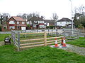
 Cattle Pound near Newport, by Gareth James, CC BY-SA 2.0, via Wikimedia Commons
 -
 Fox Lane cattle pound, Southgate, London, by Philafrenzy, CC BY-SA 4.0, via Wikimedia Commons
 -
 Becket Town Pound, Massachusetts, by John Phelan, CC BY 4.0, via Wikimedia Commons
 -
 Town Pound, Porter, Maine, by Magicpiano, CC BY-SA 4.0, via Wikimedia Commons


See also
- Mapping of New England's Historic Town Pounds (& Slides), a lightning talk given at State of the Map U.S. 2025.
Footnotes
- ↑ Likely the whole of the island, but no sources for Northern Ireland were consulted, so I'm being cautious about using "Ireland".
- ↑ For example https://duchas.ie/en/cbes/4666607/4666253/4667967, accessed 2024-01-14.