Tag:irrigation=pivot
Jump to navigation
Jump to search
 |
| Description |
|---|
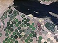
| Farmland with center-pivot irrigation system |
| Group: waterways |
| Used on these elements |
| Requires |
| See also |
| Status: de facto |
| Tools for this tag |

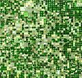
This tag is meant for center-pivot irrigation fields. It is added to an area which is tagged landuse=farmland or sometimes landuse=orchard.
Also see irrigated=yes for other types of irrigation.
History
The story is told here (Wired 2008). The first patent was applied for in 1949.
Examples
-
 Kansas, USA
 -
 Washington, USA
 -
 Saudi Arabia


