Tag:man_made=ferry_cable
Jump to navigation
Jump to search
 |
| Description |
|---|
| A wire spun across a river in order to guide a ferry |
| Group: man made |
| Used on these elements |
| Status: in use |
| Tools for this tag |
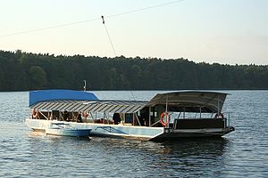
A ferry cable is a wire spun across a river in order to guide a ferry. Such a wire is not used for electric power supply of a ferry and it is grounded. However there exist a few ferries, which got their power from an overhead line. These lines are to be classified as minor_powerlines and the attributes for voltage, frequency and cable count should be set as for normal powerlines.

Draw a line ![]() representing the ferry cables, using the towers carrying the cable as nodes. Do not connect the ferry cable with the river it crosses and add an appropriate
representing the ferry cables, using the towers carrying the cable as nodes. Do not connect the ferry cable with the river it crosses and add an appropriate layer=* tag. Do not forget to mark the support structures as man_made=mast or man_made=tower.
Tags to use in combination
operator=*- Operator of the ferrydescription=*- To provide additional information about the related element to the end map user.name=*- The primary name: in general, the most prominent signposted name or the most common name in the local language(s).
See also
seamark:type=cable_overhead- Wires, fibres, wire rope or chains, passing over or nearby navigable waters.ferry:cable=*- A cable ferry, chain ferry, or reaction ferry is a ferry that is guided or propelled by cables connected to both shores.