Tag:man_made=ski_jump
Jump to navigation
Jump to search
 |
| Description |
|---|
| The outline of the man-made, above-ground structure of a ski jumping hill, usually an in-run tower. |
| Group: man made |
| Used on these elements |
| Useful combination |
|
| See also |
| Status: in use |
| Tools for this tag |
The man made structure (usually in-run tower) of a ![]() Ski jumping hill. Use this tag to map the physical structure itself, i.e. the man made part where the in-run is located, not the ground-level part i.e. the landing slope. If the structure deserves it, also use
Ski jumping hill. Use this tag to map the physical structure itself, i.e. the man made part where the in-run is located, not the ground-level part i.e. the landing slope. If the structure deserves it, also use building=yes.
See piste:type=ski_jump for how to map the rest of the ski jumping facility.
Examples
-
 Typical man-made ski jumping structures (in-run towers)
 -
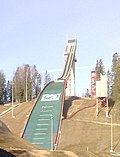 The man-made structure extends further down to the halfway of the landing area
 -
 The man-made structure extends only partially down the in-run
 -
 No elevated man-made structure whatsoever


.jpg)