Tag:natural=fumarole
Jump to navigation
Jump to search
.jpg) |
| Description |
|---|
| A fumarole is an opening in a planet's crust, which emits steam and gases |
| Group: natural |
| Used on these elements |
| See also |
| Status: approved |
| Tools for this tag |
A Fumarole is an opening in a planet's crust, which emits steam and gases. They are found in volcanic areas and geothermal fields.
- See also Fumarole on Wikipedia
How to map
Set a node ![]() and add
and add natural=fumarole.
Similar tags
Fumaroles are similar to geysers and hot_springs. There are a few key differences:
- Hot Springs produce hot water.
- Fumaroles emit small quantities of steam/gas (no liquid water, but they may cause nearby water to boil).
- Geysers dramatically eject a large volume of water and steam in a burst upwards.
Examples of fumaroles
-
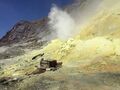 A fumarole on Whakaari / White Island, New Zealand
 -
 A fumarole at Námafjall, Iceland
 -
 Less dramatic fumaroles at Karapiti / Craters of the Moon, New Zealand


Examples of ambiguous situations
-
 A fumarole beneath a
 mud pool, which causes the mud to boil and bubble. If it is producing water, use
 hot_spring. If it is only producing steam/gas, usefumarole. -
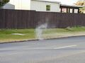 Geothermal steam rising out of a storm drain.


Examples of other geothermal features


Extinct fumaroles

Fumaroles may become extinct, either as a natural process or if geothermal bores or power plants are constructed nearby.
Extinct fumaroles should normally be deleted from OSM. In rare cases, if they are very significant they could be mapped as was:natural=fumarole.