Tag:natural=arch
 |
| Description |
|---|
| A rock arch naturally formed by erosion, with an opening underneath. |
| Group: natural |
| Used on these elements |
| Useful combination |
|
| Status: in use |
| Tools for this tag |
|
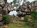
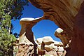
The tag natural=arch is used to map a natural arch or bridge: a landform where a rock arch has formed by erosion, with an opening underneath.
Unlike with a cave or other features, one can look through an arch from one side and see a substantial amount of ground or sky on the other. Natural arches are often landmarks, and may be sought out by tourists and photographers. Geologists may study natural arches to understand the erosion processes that formed them.
Like manmade bridges, natural arches can have a highway on top; the difference is that the actual hole is formed by erosion.
Examples include those listed here on Wikipedia: Notable natural arches.
How to map
Place a node at the center of the arch and add the tag natural=arch. Alternatively, a large arch can be mapped as an area.
Generic tags such as name=* and wikipedia=* apply.
Gallery

Tadrart Rouge range, Algeria
Tirumala, India

The Azure Window, Malta
Metate Arch, Utah

Natural Bridge, Virginia

Durdle Door, Dorset, UK


.jpg)

.jpg)
