Tag:navigationaid=vasi
Jump to navigation
Jump to search
 |
| Description |
|---|
| Visual Approach Slope Indicator. |
| Group: aeroways |
| Used on these elements |
| Requires |
| Status: in use |
| Tools for this tag |
The Visual Approach Slope Indicator (VASI) is a system of lights on the side of an airport runway threshold that provides visual descent guidance information during approach. These lights may be visible from up to 8 kilometers (5.0 mi) during the day and up to 32 kilometers (20 mi) or more at night.
How to map
Set a node ![]() where the light is and add
where the light is and add aeroway=navigationaid + navigationaid=vasi
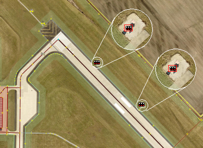
You will find the VASI a few 100 m behind the beginning of the runway, mostly on the left side. On good satellite images, you can see two times 2 floodlights. Add 2 nodes each in the middle of the system.
See also
- Visual approach slope indicator on Wikipedia
