Tag:railway=hirail_access
 |
| Description |
|---|
| An point along a railway where hirail vehicles can join the railway |
| Group: railways |
| Used on these elements |
| Status: in use |
| Tools for this tag |
|
railway=hirail_access can be used to map a point designed for ![]() Hi-Rail vehicles (also called
Hi-Rail vehicles (also called ![]() DMVs) to enter and exit the railway line.
DMVs) to enter and exit the railway line.
Hi-rail vehicles need a paved area to access the railway line, so they usually use level_crossings. However, some railway networks have very few level crossings, or it is not acceptable to use the level crossing for hirail vehicles to board the railway. In these situations, designated hirail access points are built.
Hi-rail vehicles are usually used for maintenance only. In rare situations, passenger railways may use hi-rail vehicles. Example
How to map
Add a ![]() node on the railway track. Use railway=hirail_access for hirail access points that do not qualify as railway=level_crossing.
node on the railway track. Use railway=hirail_access for hirail access points that do not qualify as railway=level_crossing.
railway=level_crossing + surface=paved implies railway=hirail_access.
Photos

A dedicated access point for Hi-Rail Vehicles. It looks like a level crossing that leads nowhere.
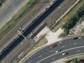
Aerial view of a hirail_access point for maintenance vehicles

A hirail_access point for passenger vehicles. View Video

A hi-rail vehicle driving along a railway line.


