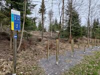
Tag:route=fitness_trail
Jump to navigation
Jump to search
| Description |
|---|
| route relation for a fitness trail |
| Group: routes |
| Used on these elements |
| Useful combination |
| Status: in use |
| Tools for this tag |
|
A ![]() fitness trail consists of a path or course equipped with obstacles or stations distributed along its length for exercising the human body to promote good health.
fitness trail consists of a path or course equipped with obstacles or stations distributed along its length for exercising the human body to promote good health.
How to map
Create Relation:route with tags following these scheme:
- type=route
- route=fitness_trail
- name=* the path is known by its name (e.g. Aigle for the path in Aigle)
- distance=* the length of the trail in km, e.g. 5.8. If the distance is given in miles, is has to be stated explicitly, e.g. 10.5 mi.
- operator=* the route is operated by this authority, e.g. Fondation Parcours Vita
Members for the route relation
| Object type | Role | Recurrence | Description |
|---|---|---|---|
| None, forward, backward | One or more | Any kind of ways along the fitness trail route. Can be tagged with forward/backward to indicate the direction of the route (respective to the direction of the tagged way) | |
| station | One or more | exercise stations, see leisure=fitness_station | |
| start, stop, start_stop | Optional | Markings for the start and endpoint of the fitness trail. If start and stop is the same use role start_stop or add the node twice with each of the roles. |
