Tag:tower:type=watchtower
Jump to navigation
Jump to search
 |
| Description |
|---|
| Watch Tower from which a sentinel or guard may observe the surrounding area. |
| Rendering in OSM Carto |
| Group: man made |
| Used on these elements |
| Requires |
| Useful combination |
| See also |
| Status: de facto |
| Tools for this tag |
A ![]() watchtower, or watch tower, is a type of fortification used in many parts of the world. It differs from a regular tower in that its primary use is military, and from a turret in that it is usually a freestanding structure. Its main purpose is to provide a high, safe place from which a sentinel or guard may observe the surrounding area.
watchtower, or watch tower, is a type of fortification used in many parts of the world. It differs from a regular tower in that its primary use is military, and from a turret in that it is usually a freestanding structure. Its main purpose is to provide a high, safe place from which a sentinel or guard may observe the surrounding area.
How to map
Set a node ![]() or draw as an area
or draw as an area ![]() along the outline and tag it with
along the outline and tag it with
Tags which can be used in combination
name=*- Name of the towerhistoric=yes- If the watchtower is historicalaccess=yes- Public access possibleheight=*- Height in metersstart_date=*- Date when feature opened or the construction of the feature finishedheritage=*- Site/building/object registered by an official heritage organisationele=*- Elevation at the foot of the tower above sea level, in metresdisused=yes- when it is no longer used or is blockedstep_count=*- can be added to indicate the number of steps, useful especially for cases where number of steps is low and sparse. It indicates in such cases that steps are less significant obstacle than indicated just by their length.
Example
-
 Panglao watchtower in Bohol, Philippines
 -
 Roman Watchtower in Germany
 -
 Concentration camp Auschwitz, Poland
 -
 Former ammunition warehouse with watchtower in Bossow, Germany
 -
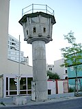 Watchtower on Berlin Wall
 -
 Modern watchtower used at Sing Sing Prison, New York, USA


