Tag:wetland=wet_meadow
Jump to navigation
Jump to search
| Description |
|---|
| Semi-wetland meadow |
| Rendering in OSM Carto |

|
| Group: natural |
| Used on these elements |
| Requires |
| Useful combination |
| Status: de facto |
| Tools for this tag |
|
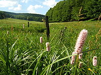
A semi-wetland meadow which is saturated with water throughout much of the year. Can be caused by poor drainage or the receipt of large amounts of rainwater or melted snow or in riparian zones.
It is adjacent to wetland=marsh off by this are flooded only periodically.
How to map
Draw the outline ![]() of the area and tag it with natural=wetland + wetland=wet_meadow.
of the area and tag it with natural=wetland + wetland=wet_meadow.
If there is a body of water or other land use within the area, this has to be treated as a Relation:multipolygon like an island.
