Talk:Bend building import
Latest comment: 9 years ago by Bdon in topic LIDAR Buildings
LIDAR Buildings
Hi,
We're also working on adding building heights via LIDAR for San Francisco. Check out our wiki page here: San Francisco Building Height Import
- Bdon (talk) 22:26, 6 October 2016 (UTC)
- Another couple thoughts on the LiDAR averaging that we discussed yesterday -
- 1) This may give accurate extrusions of buildings downtown (or in SF!) as they mainly have flat tops, once you get into neighborhoods the roof peaks will become an issue with accurate heights. Would it make sense to add another field of roof:shape as seen here https://wiki.openstreetmap.org/wiki/Key:roof:shape? Maybe not right away, but I think that paired with # floors would give a better representation of buildings.
- 2) Are you using the highest hit returns for your base elevations as well?
- --Nskinner (talk) 15:10, 7 October 2016 (UTC)
- 1) We're only concerned with extruded footprints and are not dealing with roof shapes. the OSM guidelines Key:height specify that the max height of the feature should be used.
- 2) Yes, we're using the maximum within an area, and contracting the footprint slightly as well to deal with misaligned footprints : see discussion https://github.com/osmlab/sf_building_height_import/issues/7
- 1) We are likewise not concerned about rooftop shapes for this import. We are estimating average heights within the bounds of a building footprint.
- 2) I've calculated sample datasets using both All Returns and First Returns and did not see a significant difference. I know that trees and other things can introduce error, but I'm fairly confident that by averaging within a boundary (as opposed to using a centroid), we'll end up with a fairly accurate representation of most building heights. I'll post some analyses of our data as well as our confidence interval process once we get that step complete. Thanks Bdon for the excellent links!
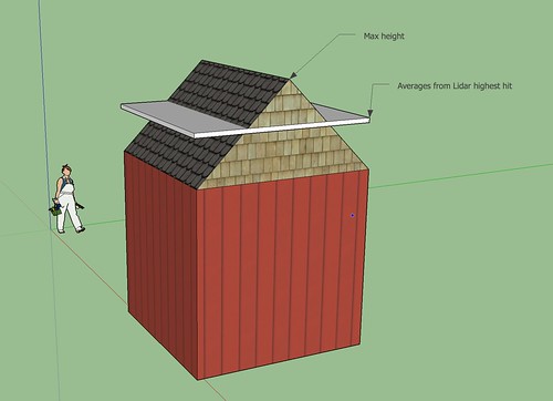
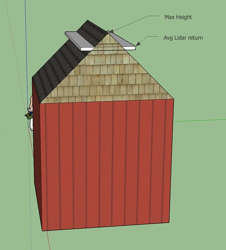
- My concern with roof shapes was more around the inaccuracies introduced by the roof shapes in averaging the lidar. Bdon brings up a good point about "max height" being the number you want. If you are averaging the returns within a footprint of any roof shape other than flat, your height will not be a max height, but rather something in between your max height and the top of your top floor. If this data is ever going to be used for something more than just making a cool looking visualization, that could potentially introduce significant error that would vary for all buildings and could potentially be many feet depending on the roof angle.
- That being said, could you pull the ridgelines by inverting and running a flow accumulation on your clipped LAS? You could then buffer that and average within that smaller poly? Complexity I know, but I think its worth a shot, I'm happy to give it a go.
- It will also be interesting to see what your base height vs building height comes to in some neighborhoods that are more tree-d.
- I like the idea of extracting some roof shapes from lidar, but that might be a bit beyond my ken? I'd love to see how that process would work. If you want to check it out, see file_list.csv for LAZ links and building_footprints2004_intlfeet.shp for the footprints in the repo. There's also a QGIS document in the /demo/ folder that has some work-in-progress data. https://github.com/MaptimeBend/bend_buildings/tree/master/data
- We're going to show the raw raster data and hillshade via an imagery layer in JOSM. Mappers can identify trees and refer to the raw data where buildings are covered, instead of trying to determine the roof height programmatically. The imports committee seems more amenable to this kind of manual process.
- Using imagery layers that mappers can reference is a good idea, as opposed to my "black box" technique. Bdon, how did you generate the raster DEMs and hillshades? I was looking at using point clouds but it's very unwieldy.
- Our source dataset is a GeoTIFF. I styled it and added hillshade in QGIS, then exported to tiles using the tilewriter plugin. Some discussion here. https://github.com/osmlab/sf_building_height_import/issues/5
- It would likely be making too many assumptions to pull out more than the simplest roof shapes from the lidar.
- This is my attempt to illustrate what I'm trying to say about averaging the returns of the footprints. https://c3.staticflickr.com/6/5072/29902968370_b3849d342e.jpg. Depending on roof angle this could yield significant error.
- If we can pull out the ridge tops of buildings based on aspect/slope/whatever and buffer that, the error will be limited to the distance from center x roof angle. https://c2.staticflickr.com/6/5607/29569741593_50790f3280.jpg This being less surface area from the inside out, there is less chance of canopy interference as well.
- Let me know if you can't see my pictures.
- I have updated our wiki page for San Francisco with some evaluation of the LIDAR data vs. street level imagery. San_Francisco_Building_Height_Import
- Discussing in this Talk page is getting a bit unwieldy; you're welcome to join our Gitter channel at https://gitter.im/osmlab/sf_building_height_import