Talk:Attribution guidelines/2020-02-13 draft
Encoding problems
Historically guidance on sufficient attribution has been available from the “Copyright†page on openstreetmap.org (https://www.openstreetmap.org/copyright) and from the OSMF website (Licence and Legal FAQ) .
— Version 1906762 of the Article
There seems to be an encoding problem with all non-(7-bit)-ASCII characters in the wikified version of the document here. (Mostly typographic quotation marks and apostrophes, it seems.) That is all over the document -- the section quoted above is only the first occurence.
--Das-g (talk) 15:00, 22 September 2019 (UTC)
Dropping the word "Contributors"
When the draft of the attribution guideline was first discussed on the lists, Frederik Ramm wondered whether we should drop the word "contributors" from the required attribution text, leaving it just as © OpenStreetMap. Those who responded to his mail were in favour of the change, citing the awkwardness of the current wording, especially in languages other than English.
Has this possibility been discussed by the LWG? Note that the guidelines already allow ©OpenStreetMap "if space is limited". I understand that this is based verbatim on the existing Legal FAQ, but the creation of the guidelines would be a nice opportunity to consider a change. --Tordanik 14:17, 1 October 2019 (UTC)
Attribution on wikis
Can you confirm that the current attribution practices on Wikipedia and many similar wiki projects (including this one) will be considered acceptable? Are they covered by the "small images" wording? --Tordanik 10:54, 3 October 2019 (UTC)
Tordanik - Is it possible for you to provide one or two specific examples with links and/or screenshots? It would help us understand the specific question. --Kathleenlu (talk) 18:01, 10 October 2019 (UTC)
- For an example, consider this map of the Large Hadron Collider. It's used in the Wikipedia article on the LHC, specifically the Design section:
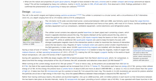
- As you can see, the downscaled "thumbnail" image contained in the article itself does not include any attribution on or adjacent to the image. Instead, clicking on the image shows a full-scale version of the image along with a description text and license information.
- I'm personally OK with this practice and I gather most of the community is, too – in fact, we have explicitly encouraged this manner of collaboration with Wikipedia in the past. I'd say it follows the "in a location where customarily attribution would be expected" principle because all images on Wikipedia, and many other wikis inspired by it, are attributed in this fashion. However, it does not match the explicit guidance on static images, so I wanted to check if this approach to attribution would be in conflict with your intended reading of the new guideline. --Tordanik 16:47, 12 October 2019 (UTC)

Attribution in the credits for video games
I believe video games/simulations should be given similar treatment as fictional movie productions by permitting attribution in the credits as an alternative to the currently mentioned options. Not allowing this seems to contradict the larger "in a location where customarily attribution would be expected" principle, as rolling credits are customary for many gaming genres. (I'm mostly thinking of traditional PC or console games here, not so much of mobile apps.) --Tordanik 10:54, 3 October 2019 (UTC)
Map data downloaded separately from software
What's the guidance on scenarios where software does not ship with OSM data, and does not display online maps, but e.g. allows downloading map data for offline use? Would it be acceptable to make the license information part of the download process, or is it still required that attribution is visible on-screen during use? --Tordanik 10:54, 3 October 2019 (UTC)
Horizontal screen resolutions
This proposal contains several references to specific "horizontal screen resolutions" measured in "device-independent pixels". As an iOS developer, I'm concerned that these guidelines are too easily misinterpreted as hard-and-fast cutoffs. I think it would be better to take a step back and say something that affords the developer more flexibility while meeting the guideline's broader goals. For example, if the one-click carveout for maps narrower than 480 points[n 1] exists for situations where there isn't enough space for persistent attribution, then I think the guideline should be based on whether attribution would take up some percentage of the width of the screen or map without truncation or line wrapping. Calculating the amount of space necessary to display some text can be challenging for developers, but moreso for those drafting legal documents without full context about the device in a given situation.
To illustrate my point, I whipped up a quick test harness to simulate two suggested attribution strings – "© OpenStreetMap contributors" and "Contains data © OpenStreetMap" – in several languages. I varied the text style (font size, leading, tracking) based on Apple's standard constants. At runtime, I varied the device's orientation and accessibility settings. iOS has two accessibility settings that affect text: "Larger Text", which is very popular with older adults,[n 2] and "Larger Accessibility Sizes", which is used by the visually impaired. "Large" is the default size, while AX5 is the largest possible size. All the screenshots were taken on an iPhone SE, the smallest phone supported by modern versions of iOS.
- Footnote
-
 iPhone SE, portrait, Large
 -
 iPhone SE, landscape, Large
 -
 iPhone SE, portrait, xxxLarge
 -
 iPhone SE, landscape, xxxLarge


- Caption 2
-
 iPhone SE, portrait, Large
 -
 iPhone SE, landscape, Large
 -
 iPhone SE, portrait, xxxLarge
 -
 iPhone SE, landscape, xxxLarge
 -
 iPhone SE, portrait, AX5
 -
 iPhone SE, landscape, AX5


- Action sheet
-
 iPhone SE, portrait, Large–xxxLarge

The screenshots above have detailed descriptions on their respective pages. The suggested attribution text has a tendency to overflow, truncate, or wrap in many languages, supporting the carveout. However, the orange bars show that the same would happen in some languages at the proposed cutoffs too. I think a more flexible guideline that doesn't make assumptions about text size would be more effective in the long run.
– Minh Nguyễn 💬 19:54, 10 October 2019 (UTC)
- 1) You should test just "© OpenStreetMap", the recommended link text.
- 2) It is not legally required to enlarge the text of the attribution by the standard ratio when the user selects "Larger Text" options, however, it should be done when possible: the "AX5" examples would be too extreme. But even the xxxLarge "© OpenStreetMap" above is under 180 standard pixels wide (less than 2 inches at 90 pixels per inch). This should be legible to the great majority of users and will fit on even the original iPhone 3.5 inch screen (480 x 320 pixels) in either orientation, leaving room for another logo or short copyright notice on the same line. --Jeisenbe (talk) 05:59, 20 February 2020 (UTC)
Clarity on Machine Learning Section
The guidance as drafted appears to cover a wide range of separate works in a manner inconsistent with the license. There are potential enforceability and other legal risks with attempting to do so. The guidance needs to be more precise to avoid that implication, given this is guidance on attribution and not a general statement interpreting the license in an unexpectedly broad way.
First, are all the headings (books, artwork, etc.) intended to be subheadings to ML? They are organized that way in the document (all subsets of 1.6). That looks like an error, but if it was not, the ML section is even more confusing. As to 1.6 in the main:
"Training datasets derived from OpenStreetMap data are considered Derivative Databases and need to be made available on ODbL terms if publicly used." Please be more precise about "derived." This is to some extent a term of art in US copyright law, but also has a broader lay usage. Data sets could be for example, how much area does this feature cover, or what is the density of streets in this area. These are not map data; they are the numerical results of processing map (and possibly other) data, and they don't include any map data. They would therefore not be "derivative" in the sense of copyright law, but lay readers will likely not understand that.
"Models that have been trained with such training sets are considered Produced Works and if publicly used need to be attributed appropriately." The word "models" is used inconsistently in the industry, but often to mean algorithms, trained programs or new data that is created by feeding in, as input, other data, that then causes the algorithm to be improve in an heuristic way. Any such "models" are separate works and should not be covered by the license at all.
"Note that if a Produced Work is used to extract, copy or recreate substantial parts of the OpenStreetMap data it is considered to be a Derivative Database (see the Produced Work - Guideline)" This seems to contradict the license by equating a Produced Work with a Derivative Database. That is not consistent with the language of the license, which defines the two terms separately.
Is the intent of this section to promulgate an interpretation of ODBL that exceeds both the language of the license and relevant copyright law? If so, I would disagree on principle, given that such an approach is contrary to community practice in the open source community (where, for example, the results of programs are not considered to be works based on the program under GPL). If that was not the intent, then this guidance needs to be clarified, perhaps with examples.
For example, if I use a map database to train a model to forecast sales of cars, or stoplights, asphalt, or anti-gravity hoverboards in a particular city, and the result is a copyrightable software program or narrative report or set of data, none should be considered derivative. Those are, to the extent they are copyrightable, independent works not covered by the license.
There are those in the industry who are trying to grapple with whether the copyleft model can be applied to ML. That is a complex discussion that is in its infancy. I am suggesting you might not want to tackle it in this guidance, which seems addressed to a narrower purpose.
—Preceding unsigned comment added by Hmeeker (talk • contribs) 20:13, 10 October 2019 (UTC)
"horizontal screen resolution of less than 480 device-independent pixels" - which devices would be covered by that?
Is it small enough to cover just smartwatches and similar? Is there chance that it would allow unreasonable hiding of attribution on a standard smartphones? Is there somewhere overview what kind of devices would be covered here? Mateusz Konieczny (talk) 14:15, 13 December 2019 (UTC)
- For an example see https://api.mapbox.com/styles/v1/mapbox/streets-v9.html?title=true&access_token=pk.eyJ1IjoibWFwYm94IiwiYSI6ImNpejY4M29iazA2Z2gycXA4N2pmbDZmangifQ.-g_vE53SD2WrJ6tFX7QHmA#16.5/50.056731/19.945845/-7.8 that is breaking odbl by not dissipation an attribution on my smartphone. This osm-hiding technique should be clearly forbidden, also on smaller screens. Even on smartwatch sized screens it should be possible to fit "© OSM" Mateusz Konieczny (talk) 06:12, 30 December 2019 (UTC)
- On the Talk mailing list, SimonPoole (LWG member) argued that we should not allow "© OSM" because the first search result for this is Online Soccer Manager (Openstreetmap.org is the second search result on several major search engines). This is probably reasonable, but "© Openstreetmap" is only 15 characters long: it is legible at 100 pixel width on standard resolution devices, and at a slightly smaller size on high DPI / high resolution / "retina" screens with 2x or 3x pixel resolution. Therefore, it is reasonable to expect attribution with "© Openstreetmap" when the map is wider than 200 standard pixels: here the attribution will only take up half the width of the screen at the bottom, leaving plenty of room for a second copyright notice or logo. --Jeisenbe (talk) 23:05, 19 February 2020 (UTC)
- Obviously, in all cases where "© Openstreetmap" can be shown it should be used - for example on a typical smartphone or other mobile computer. I though about "© OSM" for smartwatches where fitting readable "© Openstreetmap" may not be possible Mateusz Konieczny (talk) 19:31, 20 February 2020 (UTC)
Attribution should always be required on the map, no splash screens or clicks, if any logo or copyright or attribution can be shown.
Attribution should always be required 1. on the map 2. in high contrast
The main problem with the new draft is that mobile devices, which are by far the most common ways of accessing maps around the world, are only required to provide attribution after a click or swipe, or even just on app startup with a short "splash" screen:
"mobile devices may have attribution after one interaction. Examples of one interaction include “one click,” such as an icon or link that opens a pop-up or new webpage, or a swipe, drag, pinch, etc." "Alternatively, mobile devices may provide attribution on a splash screen on application startup or in a pop-up that fades/collapses automatically." https://wiki.openstreetmap.org/wiki/Draft_Attribution_Guideline#Mobile_devices
This is the case even if the map takes up the whole, high-resolution screen and there is plenty of room for a Maps.me or Mapbox + ESRI + App logo in the right hand corner. I do not consider this reasonable, or the excuse for "max 25% of displayed window": that could be up to 1400 x 800 pixels on my laptop.
Ghere should be a statement in the guideline that Openstreetmap attribution should be equal to that given to other data sources and the map or app designer. / owner. That is, if the app logo or aerial imagery copyright is shown, then Openstreetmap should be shown at the same time. If Openstreetmap is relegated to a separate splash page or linked page, the other copyright/logo features should also be on that page. This is need to prevent misrepresentation of the map data as being from a different data provider, or as belong to the app / designer.
We should not give up on enforcing basic ethical behavior from corporations. Everyone who has been to school knows that copying without attribution is plagarism, and putting your logo and copyright on the front makes it look like plagarism if Openstreetmap is relegated to a non-visible page. --Jeisenbe (talk) 13:44, 19 February 2020 (UTC)
What is the attribution for Carto tiles?
The Guideline does not make clear how to attribute Carto tiles. At Attribution text it says that the map style is under CC0 and that I should use (c)OpenStreetMap as attribution. At “Standard” style map tiles it says I should use Base map and data from OpenStreetMap and OpenStreetMap Foundation -- Discostu36 (talk) 15:02, 19 February 2020 (UTC)
Different standards for Tablets vs Mobile phones are not legally or logically defensible
Current full-size mobile smart phones are as large as small tablet devices. For example, the Galaxy Note 10 plus is 162.3 mm x 77.2 mm x 7.9 mm with a 91.66% screen ration: The screen has a resolution of 1440 x 3040 pixels and 495 ppi pixel density. The iPhone 11 Pro Max has a 6.5 inch screen with 2688×1242 pixels (3.3 megapixels at 458 ppi). In comparsion, the Kindle Fire HD tablet has been sold with 6, 7, and 8 inch screens with lower resolution. All these devices use a touch screen (and a small number of buttons) for controls. The iPad mini has an 8 inch display, not substantially larger than the 6.5 inch large-format smart phones.
Considering this, I don't see how we can ask for different attribution guidelines for tablets versus smart phones without considering screen size, as phone screens continue to grow larger.
Rather than basing the exceptions which allow attribution after a click/swipe or on a splash screen to be valid for mobile devices but not for tablets, the guidelines should be changed to be based entirely on screen size. Therefore, an app used on a smart watch or other tiny device with a 1.3 to 2 inch screen should be allowed to show attribution on a splash screen at startup, and then after a click/swipe while using the map. Similarly, apps for small mobile phone screens (for example, the "non-smart" phones sold in developing countries) with screen size under 3 inches can be allowed to keep the attribution after a swipe or click, since a 2.25" by 1.75" inch screen would be too small to display
But a 3.5 inch smart phone screen (such as the original 2008 iPhone) with a 320 x 480 pixel display is already plenty wide enough for "© OpenStreetMap" - which only needs 80 standard pixels of width at 10 point font. Therefore, smart phone apps for >3 inch displays should show the attribution in the lower right corner, the same as maps on websites and printed maps. --Jeisenbe (talk) 05:31, 20 February 2020 (UTC)
Allowing Mapbox-style attribution hiding is bizarre and unacceptable
"In addition, mobile devices may have attribution after one interaction." - this is not OK. Nearly noone is tapping hidden parts of the interface. And ODBL requires making all users aware of the license. Mateusz Konieczny (talk) 19:28, 20 February 2020 (UTC)
Future-proofing "Small Maps"
Regarding what is considered "small", computer screens tend to get bigger, and smartphone screens as well. A "displayed window" may be very large (and 500 dip is already very large anyway). How about:
"Maps are considered small if the attribution does not fit into one half of the map's width"
So, this is independent of any window size and also independent of any fixed pixel width, but only dependent on whether there is enough horizontal space for the attribution text to fit into the lower right corner of the map, which this is about after all. Could be also a different value than one half, i.e. one third etc.
Also, this solves the problem brought up by Minh Nguyễn about what if the user increased the font size in the system accessibility settings.
Also, it solves the "Map provider shows attribution to himself but not to OpenStreetMap", because with >480dp horizontal space, there is still plenty of space to show f.e. "powered by Mapbox" and nothing in the current draft attribution guideline forbids still showing the own attribution. The suggestion above refers to whether the attribution fits or not, not some arbitrary pixel width. And of course, if it doesn't fit because the map provider chose to display the attribution in huge letters, then his own attribution will also not fit.
In any case, the first point of the definition of "small" ("The map takes up less than 25% of the displayed window") should be dropped. It is covered by the second point already and as said, results in unexpected guidelines for big screens. The second point is easily implementable with CSS, the first point, less so. --Westnordost (talk) 10:16, 22 February 2020 (UTC)
- Here is a link of a news site reporting of the route of a rally that currently attributes correctly but wouldn't need to show the OpenStreetMap contribution directly under this new guideline. It seems, with the current definition of "small maps", the situation would in any case get worse.
- https://www.ndr.de/nachrichten/hamburg/Fridays-for-Future-in-Hamburg-Tausende-demonstrieren-mit-Greta-Thunberg,klimademo176.html
- (Screenshot if the link will not be available anymore: https://framapic.org/bNqie7E9cxAo/HMCACtCiRX6U.png )
- As you see, the attribution text easily fits into the map, it only takes up about one forth of the horizontal space, yet, the map width is barely above 500px. But, more importantly in this case, if you enlarge the browser window large enough (i.e. on full screen on a large screen), the map would take up less than 25% of the displayed window. --Westnordost (talk) 11:08, 22 February 2020 (UTC)
Comparing with industry practice
Sources of map data are typically deeply hidden (for example Google is deeply hiding real data sources for their maps). But is there any other dataset that is seriously used for map display that requires attribution? Is there any other dataset that has attribution requirements comparable to ODBL ("reasonably calculated to make any Person") and is widely used for producing maps?
I am curious whatever OSM is unique, and whatever there are other data sources with both comparable attribution requirements and with at least some real use. Mateusz Konieczny (talk) 21:48, 12 March 2020 (UTC)
Attribution should not be optional
The section about mobile maps says attribution could be hidden after "one interaction", but we all know where this will end. It's not a secret that it was an idea suggested by one of OSM's corporate users, as seen in the LWG meeting minutes from February:
1-user interaction: suggestion from a company to have a side swipe for this, as this is what users are expecting. Maybe add a note to that effect.
I've already started a discussion in the Talk mailing list and was surprised to see who's pushing for hidden attribution and it's shocking to see some veteran OSM members defending this harmful, corporate view. As was discussed in the thread mentioned before, let's follow the example of Mapbox. If you use Mapbox, you are required to add attribution via text and a watermark. If you use your own data with Mapbox's tiles, you are required to add their watermark to the map. If you use Mapbox data and tiles, you are required to add both forms of attribution: watermark on the bottom-left corner and text on bottom-right. If you use their data, you are also required to add visible attribution to the map. So, why does OSM have to be different, why does it have to be so passive, allowing corporations to freely use data that was gathered and imported by thousands of volunteers that spent countless hours in making OSM what it is today, without caring about attribution?
I've proposed a thought exercise in the thread: a map is a visual representation of data. Without data, you won't have a map. If we take a look today, a tile is a visual representation of the map's data, meaning it's the most important part of the map. Why do I have to add a giant Mapbox watermark on my map if the underlying data is much more important than the visual service Mapbox provides? It should be the opposite, OSM should always have a preference over tile service watermarks and attribution text because, without the data, you wouldn't have a tile to represent it.
Hiding attribution under one interaction, as proposed by a company, is harmful to OSM. Firstly, because users won't interact with the button or GUI element. Secondly, because all examples we have so far include an info button that's clearly not visible enough to draw attention to it and users barely notice it on the map.
Bringing up another topic mentioned in the LWG meeting minutes from March:
Attribution by default could be adopted by the community as "reasonably calculated" for websites/apps, if visible for 5-10 sec and then collapses in a way that the user can reopen it.
No practical objection for disappearing attribution, if OSM is the single source.
I don't know where this info was taken from but from the thread I started in the mailing list I can see that it's not commonly accepted by the community. True, we have mappers that don't care at all about attribution, but those who are concerned about lack of attribution certainly wouldn't accept "disappearing attribution" or showing attribution for 5-10 seconds. This contradicts what was mentioned earlier in the same meeting minutes:
Splash screen suggested as a solution. But one could argue that once it's gone, we're no longer fulfilling the literal requirement of ODbL.
As mentioned by Jeisenbe, copying without attribution is plagiarism. I don't know why there are non-corporate members endorsing company suggestions to make attribution ineffective.
--Aoalmeida (talk) 16:51, 19 May 2020 (UTC)
- What company? If it is a verifiable fact, and not speculation, it's fair to call its name --Westnordost (talk) 18:03, 19 May 2020 (UTC)
- I can't say for sure because I didn't participate in the meeting minutes, but it's something the LWG can say, I guess. The meeting minutes just mention a company, not identifying who suggested it. --Aoalmeida (talk) 14:04, 22 June 2020 (UTC)
- What company? If it is a verifiable fact, and not speculation, it's fair to call its name --Westnordost (talk) 18:03, 19 May 2020 (UTC)