Talk:OSM2World
Known issues
The "TerainBoundaryAABB" debug view does not work.(fixed in 0.1.1)handling of multipolygons with more than one hole is buggy(fixed in 0.1.2)
A current list of known issues can be found on the GitHub issue tracker.
Debian
Great work, Tordanik!
Just a hint: for running OSM2World on Debian Linux, I have to install libjogl-jni and extend the java library path as in java -Djava.library.path=/usr/lib/jni/ -jar OSM2World.jar. --Scai 20:06, 24 November 2011 (UTC)
- Thanks for testing OSM2World, that information could be useful for other Debian users. Can you describe what kind of error you get when running OSM2World with the bundled native jogl libraries (lib/jogl/linux-amd64 or lib/jogl/linux-i586, depending on your architecture)? --Tordanik 22:25, 24 November 2011 (UTC)
- None, I just didn't see the shipped libraries and the ./osm2world.sh script. Works great :) --Scai 09:53, 25 November 2011 (UTC)
Tags
It would be nice to have a list of recognized tags, especially for building attributes.
A related question regarding the building roof: why do you evaluate roof:ridge instead of the documented building:roof:ridge? Also there seems to be a problem with building=entrance nodes disturbing the roof shape.--Scai 19:05, 25 November 2011 (UTC)
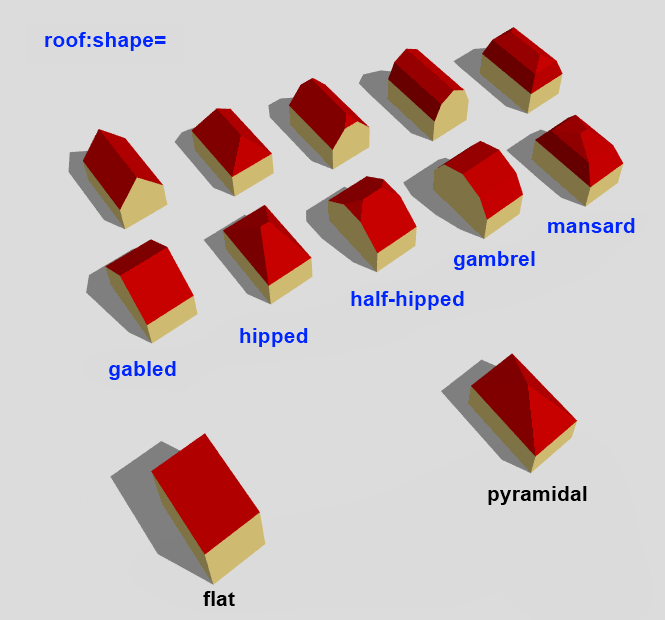
- What I can offer is this semi-automatically generated taglist. Because of the way it is generated, tags are often not listed individually, but only with their common key. This picture shows the roof shape values (minus "onion") supported by OSM2World. I hope I get around to providing more detailled documentation of supported tagging some time.
- About the "namespace" issue: I'm currently discussing the building attributes with another developer and OSM2World will probably end up supporting building:roof:* tags in the near future (even though building:roof:ridge:direction is awfully long...). After all, they are more popular in the database and with other applications.
- Finally, you are right about the entrance nodes. Some roof shapes, particularly those mapped with ridge and edge ways, are still quite buggy. --Tordanik 22:45, 26 November 2011 (UTC)
- Good to know. I understand that there are still lots of open questions regarding 3D objects and their tagging. --Scai 09:12, 27 November 2011 (UTC)
2017 update: The taglist file linked as part of this discussion is no longer current. If you're looking for a list of tags supported by OSM2World today, I recommend browsing OSM2World's Taginfo project entry. --Tordanik 15:35, 26 November 2017 (UTC)
GUI
Although I understand that the GUI is primarily for debugging, I wonder if you would consider the following small enhancements:
- it would be great to have a dashboard, showing current height above ground, lat/lon location, direction of view and angle of head
- the keyboard controls are much more intuitive and easy than the mouse (I will add them to the wiki as I had to experiment to find them). Please note that +/- is not a good choice as these keys move around on international keyboards. On my UK keyboard, + is shift-= as doesn't work. Finally, there is no keyboard control for head tilt, I have to use the right mouse button for this. Would it be possible to add?
Really nice to have but probably more work:
- a map view showing a mapnik tile with user's location on it (this makes more sense when the user is at "ground level" alongside the 3D view
- dynamic loading of small areas, directly from OSM as the user moves around
- click on a item to show its tags
- offer a shortlink to "edit this in OSM"
Thanks for this - it is a great tool with lots of potential to bring OSM3D to life. OliverLondon 22:18, 6 May 2012 (BST)
- I appreciate your feedback and all of your ideas would make nice features (even though some stray quite a bit from "debugging interface" into "end user application" territory). Those features that require knowing the user's lat/lon location are currently held back by the unfinished projection implementations, but it will be straightforward to add them once that issue is solved.
- The keyboard controls are mostly undocumented because there isn't much of an underlying design context behind them, aside from trying to allow for keyboard+mouse control as well as two hands on the keyboard, and I'll readily shuffle them around if there are better ideas. Do you have any alternative suggestions for +/- as zoom keys? --Tordanik 14:47, 12 May 2012 (BST)
Thanks for this great tool - I've been using to show my kids what can be done with Open Data :-) For this purpose it would be very nice to have the roof:colour display more values, e.g. brown. Would'nt it be possible to use exactly the colour the tagger has entered?! Thanks!
- Depending on which of the many available colour name translation tables you use, "brown" might be very different colour. That's why I have refrained from adding a large number of words for colours until now, and pointed out the ability to add RGB triples as colour values. However, Kendzi3D has now added one such list of colour names, so I'm considering to use the same one. --Tordanik 20:52, 22 September 2013 (UTC)
Darstellungsfehler an Kreuzungen
Hallo, mir sind in letzter Zeit in meiner Gegend immer wieder seltsame Darstellungsfehler in der Slippy Map aufgefallen. Beispielsweise werden hier oder hier statt Kreuzungen Rechtecke im 45°-Winkel gezeichnet und an anderer Stelle versinken ganze Felder im Nichts. Ist da etwas falsch getaggt oder liegt der Fehler an OSM2World? --AndreR (talk) 21:13, 29 May 2013 (UTC)
- Die fehlenden Texturen (schwarze Felder) sind ein Server-Problem, das nach zu langem ununterbrochenen Betrieb auftritt - dafür gibt es bereits einen Bugreport, aber noch keine Abhilfe. Die Kreuzungen sind hingegen ein Bug direkt in OSM2World, der vor allem bei sehr spitzen Winkeln an Kreuzungen vorkommt. Grund ist die recht primitive Kreuzungsberechnung, bei der die Fläche der Kreuzung so lange in alle Richtungen vergrößert wird, bis keine einmündenden Straßen sich mehr gegenseitig überlappen. Bei diesem Link von dir ist das aber z.B. bei den beiden nördlichen Straßen erst sehr weit vom Kreuzungsnode entfernt gegeben. --Tordanik 00:20, 30 May 2013 (UTC)
- An, danke für die Info. Gibt es da denn schon Pläne, das zu überarbeiten? --AndreR (talk) 18:51, 30 May 2013 (UTC)
- Nichts konkretes. Ich würds gern mal angehen, aber man hat immer so viel anderes zu tun ... will daher nicht zu viel versprechen. --Tordanik 21:50, 31 May 2013 (UTC)
OSM2World crashes on my laptop
When I will create a 3D rendering in OSM2World in my laptop, the program crashes for the latest version, but I am not sure for the older versions, which is more stable. Is OSM2World crashing upon download of .osm data an issue?--TagaSanPedroAko (talk) 19:44, 29 December 2016 (UTC)
- Is there any error message? If not, can you try to run OSM2World from command line and send me the command line output? --Tordanik 22:03, 29 December 2016 (UTC)
WebGL version
I just saw your SotM talk about the WebGL version. Is there a way to get notified when it launches? Discostu36 (talk) 20:17, 22 November 2019 (UTC)
- Hi, thanks for your interest! Putting the wiki page OSM2World/WebGL client on your watchlist should work, I expect to update it when it launches. Of course, I hope the launch will make enough of a splash to show up in Wochennotiz/WeeklyOSM and similar OSM channels, so if you follow these news, you should learn of it that way, too. --Tordanik 21:55, 29 November 2019 (UTC)