User:Orion osm/Sandkasten
Large forest areas need to be subdivided for forestry management: these subdivisions are usually termed compartments. Their size may depend on the nature of the forest products, but they will always reflect a size which represents a reasonable unit or work (selective felling, clearing brush wood, coppicing etc). From compartments already mapped on OSM a maximum size appears to be 4 sq. km, with traditional mediaeval coppice panels in England being only a few hectares.
Given the uniformity of many forests these units have traditionally been marked on the ground by boundary markers (attached to trees or as posts) showing a unique identifier for the compartment. As leisure activities have increased in forests these markers have proved to be very useful navigation aids. It is probably this latter point which is of most interest to OSM mappers and users.
FAO Definition
Taken from Guidelines for the management of tropical forests section 1.1.1:
A compartment is a permanent, geographically recognisable unit of forest land forming the basis for planning, prescription, implementation, monitoring and recording of forest operations. To the extent that it is practicable, areas of forest that are to be managed for different purposes, or have clearly different functions or values, should be placed in separately defined compartments. A compatibility matrix of forest functions that can be used as a guideline for determining compartment functions is shown in Tables 5 (a) and (b).
Practical guidelines for defining forest compartments are:
- Wherever practicable:
- Boundaries should be geographically recognisable, such as rivers, streams, ridges and gullies. Permanent roads and trails may also be used. Boundaries should be recorded on all forest management maps.
- Compartments should as far as possible comprise uniform forest types and be physically recognisable on the ground.
- Numbering should be sequential, usually commencing at a forest headquarters. Compartment numbers should not be changed.
- Compartments should not be so large that sub-division into numerous sub-compartments is required in order to achieve effective implementation of forest operations. Sub-compartmentation should be minimised. Flexibility is required in determining compartment size; a practical size range for many management situations is between 100 ha and 500 ha, depending upon the physical features of the forest and land.
Examples
France
Large forests, particularly those also used for leisure, tend to divided into compartments based around a regular network of rides and forest roads. In the ![]() Forêt de Fontainebleau the network consists of rides radiating from certain points in the forest (carrousels). The compartment number if shown at each junction bounding the compartment.
Forêt de Fontainebleau the network consists of rides radiating from certain points in the forest (carrousels). The compartment number if shown at each junction bounding the compartment.
Poland
Polish forest data imported from often has an identifier associated with each forest compartment of the form: "02-36-1-09-20 - -" (see 228402932![]() 228402932. Only the latter 2 groups are used for marking compartments on the ground. The complete form is tagged with adr_les=*. The leading elements represent higher level units in the national forest administration.
228402932. Only the latter 2 groups are used for marking compartments on the ground. The complete form is tagged with adr_les=*. The leading elements represent higher level units in the national forest administration.
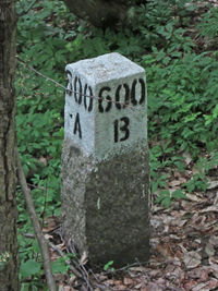
Example: 600A/600B, a marker post in ![]() Białowieża Forest near
Białowieża Forest near ![]() Topiło represents two square compartments half a
Topiło represents two square compartments half a ![]() verst on each side.
verst on each side.
Russia
- КЛ - колхозный лес : a collective farm forest
- СЛ - совхозный лес : state farm forest
- ГЛ - государственный лес : state forest
- ПП - пробная площадь: test area
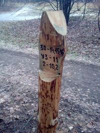
- Example
- Line 1: 30-14,15,16 - 30 in the quarter, Mark 14,15,16
- Line 2: KM 11 - KM "Cleaning cluttering" 11- 2011
- Line 3: 2-10,2 - plot №2, an area of 10.2 hectares.
OST 56-44-80
- пример
- строка 1: 30-14,15,16 - в квартале 30, выделах 14,15,16
- строка 2: УЗ-11 - УЗ "Уборка Захламленности", 11- 2011 год
- строка 3: 2-10,2 - делянка №2, площадь 10,2 га.
ОСТ 56-44-80
Germany
Basically all forests are subdivided into compartments, in German so-called "Abteilung". they are signed usually at their corners, at the junctions. The design of the signs largely depends on the region, but typically they contain the administrative region, a number and a name. An example is given in the picture to the right.
How to map
Usually map as a relation incorporating the relevant sections of natural and man made features typically used to delineate the forest compartment. These will usually be tracks, roadways, paths, water features, and cutlines. More rarely they might be fences, or not marked on the ground at all.
Add the identifier as ref=* and add a name if relevant. Some very old traditional compartments may only have a name.
It is not always possible to delineate the size of the compartment on an initial survey. In this case merely map the surveyed boundary markers and assign the ref=* to these nodes. Usually it will become apparent fairly quickly what the overall scheme for compartmentalisation of any given forest might be. For instance historic forests in the former Russian Empire often have a rectangular grid based on 1 verst.
Rendering
See related discussion on the CartoCSS github project.
Related tags
The close synonym boundary=forestry_compartment is used 2-3 times less than the tag documented here.
A small number of cases exist of boundary=forest used for compartments, but this tag is better reserved for things like Forêts Dominales (in France).
For the actual markers use man_made=boundary_marker or historic=boundary_stone. An additional tag boundary_marker:mounting=* can be used to indicate those markers which are attached to other objects (trees, guideposts etc).
See Also
- man_made=cutline A line cut in the forest for access or aa a
![Wikipedia [W]](/w/images/2/24/Wikipedia-16px.png) fire break. Cutlines are often on compartment boundaries.
fire break. Cutlines are often on compartment boundaries.
Other discussions
On the russian language forum, google translation to english here


