Tag:boundary=forest
 |
| Description |
|---|
| A mostly wooded area with explicit boundaries |
| Group: top-level |
| Used on these elements |
| Useful combination |
| See also |
| Status: approved |
| Tools for this tag |
A delimited forest is a land which is predominantly wooded and which is, for this reason, given defined boundaries. The lands inside the boundaries are often subject to different rules than the surrounding lands. The delimited area is typically named, and have materialized, visible, typically cleared, boundaries. It may cover different tree stands, non-wooded areas, highways… but all the area within the boundaries are considered and managed as a single forest.
Identifying delimited forests
Though delimited forests are mainly wooded, they are not totally so. Delimited forests may contain screes, ponds, scrublands, or grasslands which are not covered by trees, and are consequently not tagged as wooded areas. Such non-wooded areas are still part of the delimited forest, as they may be:
- managed by the manager of the delimited forest;
- under reforestation;
- lands with a distinct, wood-related ecosystem (glades for instance, which essentially exist because they are in a wooded area, else they would be called grasslands);
- legally considered part of the surrounding forest, i.e. they are subject to the same subset of laws, rights and obligations (
 Régime forestier in France, for instance).
Some forests may even be predominantly scrubland (natural=scrub), which often forms after a clearcut followed by natural regeneration (i.e., no plantation). In this case, the land will not be again tree covered until the seedlings grow, which can take decades.
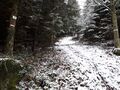
Here are some examples of delimitation of forests and forests compartments in France:
-
 Compartment in a forêt domaniale. The sign gives the name of the forest and the compartment ref. The white paint mark is regularly painted along compartment borders to materialize it.
 -
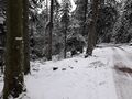 Paint markings along a compartment border; the marks are painted on the outside of the trees at the limits of the compartment, to indicate that you are entering the compartment. The compartment whose limits are indicated here is on the left of the picture.
 -
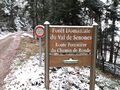 Sign at the boundary of a forêt domaniale; those signs can also give the name of the track, as here.
 -
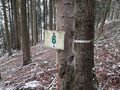
 Forestry compartment boundary; this one is typical, with a compartment ref sign, and a cutline along the boundary with painted dashes on the trees of both compartments.
 -
 Another compartment boundary: the sign indicated that it is the boundary of the #6 compartment of the Forêt communale de Denipaire. Once more, the painted dash indicates the boundary.
 -
 Another compartment boundary, at a corner: the boundary runs from the boundary stone to the tree, then goes on the right.
 -
 A boundary stone at a compartment tripoint: the three boundaries are indicated with paint.
 -
 Another compartment boundary stone; they can also be simply painted like this one, without explicitly drawing the boundary with painted lines. Compartment does not always have boundary stones either, not by any means.


Boundaries
A wild wooded area is considered a delimited forest when its limits are clearly materialized, for instance with paint, boundary markers, or cutlines.
The markings used to delimit forests are more significant than the standard markings used for common land lot boundaries. Standard land ownership boundaries in wooded areas typically lack signs, marks or paint highlighting the difference between wooded area boundaries and non-wooded area boundaries, but local laws and customs may prescribe carved marks or other methods for the materialization of delimited forest boundaries. If a wooded area is only delimited with land lot boundary stones, without any signs, marks or paint highlighting the difference between its boundaries and standard land lot boundaries, the area should not be modelled as a delimited forest.
Forestry activities
This tag is not about forestry activities: delimited forests may be the place of forestry activities, but this is not necessarily the case. Materialized boundaries may be mandated by law, current practices or necessity, but do not necessarily imply that the encompassed area is subject to forestry works.
Forests vs protected areas
Delimited forests and protected areas may overlap or coincide. If they overlap, they can be modelled separately, with a boundary=protected_area entity and a boundary=forest entity.
In some cases, though, a delimited forest may also be a protected area (most likely, IUCN Category VI): for instance, in France, the Réserve Biologique Dirigée (RBD) and Réserve Biologique Intégrale (RBI) can legally only encompass public forests, which are always delimited forests. In such a case, the facts that the area is, on one hand, a forest, and, on the other hand, a protected area, cannot be separated.
In the case that a whole delimited forest is also a protected area and these two characteristics apply to the same entity (a RBD/RBI, for instance), they must be mapped with a unique OSM entity, which would be tagged with boundary=forest + protect_class=*, consistently with the tagging scheme for IUCN Category II national parks (tagged boundary=national_park + protect_class=2). It is appropriate to also tag this entity with other relevant tags commonly used with protected areas, such as related_law=*, access tagging, or leisure=nature_reserve if applicable, to reflect the dual status of the area.
If, on the other hand, the protected area and the delimited forest exactly encompass the same area but are distinct features (that is to say, the legal protection status of the area is not attached to the area being also a delimited forest), they should be mapped with separate entities: a boundary=forest entity for the forest, and a boundary=protected_area for the protected area.
Areas named "forest"
The fact that an area has the word "forest" in the name does not necessarily mean that the area should be mapped with the proposed tagging scheme: the wooded state of the land must be a predominant characteristic, and there must be defined boundaries. For instance, US National Forests have mostly unmaterialized boundaries, and are consequently not in the scope of the proposed tagging scheme.
Named natural forests, such as Germany's ![]() Black Forest, are indeed large wooded areas which are considered as a unique forest, but they lack clear boundaries, are not effectively managed as a whole and, as such, do not qualify for the proposed tagging scheme.
Black Forest, are indeed large wooded areas which are considered as a unique forest, but they lack clear boundaries, are not effectively managed as a whole and, as such, do not qualify for the proposed tagging scheme.
Some specific cases
Here are some special cases where the applicability of the approved boundary=forest relation may need clarification.
| Case | Applicable? | Why? |
|---|---|---|
| Illegal agricultural deforestation area | No | It most likely lacks precise boundaries, which are a prerequisite to be modelled as boundary=forest. In addition, once the deforestation is started, the area likely does not keep its wooded state for long and is thus out of scope for OSM.
|
| Legal forestry concession with illegal logging | Yes | Even if the logging is illegal, the area is wooded, and the concession should have verifiable boundaries. Of course, if the area becomes totally, permanently deforested, without letting natural regeneration take place or replanting, the area is no longer a forest. |
| Wooded land without verifiable boundaries | No | If the area limits are not verifiable, it should not be modelled as a boundary=forest relation.
|
| The |
No | Even if it is a predominantly wooded land, which is commonly known as a whole, single wooded area, its boundaries are neither distinct nor verifiable, hence disputable, so it is not to be modelled with a boundary=forest relation. That being said, the underlying physical, wooded lands themselves are still eligible to modelling with natural=wood/landuse=forest.
|
| Mostly wooded area without verifiable boundaries | No | The area is predominantly wooded, but its boundaries are unverifiable. |
| A unique, whole area with verifiable boundaries and predominantly wooded, but fragmented in distinct, separate areas | Yes | If the fragmented area is still considered in its entirety as a unique delimited forest, then it is to be modelled with a unique boundary=forest relation, which would enclose all the separate pieces of wooded land; use natural=wood/landuse=forest for the physical wooded land.
|
| A wooded area with distinct existence and verifiable boundaries, which contain screes and glades | Yes | The boundary's verifiability and the area being predominantly wooded qualifies it for a boundary=forest relation. As this relation is about delimited forest boundaries, if the screes and glades are considered part and parcel of the delimited forest, the relation will not treat them as exclaves of the said delimited forest. These non-wooded areas are to be mapped by their own entities, and the wooded land around with natural=wood/landuse=forest entities; once again, do not overlap natural=wood/landuse=forest entities and non-wooded entities.
|
| A wooded land lot whose boundaries are mere boundary stones | No | The materialization of boundaries in a way which is distinct of standard land lots is required to prevent importing mere cadastral data; use landuse=forest or natural=wood without boundary=forest, which is not designed to allow importing plain cadastral data.
|
| A wooded land lot whose boundaries are marked in a way distinct of adjacent land lots | Yes | The materialization of boundaries in a way which is distinct of standard land lots is enough, unless you are sure the specific marks used are unrelated to forests. |
| A US National Forest | Likely, no | Typically, US National Forests have no materialized boundaries, so they are not in the proposal scope. |
Note regarding boundary materialization
The approved proposal mandated the materialization of boundaries, out of verifiability concerns. That being said, some contributors, in vote comments, on the Talk page of the proposal or in the various preliminary discussions, explained that in their country, forest boundaries are not materialized out of practical reasons, for instance lack of funding, like in some African countries.
Though some sentences which follow do not meet the approved definition of this tag, it may happen that you want to map a forest corresponding to the above definitions, with the difference that its boundaries are not materialized but are still verifiable according to local laws and practices; for instance, the boundaries are published, and this publication is generally acknowledged by local people, societies, enterprises, authorities… as a legitimate, verifiable source. In such a situation, this source could be considered verifiable enough to allow mapping the forest. Be advised, though, that this appreciation may be challenged by mappers having stricter criteria of verifiability, i.e. requiring boundary materialization.
How to map
A delimited forest should be mapped as follows:
- The overall delimited forest should be mapped as an enclosing polygon or relation. Do not add land cover tagging (such as
natural=*) to this boundary or "cut out" minor non-wooded areas such as ponds or screes that may be present. - A delimited forest may include smaller delimited forests, themselves either divided or not in compartments, so a
boundary=forestentity may enclose smallerboundary=forestentities. - Natural features (such as
natural=wood,natural=water,natural=scree, etc.) should be separately tagged with their own polygons delimiting actual areas where these features are present, and as an inner multipolygon member of the enclosingnatural=wood/landuse=forestfeatures if they are not wooded. Woodland-specific tagging such asleaf_type=*,leaf_cycle=*, etc., should be tagged onnatural=wood/landuse=forestfeatures.

natural=wood) and the overall delimited forest entity (tagged boundary=forest); the pond is considered part of the delimited forest and therefore included in it.The overall delimited forest (entity tagged boundary=forest) can be tagged as follows:
| Key | Value | Discussion |
|---|---|---|
type=*
|
boundary
|
Mandatory if the entity is a relation [1] |
boundary=*
|
forest
|
Mandatory |
name=*
|
The forest name
|
Recommended. If applicable, the delimited forest can be named with this tag, and, maybe, its subtags, like name=Forêt de Fontainebleau or name:de=Wald von Fontainebleau.
|
ref=*
|
The forest ref
|
Optional. Such reference is probably country-based, so one should use a subtag, like ref:FR:ONF, whenever applicable; the choice of this subtag for a given country is up to the local OSM community.
|
operator=*
|
The forest operator
|
Optional. |
owner=*
|
The forest owner
|
Optional. |
operator:wikidata=*
|
Wikidata ID
|
Optional. Use for giving the wikidata ID of the operator; for instance, a French forêt communale, mandatorily managed by the national Office National des Forêts, would be tagged operator:wikidata=Q3260938.
|
owner:wikidata=*
|
Wikidata ID
|
Optional. Use for giving the wikidata ID of the owner; for instance, the French forêt communale d’Épinal, owned by the commune d’Épinal would be tagged owner:wikidata=Q173695.
|
source=*
|
The source used
|
Optional. |
protect_class=*
|
Protection class ID
|
Optional. Use if the delimited forest has also been designated a protected area as defined by IUCN protected area categories, and if the protected area and the forest form a single entity. |
protection_title=*
|
The forest owner
|
Optional. Use if the delimited forest has also been designated a protected area as defined by IUCN protected area categories, and if the protected area and the forest form a single entity. |
related_law=*
|
The related law
|
Optional. Use for giving the title of the edict or legal text which establishes or regulates the delimited forest. |
leisure=*
|
nature_reserve
|
Optional. Use if the area is also a nature reserve; if there are access restrictions, don't forget to accordingly add access keys on the highways allowing access to the area.
|
On encountering a natural=wood/landuse=forest (multi)polygon representing a delimited forest
- Enclose the overall delimited forest in a
boundary=forestentity (area if relevant, relation otherwise) with the relevant tags (name,operator…) which you may borrow from thenatural=wood/landuse=forestentity if relevant - Keep the actual wooded areas with
natural=wood/landuse=forest
Examples
French forêt communale
The forêt communale de Chauffecourt would be modelled by an entity (area or relation) tagged this way:
type=boundaryif the entity is a relation [2]boundary=forestname=Forêt communale de Chauffecourtoperator=Office national des forêtsoperator:wikidata=Q3260938owner=Commune de Chauffecourtowner:wikidata=Q223406- the physical land would be modelled with separate
natural=wood/landuse=forestentities with tags modelling the physical forest, such asleaf_type, or otherlanduse/naturalentities according to physical state of land. These non-wooded entities would not overlap thenatural=wood/landuse=forestentities (non-overlapping polygons or inner multipolygon members).
German state forest
The Einsiedler Wald relation would be tagged this way:
type=boundaryif the entity is a relation [3]boundary=forestname=Einsiedler Waldowner=Freistaat Sachsenoperator=Staatsbetrieb Sachsenforstowner:wikidata=Q1202- the physical land would be modelled with separate
natural=wood/landuse=forestentities with tags modelling the physical forest, such asleaf_type, or otherlanduse/naturalentities according to physical state of land. These non-wooded entities would not overlap thenatural=wood/landuse=forestentities (non-overlapping polygons or inner multipolygon members).