Tag:highway=motorway: Difference between revisions
No edit summary |
|||
| Line 10: | Line 10: | ||
* [[Key:oneway|oneway]] |
* [[Key:oneway|oneway]] |
||
* [[Key:name|name]] |
* [[Key:name|name]] |
||
* [[Key:reference|reference]] |
* [[Key:reference|reference]]| |
||
implies= |
|||
* {{Tag|access|no}} |
|||
* {{Tag|motorcar|yes}} |
|||
* {{Tag|oneway|yes}} |
|||
}} |
|||
= Description = |
= Description = |
||
A restricted access major divided highway, normally with 2 or more running lanes plus emergency hard shoulder. Equivalent to the Freeway, Autobahn etc.. |
A restricted access major divided highway, normally with 2 or more running lanes plus emergency hard shoulder. Equivalent to the Freeway, Autobahn etc.. |
||
Motorways are used to connect bigger |
Motorways are used to connect bigger citie s and allow fast travelling between them. |
||
In most cases the motorway is a dual carriageway which means that the traffic for both directions is separated by a central barrier or strip of land. |
In most cases the motorway is a dual carriageway which means that the traffic for both directions is separated by a central barrier or strip of land. |
||
Revision as of 21:03, 28 May 2008
| Description |
|---|
| Motorways are high capacity highways designed to safely carry fast motor traffic. |
| Rendering in OSM Carto |

|
| Group: highways |
| Used on these elements |
| Implies |
| Useful combination |
| Status: de facto |
| Tools for this tag |
|
Description
A restricted access major divided highway, normally with 2 or more running lanes plus emergency hard shoulder. Equivalent to the Freeway, Autobahn etc..
Motorways are used to connect bigger citie s and allow fast travelling between them.
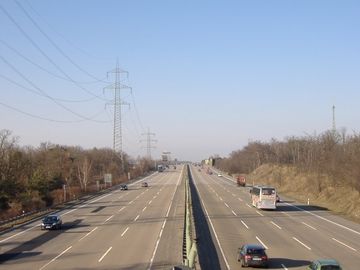
In most cases the motorway is a dual carriageway which means that the traffic for both directions is separated by a central barrier or strip of land.
How to map

|
To map a simple motorway you can just draw a line for it. Select all ways which belong to the motorway and tag them with highway=motorway. Use oneway=yes when it is not possible to drive in both directions on the motorway. Make sure the way points in the same direction as the oneway goes.
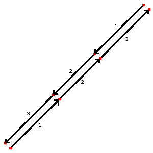
In the case of a dual carriageway you should draw one line for each direction and tag each direction on their own. Be sure to set the nodes for the each direction on the same high, this gives a much better result when the map will be rendered as well as indicates directly that both ways belong together. To attach more information for the motorway you should add further keys. |
Special situations
In the case you do not have a normal motorway you should take a look on these sites:
- highway=motorway_link - The link roads (sliproads / ramps) leading to and from a motorway.
- highway=motorway_junction - Indicates a junction (UK) or exit (US) ref should be set to the exit number or junction identifier.
- bridge=yes - If the motorway goes over a street or waterway.
- tunnel=yes - If the motorway goes below a street or waterway.
International equivalence
| Country | Description | more |
|---|---|---|
| Australia | Motorways, freeways, and freeway-like roads. Divided roads with 2 or 3 lanes in each direction, limited access via interchanges, no traffic lights. Generally 100 or 110 km/h speed limit. For example: Hume Freeway. |
Australian Roads Tagging |
| Belarus | автомагистраль (avtomagistral') | |
| Belgium | nl:autosnelweg fr:autoroute d:autobahn maxspeed=120km/u | |
| France | autoroute (A) | Fr:Map Features |
| Italia | Autostrada, compresi i raccordi autostradali come le tangenziali di Milano e il Grande Raccordo Anulare di Roma. | It:Italian Roads Tagging |
| Germany | Autobahn | |
| Hungary | Autópálya | |
| Korea | Divided, grade-separated highway with 2 or more lanes in each direction. This includes all toll roads designated by a red and blue shield. |
|
| Netherlands | Autosnelweg | Kaart eigenschappen |
| Norway | Stamvei: Motorvei kl A og kl B <br\ > File:No sign-MotorwayStart Duel-502.png File:No sign-MotorwayStart Singel-503.png | |
| Switzerland | Autobahn / autoroute | |
| UK | motorway | |
| US | Divided, grade-separated highway with 2 or more lanes in each direction. Access by ramps only. This includes all Interstate Highways and some US highways. |
Examples
| Picture/Description | Tags | Mapnik | Osmarender |
|---|---|---|---|
|
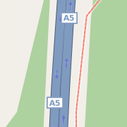
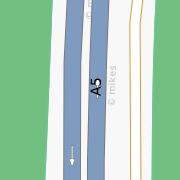
highway=motorway highway=motorway lanes=4 oneway=yes ref=E451 nat_ref=A5
|

|

|
