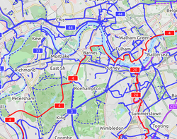
OpenCycleMap
|
OpenCycleMap Cycle Map | |
|---|---|

| |
| Author: | Andy Allan |
| Slippy map: | www |
| Tiles license: | CC-BY-SA 2.0 [1][2] using True Marble imagery (CC BY 3.0 US) |
| Style license: | closed source |
OpenCycleMap is a OpenStreetMap rendering layer like the standard tile layer, but primarily aimed at showing information useful to cyclists. The website www
The map rendering is still being improved, and is updated on average about every two weeks.
It shows National Cycle Network cycle routes, other regional and local routes, and other cycling-specific features, such as:
- dedicated cycle tracks and lanes
- bicycle parking
- contours and hill colouring
- bike shops, toilets, drinking fountains, even pubs!
- proposed bike routes (or numbering protocols), contrasted with the Lonvia map, below, which does not show proposed routes, but actual routes only
- contraflow using oneway:bicycle=*. cycleway:left=* and cycleway:right=* also rendered
Key to the map
TBD: a table with tag / screenshot
See www
Update cycle
The database (as of May 2010) is updated using diff updates, and on average is updated about every two weeks.
While the database could be updated more frequently than that (it has run hourly, in the past), there is always a huge backlog of tiles that need refreshing. Refreshing the tiles takes a few days. The system is self-correcting in that the more popular the tile, the sooner it gets refreshed. But lower zoom levels (5 to 9) may be kept frozen for longer periods.
Contact info / Reporting problems
Bugs and requests are taken via email to support![]() thunderforest (dot) com. Old tickets are available from the OpenStreetMap Trac system at https://trac.openstreetmap.org/query?component=opencyclemap
thunderforest (dot) com. Old tickets are available from the OpenStreetMap Trac system at https://trac.openstreetmap.org/query?component=opencyclemap
When reporting, please verify that it's really a rendering issue first: use the data layer and compare with other background layers.
For general questions or anything else please email Andy Allan using the address on www
Presentation
Andy spoke at State Of The Map 2008 regarding the cycle map, and a video and slides are available from that page.
See also
- CyclOSM
- Key:cycleway
- Bicycle
- Mountainbike
- United Kingdom National Cycle Network
- Slippy map tilenames
- List of OSM-based services
External links
- www
.opencyclemap .org - www
.gravitystorm .co .uk /shine /cycle-info / - www
.gravitystorm .co .uk /shine /cycle-map-help - Waymarked Trails: Cycling by Sarah Hoffman is an overlay which shows marked cycle routes around the world. Updated minutely, it renders actual routes without the state=proposed tag. Therefore, no proposed routes (or proposed numbering protocols) are displayed.
| ||||||||||||||||||||||||||


