File:Hjerting josm bing.gif
Jump to navigation
Jump to search


No higher resolution available.
Hjerting_josm_bing.gif (620 × 600 pixels, file size: 1.16 MB, MIME type: image/gif, looped, 26 frames, 11 s)
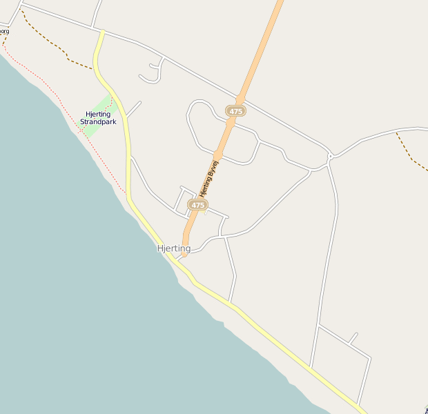
Just two hours of work in JOSM with the new Bing layer in a location (Hjerting, Esbjerg, Denmark) with low coverage. All street names have been added as well, from the updated KMS dataset.
Screenshots were taken about every five minutes and compiled to animated gif.
Full changeset: http://www.openstreetmap.org/browse/changeset/6510990
This is a Featured image, which means that it has been identified as one of the best examples of OpenStreetMap mapping, or that it provides a useful illustration of the OpenStreetMap project. If you know another image of similar quality, you can nominate it on Featured image proposals.
Front-page image for week 49 of 2010 (6–12 Dec.).
- Image descriptions
- Deutsch : Animation eines zweistündigen Auswertens von Bing-Luftbildern mit Ortskenntnis und JOSM. Die Straßennamen wurden von addr:-Punkten übernommen.
- English : Animation of 2 hours' tracing of Bing imagery with JOSM. (Street names added from addr: nodes)
- français : Résultat de deux heures de traçage à partir des images satellites Bing avec JOSM.
- italiano : Animazione di 2 ore di mappatura delle ortofoto di Bing tramite JOSM. (I nomi delle strade sono stati ottenuti dai nodi addr:)
- lietuvių : Vizualizuotas dviejų valandų žymėjimas pagal Bing nuotraukas naudojantis JOSM. (Gatvių pavadinimai paimti iš addr: taškų)
- polski : Dwie godziny rysowania z podkładem zdjęć Bing w JOSM pokazane jako animacja. Nazwy ulic zostały uzupełnione na podstawie węzłów addr:.
- русский : Визуализация двухчасовой обрисовки спутниковых снимков Bing в JOSM. Названия улиц добавлены из точек в схеме Karlsruhe.
Licensing
![]()
![]()
![]()
This screenshot contains OpenStreetMap Carto rendering.
The OpenStreetMap Carto map style is made available under the Creative Commons CC-0 1.0 Universal Public Domain Dedication.
- Attribution to the map data:
![]()
Contains map data © OpenStreetMap contributors, made available under the terms of the Creative Commons Attribution-ShareAlike 2.0 (CC-BY-SA-2.0).
File history
Click on a date/time to view the file as it appeared at that time.
| Date/Time | Thumbnail | Dimensions | User | Comment | |
|---|---|---|---|---|---|
| current | 07:51, 2 December 2010 | | 620 × 600 (1.16 MB) | Findvej (talk | contribs) | Two hours of work in JOSM with the new Bing layer. Screenshots were taken about every five minutes and compiled to animated gif. Full changeset: http://www.openstreetmap.org/browse/changeset/6510990 |
You cannot overwrite this file.