File:Malawi Red Cross hand.jpg
Jump to navigation
Jump to search


Size of this preview: 800 × 533 pixels. Other resolutions: 320 × 213 pixels | 640 × 427 pixels | 1,024 × 683 pixels | 1,280 × 853 pixels | 1,800 × 1,200 pixels.
Original file (1,800 × 1,200 pixels, file size: 267 KB, MIME type: image/jpeg)
Summary
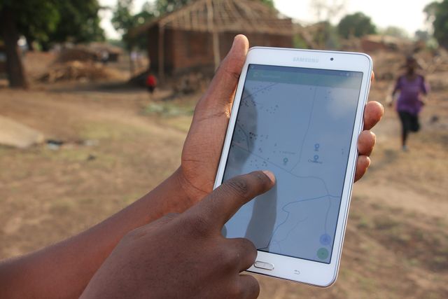
Missing Maps data being used in a flood preparedness mission in Malawi, by the Malawi Red Cross Society and the Netherlands Red Cross. Information on building quality and materials is added to OpenStreetMap to facilitate an efficient aid response.
The picture was taken by the media officer of the Netherlands Red Cross, Belinda van der Gaag.
This is a Featured image, which means that it has been identified as one of the best examples of OpenStreetMap mapping, or that it provides a useful illustration of the OpenStreetMap project. If you know another image of similar quality, you can nominate it on Featured image proposals.
Front-page image for week 49 of 2017 (4–10 Dec.).
- Image descriptions
- English : Missing Maps data being used in a flood preparedness mission in Malawi, by the Malawi Red Cross Society and the Netherlands Red Cross. Information (building=*) on building quality and materials is added to OpenStreetMap to facilitate an efficient future aid response.
- français : Les données Missing Maps sont utilisées dans une mission de préparation aux inondations au Malawi, par la Croix Rouge du Malawi et la Croix Rouge des Pays-Bas. Des informations (building=*) sur la qualité et les matériaux des bâtiments sont ajoutées à OpenStreetMap pour faciliter une future réponse d’assistance efficace.
- italiano : I dati di Missing Maps vengono usati in una missione di prevenzione e risposta delle inondazioni in Malawi, dalla Croce Rossa del Malawi e dei Paesi Bassi. Informazioni sulla qualità degli edifici (building=*) e sui materiali sono aggiunte a OpenStreetMap per facilitare una futura risposta degli aiuti.
- 中文(简体) : 在马拉威红十字会和荷兰红十字会的活动上,Missing Maps 资料被用在马拉威水灾灾前准备的任务。关于建筑品质和材料的 (building=*) 资讯被加到开放街图上面,以协助未来有效的救灾援助行动。
- 中文(繁體) : 在馬拉威紅十字會和荷蘭紅十字會的活動上,Missing Maps 資料被用在馬拉威水災災前準備的任務。關於建築品質和材料的 (building=*) 資訊被加到開放街圖上面,以協助未來有效的救災援助行動。
Licensing
![]()
![]()
![]()
This work is licensed under the Creative Commons Attribution-ShareAlike 3.0 License.
Attribution: Belinda van der Gaag
Attribution: Belinda van der Gaag
File history
Click on a date/time to view the file as it appeared at that time.
| Date/Time | Thumbnail | Dimensions | User | Comment | |
|---|---|---|---|---|---|
| current | 16:03, 20 November 2017 | | 1,800 × 1,200 (267 KB) | Harry Wood (talk | contribs) | Missing Maps data being used in a flood preparedness mission in Malawi |
You cannot overwrite this file.
File usage
The following 13 pages use this file:
- Featured images/Oct-Dec 2017
- List of featured images/2017
- Pt:Featured images/Oct-Dec 2017
- Uk:Featured images/Oct-Dec 2017
- Zh-hans:Featured images/Oct-Dec 2017
- Zh-hant:Featured images/Oct-Dec 2017
- Template:Iotw image/2017-49
- DE:Featured images/Oct-Dec 2017
- FR:Featured images/Oct-Dec 2017
- ES:Imágenes destacadas/Oct-Dic 2017
- IT:Featured images/Oct-Dec 2017
- RU:Featured images/Oct-Dec 2017
- JA:Featured images/Oct-Dec 2017