JA:Tag:aeroway=helipad
Jump to navigation
Jump to search
 |
| 説明 |
|---|
| ヘリコプター用に設計された着陸用区域または台 |
| OSM Cartoでのレンダリング |
| OSM Cartoでのレンダリング |

|
| グループ: 空路 |
| 適用できる要素 |
| よく併用されるタグ |
| 状態:承認 |
| ツール |
aeroway=helipadタグはヘリパッド、つまりヘリコプターが着陸できるように設計された区域または台のために使われます。
上空から識別できるよう、丸で囲まれた「H」の文字が書かれています。(「R」の文字は緊急救助用スペースであり、ヘリパッドではありません。比較的新しい病院の屋上ヘリパッドは、赤地に白い十字のマークになっています。) 空港またはヘリポートの一部として、あるいは病院や、大きなホテル、会社や政府の本部などにあることもあります。
このタグはヘリパッド用に建設されたか、ヘリパッドとして日常利用されている設備にだけ用いるべきです。緊急離着陸場については「区別」の節を参照してください。
マップの仕方
ヘリパッドの中心にノードを置き、aeroway=helipadのタグを付けます。あるいは、ヘリパッドの輪郭を囲い、同じタグを付けます。
例
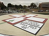
United States:
aeroway=helipad
maxweight=30000 lbs
maxrotordiameter=46'
United States:
aeroway=helipad
maxweight=15000 lbs


.jpg)
区別
- aeroway=heliport - ヘリコプター専用の空港
- emergency=landing_site - 緊急時にヘリコプターが着陸できるよう予め定められた平坦な区域
日本
日本国内でヘリコプターの離着陸ができる場所は、空港・飛行場以外に、公共用ヘリポート(12か所、access=yes)、非公共用ヘリポート(90か所、access=private)、飛行場外離着陸場(1万か所以上、access=license)、屋上緊急離着陸場(access=no)に分類されています。
外部リンク
- U.S. FAA specifications for helipads and heliports
- 国土交通省の空港一覧 - 公共用ヘリポートと非公共用ヘリポートの一覧が含まれる
| ||||||||||||||||||||||||||||||||||||||||||||||