Tag:aeroway=helipad
 |
| Description |
|---|
| A landing area or platform designed for helicopters |
| Rendering in OSM Carto |
| Rendering in OSM Carto |

|
| Group: aeroways |
| Used on these elements |
| Useful combination |
| Status: approved |
| Tools for this tag |
|
The tag aeroway=helipad is used for a ![]() helipad - a landing area or platform designed for helicopters to land.
helipad - a landing area or platform designed for helicopters to land.
Often a large circle or cross with a large H painted on it visible from the air. It might be part of an aerodrome or heliport but can also be found in grounds of hospitals, on top of major hotel buildings, business/political headquarters and similar locations.
Materials used for helipads primarily consist of concrete, aluminum, and steel. Ground based helipads are predominantly concrete. Elevated and rooftop helipads use aluminum and steel.
Lighting systems are secured to the top of the helipad for visibility purposes. These consist of perimeter lights, floodlights, and status & repeater lights. Additional equipment include crash rescue supplies and a fire suppression system.
The tag should only be used for infrastructure that is purpose-built and/or regularly used for this purpose. See the differentiation section for emergency landing sites.
How to map
Add a node at the centre of the helipad and add the aeroway=helipad tag, or create an outline of the helipad with the same tag.
Examples
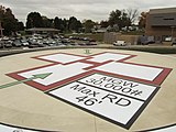
United States:
aeroway=helipad
maxweight=30000 lbs
maxrotordiameter=46'
United States:
aeroway=helipad
maxweight=15000 lbs


.jpg)
Differentiation
- aeroway=heliport – a special aerodrome built for helicopters
- emergency=landing_site – for a predefined area with a flat surface (e.g. field, river bank) where a helicopter can land in an emergency situation.
External link
| ||||||||||||||||||||||||||||||||||||||||||||||