Tag:aerialway=drag_lift
 |
| Description |
|---|
| An overhead tow-line for skiers and riders. |
| Rendering in OSM Carto |

|
| Group: aerialways |
| Used on these elements |
| Useful combination |
|
| Status: de facto |
| Tools for this tag |
|
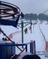
A drag lift. An overhead tow-line, usually around 4 meters above skiers and riders. It is known as a T-bar lift, with a T shaped bit which two skiers share by resting their bottom on the bar. It is known as a button or platter lift where the passengers place a circular disk in between their legs. More difficult and uncomfortable for snowboarders. drag_lift would also cover more simple looped rope drag lifts, or loops of wire with handles to grab.
![]()
This is just one classification among several cable/wire based lifts/transportation types listed under Key:aerialway. See also WikiProject Piste Maps
How to map
Draw a way along the route of the cable, and set this aerialway=drag_lift tag on this way.
This automatically implies oneway=yes (drawn upward).
Tags used in combination
- name=*
- ref=*
- aerialway:capacity=*
- aerialway:duration=*
Additional features
Position nodes ![]() at either end of the cable. These nodes might be tagged with aerialway=station
at either end of the cable. These nodes might be tagged with aerialway=station
If you know the position you can also map support pylons by positioning nodes ![]() in the middle of the way, with the tag aerialway=pylon.
in the middle of the way, with the tag aerialway=pylon.
Similar tags
Photos
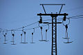
bottom of a T bar lift
Empty T bars

j-bar

platter


| ||||||||||||||||||||||||||||||||||||||||||||||