Tag:aeroway=hangar
 |
| Description |
|---|
| A large airport building with extensive floor areas for housing aircraft or spacecraft |
| Group: aeroways |
| Used on these elements |
| Useful combination |
| Status: de facto |
| Tools for this tag |
|
A ![]() hangar is a building at an airport, aerodrome, or airfield used for sheltering, storing or repairing aircraft.
hangar is a building at an airport, aerodrome, or airfield used for sheltering, storing or repairing aircraft.
Typical modern hangars are constructed from concrete and steel, and are rectangular in shape when viewed from above. However, the shape, size, form, and materials used can vary greatly. These include tent-like hangars found on temporary military airfields, concrete bunkers on permanent airfields, underground hangars, small wooden barns and large airship hangars.
How to map
Trace the outline of the building and tag it with aeroway=hangar. Additional tags like building=yes or building=hangar will help applications that don't handle aeroway=hangar properly. Hangars are normally rectangular, so JOSM's orthogonalize tool (hotkey 'Q') might be useful to make it all nice and straight.
Photos
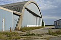
A disused hangar.
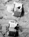
Aerial view of bomb-damaged concrete hangars at the Ahmed Al Jaber Airfield in Iraq.
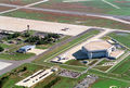
An aerial view of the Air Force One hangar at Joint Base Andrews Naval Air Facility.

The hangar used by the Wright Brothers. Essentially just a shed.


| ||||||||||||||||||||||||||||||||||||||||||||||