JA:Relation:route
 |
| 説明 |
|---|
| さまざまな種類のルートを記述するために使用します。 |
| グループ: ルート |
| メンバー |
|
| よく併用されるタグ |
| 関連項目 |
| 状態:事実上の標準 |
| ツール |
ルートは反復的、定期的な通行や旅行の路線で、しばしば事前に決められ、公開されているものです。北大西洋航路上の船舶、番号付きの道路上の自動車、路線バス、あるいは国道上のサイクリストなどといった、様々な人々や乗り物によって繰り返し利用されるルートから成っています。
ルート(またはその変形)はルートマスターリレーションに所属させることができます。ルートマスターには、すべての方向や変形のルートと、ルートに関する情報を含めることができます。それによって、OSMが双方向の交通における2つのルート(行きと帰り)を識別することができます。
道路は複数の番号を持つことがあることに注意してください。多くの主要ヨーロッパ "E" ルート はルートを番号付きの国道と共有しています(時には全く同じものであることもあります)。
| JA:サイクリングルート のルールで記述したルートの表示例 |
 ハイキングルートの表示例 |

タグ
| キー | 使用 | 値 | 説明 |
|---|---|---|---|
| type | ! 必須 | route | このリレーションがルートであることを表します |
| route | ! 必須 | road / inline_skates / evacuation / detour / bicycle / mtb (マウンテンバイク) / foot / hiking / running / bus / trolleybus / waterway / ferry / canoe / train / railway / tracks / tram / funicular / horse / ski / snowmobile / piste | 道路(例、高速道路A7を構成するウェイ)、サイクリングルート、ハイキングルートその他あらゆるルートの種類です。(#使用中のルートリレーション参照) |
| name | ‽ 重要 | 名前 | この名で呼ばれている、ルートの名前(例:「青梅街道」、「中山道」、など) |
| ref | ‽ 重要 | 参照記号 | 知られているルートの記号(例:「1」、「K1」、「藤72」、など) |
| network | ‽ 重要 | ncn / rcn / lcn / nwn / rwn / … | ルートが所属するネットワーク(例:「首都高速道路」、「富山市内線」(路面電車)、など) |
| direction | ? 任意 | north / south / east / west | カナダ、ニュージーランド、アメリカ合衆国において、スーパー・リレーションに属する別々のリレーションとしてマッピングされているルートの公称方位。 |
| operator | ? 任意 | 運営者名 | ルートを運営する機関や会社(例:「中日本高速道路」、「群馬県」、「東京都交通局」(バス)、など) |
| state | ? 任意 | proposed / alternate / temporary / connection | 時としてルートは不変ではなく (すなわち、路線転換), あるいは提案された(proposed)状態にあるかもしれません(たとえば、UK NCN ルートは時々公式ルートではなく、何らかの交渉や開発が保留されている場合があります)。接続(connection)は、二つの異なるルートをリンクしたり、例えばビレッジセンターにリンクするルートに使われます。 |
| symbol | ? 任意 | シンボルの記述 | ルート上のウェイであることを記すために使われるシンボル。例)ドイツのフランケン地方にある"Frankenweg" は「白地に赤十字」で示されます。 |
| colour | ? 任意 | 色名またはhex triplet | hex triplet形式で色コードを記述します。とくに公共交通ルートで有用です。例:ティールブルーは「#008080」 |
| description | ? 任意 | 短い説明 | このルートに関する特記事項 |
| distance | ? 任意 | 距離 | このルート全体の道のり(わかる場合)。利用者の便宜や(たとえば完全性の)自動評価のための情報です。既定の単位は km で、小数点にはドットを使います。単位を指定する場合には、数字との間はスペースで区切り、単位のページで説明されている通りにしてください。 |
| ascent | ? 任意 | 総上昇量 | ルート全体を通した延べ高度上昇量です(規定の単位はメートルで、他の単位を使う場合は明記します)。ルートの始点と終点が別の高度にある場合は、総下降量(descent)も使用します。 |
| descent | ? 任意 | 総下降量 | ルート全体を通した延べ高度下降量です(規定の単位はメートルで、他の単位を使う場合は明記します)。総上昇量と異なる場合のみ使用します(ルートの始点と終点で高度が違う場合)。 |
| roundtrip | ? 任意 | yes / no | ルートの始点と終点が同じ場所かどうか。つまりルートを1回通過した後に始点に戻ってくるかどうか。 |
| interval | ? 任意 | The time between departures of any given stop on a public transport route. | This tag should only be used on public transport routes. Use HH:MM:SS, H:MM:SS, HH:MM, H:MM, MM, or M format. Example: interval=00:12:30 can be added to a subway route that runs trains every 12.5 minutes. |
| duration | ? 任意 | The duration time between the start and end, e.g. first and the last stop on a public transport route. | This tag is used on public transport routes, hiking routes and others. Use HH:MM:SS, H:MM:SS, HH:MM, H:MM, MM, or M format. Example: duration=00:42 can be added to a subway route that take 42 minutes from start to end. |
| tourism | ? 任意 | yes | If the route is of specific interest to tourists. |
メンバー
ここではすべてのロールについて概要を記載しています。特定の種類にのみ使用できるものもあるため、あるリレーションにこれら全てを追加することは合理的ではありません(たとえばforwardは PTv2のルートでは無効です)。 |
| 要素 | ロール | 繰り返し | 議論 |
|---|---|---|---|
| ! 1+ | ルートを構成するウェイ。 Currently the empty role should be used instead of the | ||
| ? 0+ | ルートの一部または全部が一方向だけにたどれる場合、ルートを構成する一部または全部のウェイに「ロール」として示すことができます。 これらのロールは公共交通のルートには使用しないで下さい。 (ロールは空にして下さい) | ||
| ? 0+ | カナダ、ニュージーランド、アメリカ合衆国において、ルートが1つの双方向のリレーションとしてマッピングされている場合に、ロールとして4方位が指定されると、ウェイがルートのどの公称方位を担っているかを示します。 | ||
| ? 0+ | このロールは公共交通のルートにのみ使用して下さい。
自由乗降区間がある場合にその区間の道路に使用します。アジア諸国によくあります。 | ||
| ? 0+ | 一部の道路 このロールは公共交通のルートでは今後使用すべきではありません。(代わりにウェイをルートリレーションに2回追加してください) | ||
| ? 0+ | ルートに出入りするための連絡路(highway=*_link)。highway=motorway_linkを参照してください。注: これはよく言っても非常に疑わしく、おそらく常に望ましくないものです。多くの、おそらく全ての場合に、ルートに出入りする連絡路を追加することは間違っています。 | ||
| ? 0+ | このロールは公共交通のルートにのみ使用して下さい。
ルート上の道路 | ||
| ? 0+ | このロールは公共交通のルートにのみ使用して下さい。
ルートに沿ったバスや列車のプラットホームです。リレーション内でのメンバーの順番は、時刻表の停車順と同じにしてください。
かつてPTv1では、マッパーが停車場の不足や置き間違いを見つけられるように | ||
| ? 0+ | ルートを表す標識です。 information=guidepost を参照してください。 | ||
| ? 0+ | (signed) kilometre, mile, leg, etc. | ||
| ? 0+ | Information board, information stand about the route (and only the route). | ||
| ? 0+ | Used in route=fitness_trail (see fitness_station ), in route=worship (see stations_of_the_cross and wayside_shrine ) and for educational=yes (for "marked stations or stops next to points of natural, technological or cultural interest"). | ||
| * | Taginfo でよく使われている値を確認できます。 |
Note: to ensure a route is properly connected when using a two alternative directions (alternative route A1 and A2, using the ![]() forward and
forward and ![]() backward roles), make sure the element before the branch connects to the first element in A1 and the element after the branch connects to the last element of A2. Also note that the
backward roles), make sure the element before the branch connects to the first element in A1 and the element after the branch connects to the last element of A2. Also note that the ![]() forward and
forward and ![]() backward roles refer to the directionality of the ways in A1 which need to be going in the same direction; if not all ways in A1 run in the same direction it may be necessary to use both
backward roles refer to the directionality of the ways in A1 which need to be going in the same direction; if not all ways in A1 run in the same direction it may be necessary to use both ![]() forward and
forward and ![]() backward for the same alternate route A1.
backward for the same alternate route A1.
ルートの種類 (route)
The list below is alphabetical and is derived from Map Features#Route, which contains the most commonly accepted values. For a list that is ordered by general route type and that also contains some values that are less-widely accepted, please see Key:route.
| キー | 値 | 要素 | 説明 | レンダリング | 写真 |
|---|---|---|---|---|---|
| route | bicycle | サイクリングルートでどのようにタグ付けするか説明されています。 |  | ||
| route | bus | 路線バスの系統です。バスも参照してください。 |  | ||
| route | canoe | 水路を通るカヌーのルートです。 |  | ||
| route | detour | 恒常的な迂回ルート。 例えば、ドイツの Bedarfsumleitung やオランダの uitwijkroute など。 | ,_StVO_1970.svg)
| ||
| route | ferry | ターミナルからターミナルまでを繋ぐフェリー(連絡船)の航路。ズームレベル12の各タイルに少なくとも1点作るようにしてください。大体2,3キロメートルごとに1点くらいです。こうするとオフラインエディターや Tiles@home が、 bbox リクエストでこのルートを拾えるようになります。 |  |
 | |
| route | foot | ウォーキングルート - フィットネス、機材、気象条件に関する制限なしに歩くことができるルートに使用されます。 |  | ||
| route | hiking | ハイキングでどのようにタグ付けするか説明されています。 |  | ||
| route | horse | 乗馬ルートです |  | ||
| route | inline_skates | この件についての詳しい情報は Inline にあります。 | |||
| route | light_rail | ライトレールの運行系統です。 |  | ||
| route | mtb | マウンテンバイクでどのようにタグ付けするか説明されています。 |  | ||
| route | piste | ウィンタースポーツ会場内の雪上ルート(スノーシューやクロスカントリースキーのコース)。 |  | ||
| route | railway | 一連の鉄道路線のウェイで、通常は名前が付いているものです(例: 東海道本線、山陽本線、英仏海峡トンネル)。詳細は、鉄道を参照してください。 |  | ||
| route | road | いろいろな道路ルートの指定や、長い道路に使います。 |  | ||
| route | running | ランニング(ジョギング)のルートです。 |  | ||
| route | ski | スキーのコースに使用します(例: XCスキールート) |  | ||
| route | subway | 地下鉄の系統です。 |  | ||
| route | train | 鉄道の運行系統です(例: 京浜東北線、JR神戸線、ロンドンパリユーロスター)。鉄道を参照してください。 |  | ||
| route | tracks | 鉄道インフラとしての線路です。 | | ||
| route | tram | 路面電車の系統です。路面電車でどのようにタグ付けするか説明されています。 |  | ||
| route | trolleybus | トロリーバスの系統です。 |  | ||
| route | ユーザー定義 | Taginfo でよく使われている値を確認できます。 |
This table is a wiki template with a default description in English. Editable here. 日本語訳の編集はこちら。
公共交通ルート
- 主な記事:JA:公共交通機関
すべての公共交通機関のリレーションは次のキーの組み合わせで構成されます。
| キー | 使用 | 値 | コメント |
|---|---|---|---|
| type | ! 必須 | route route_master |
|
| route route_master |
! 必須 | bus trolleybus minibus share_taxi train light_rail subway tram ferry |
公共交通機関はOpenStreetMapのかなり複雑で論争の多いトピックであるため、最新の記述に保ちwiki中で記述が矛盾しないよう、この節では最低限の記述に留めています。詳しい情報はJA:公共交通機関を参照してください。
道路ルート
各国の国道のリストですが、一部のみにしています。英語版のページも参照して下さい。
| route | network | 説明 |
|---|---|---|
| road | e-road | European E-road network - 欧州自動車道路 |
| road | US:I | Interstate Highways Relations - USAの州間高速道路 |
| road | US:US | United States Numbered Highway Relations - USAの国道 |
| road | BAB | ドイツのアウトバーン |
| road | ca_transcanada | Canadian トランスカナダハイウェイ |
| road | ru:national | Автодороги России - ロシアの国道 |
| road | BR | ブラジルの連邦道路 |
| road | JP:national | 日本の国道 |
| road | JP:prefectural | 日本の都道府県道 |
迂回路
| route | 説明 |
|---|---|
| detour | 高速道路での渋滞を回避する恒常的な迂回ルート。 例えば、ドイツの Bedarfsumleitung やオランダの uitwijkroute uitwijkroute など。 |
サイクルルート (マウンテンバイクも含む)
- 主な記事:Cycle routes
| Key | Presence | Value | Description |
|---|---|---|---|
| route | ! 必須 | bicycle / mtb | "bicycle/mtb"とするのではなく、"bicycle" か "mtb" のどちらかを使ってください。 |
| network | route=bicycle には ! 必須
for route=mtb には ? 任意 |
Specify the network as a international route, national route, a regional route or a local route, as per the normal tagging of cycle routes | |
| icn | International cycling network: long distance routes used for cycling routes that cross continents. | ||
| ncn | National cycling network: long distance routes used for cycling routes that cross countries. | ||
| rcn |
Regional cycling network: used for cycling routes that cross regions. | ||
| lcn | Local cycling network: used for small local cycling routes. Could be touristic loops or routes crossing a city. | ||
| ref | ? 任意 | Official reference | The reference number/ID found on signposts etc. |
| state | ? 任意 | proposed | Routes are sometimes not official routes, pending some negotiation or development. Maps may choose to render these routes differently; e.g., as dotted lines. |
Some examples in use:
- Part of UK NCN Route 4
 Part of UK NCN Route 4
 - Part of London Route 5 Part of London Route 5
歩行ルート(ハイキング、巡礼も含む)
- 主な記事:JA:徒歩ルート
ハイキングのルートはルートリレーションで広範にマップされており、 Waymarkedtrails map ではここでの提案と osmc:symbol=* の記述に従って描画されます。
ハイキングのルートはHiking and Trail riding map (ドイツ語)内のドイツの選択されたエリアに対して描画されます。レンダリングに必要なタグは以下のとおりです:
| タグ | 使用 | 値 | 解説 |
|---|---|---|---|
| type | ! 必須 | route | |
| route | ! 必須 | hiking | Typically longer or more strenuous routes, usually on unpaved paths. |
| foot | Typically easier routes, usually on paved surfaces. | ||
| network | ! 必須 | iwn | International walking network: long distance paths used for walking routes that cross several countries, for example the Camino de Santiago |
| nwn | National walking network: long distance paths used for walking routes that cross countries | ||
| rwn |
Regional walking network: used for walking routes that cross regions. | ||
| lwn | Local walking network: used for small local walking routes. Could be touristic loops or routes crossing a city | ||
| name | ‽ 重要 | このルートの識別に適した意味のあるルート名。 | |
| symbol | ? 任意 | ルートマーカーシンボルの文章での説明。 | |
| osmc:symbol | ? 任意 | ルートマーカーシンボルのコード化された説明。 | |
| pilgrimage | ? 任意 | yes / no | このルートが巡礼に使われるかどうか。これによって新たなルートタイプroute=pilgrimageを作るのではなくhiking/footルートを使用することができます。 |
インラインスケートルート
- 主な記事:Inline skating
インラインスケート(ローラースケート)のルートは、主にスイス(EN:Switzerland/InlineNetwork)とオランダにてマッピングされてきました。Lonvias Skating mapにおいて、そのようなルートを表示します。
| キー | 出現条件 | 値 | コメント |
|---|---|---|---|
| route | ! 必須 | inline_skates | インラインスケートのルートであることを表します。 |
| network | ! 必須 | international / national / regional / local | ネットワーク(道路網)が国際的、国内、地域内、または地元のルートのどれであるかを特定します。 |
| ref | ? 任意 | Reference | 現実に番号が使用されている場合、参照番号が最良の機能を発揮します。"national 4"(国道4号)に対しては"4"を使うべきです。networkタグを用いて正確に道路網の種別を区別できていれば、まさにこの"ref"タグを使うべきです。 |
| state | ? 任意 | proposed | 交渉や開発事業が係争中・未決定の間は、ルートが非公式なものであることがあります。マップレンダーはこれらを点線で表示します。 |
実例:
- Part of Swiss National Route 3 Part of Swiss National Route 3
- Route 72 around the Greifensee Route 72 around the Greifensee
- Skating network in Midden-Delfland, Netherlands Skating network in Midden-Delfland, Netherlands
その他のルート種別
以下の表は今現在使われているルートタグの一覧です。
| route | 説明 |
|---|---|
| evacuation | Emergency evacuation routes |
| fitness_trail | フィットネス・トレイル(Wiki_en:Fitness_trail )=障害物や運動設備を伴った運動コース |
| horse | riding を参照のこと。 |
| inline_skates | インラインスケートのルートで、名称や付番がなされているもの、 またはinline skatingのルートとして記されているもの。 |
| running | エクササイズに使用される、著名なランニングルート。 しばしば2~20kmほどの長さがある。 |
| snowmobile | スノーモービル用ルート。2地点間を結ぶもの、または誰かが運営するルートの集合体。 |
| taxi | route=share_taxi を参照のこと。 |
| trolleybus | JA:バス を参照のこと。 |
| cycling | サイクリングイベントのうち、ツール・ド・フランスのステージのようなものに用いられる。レクリエーション・娯楽用のルートについては bicycle を参照。 |
| historic | 歴史的なルート。 郵便配達や古代の交通路として用いられてきたhorse-pack trailsなど(訳者注:日本の東海道などの旧街道筋が該当?)。しばしばいくつかの区間が失われている。適切な historic=*の値を含めてください。 |
| motorcycle | Used for motorcycling events (motorcycle rally, guided tours) |
| transhumance | For long distance livestock paths |
| waterway | A route via navigable waterways, suitable for commercial shipping or recreational boating |
| worship | A route along which fixed points of worship are placed, e.g. a via Crucis. |
マッピング方法
複数ルートで同じパスを共有
特に自転車ルートにおいては、遠く離れた目的地への複数のルートが同じウェイ(道路)を経由しています。多様な組織により運営される多くの自転車ルート網、それらルート網が重なることは異常なことではありません。例えばEuroVeloルート網においては、多くの国で既存のインフラ(道路網)を利用しています。 この場合は2つのマッピング方法があり、もし複数ルート内のとある区間が同じウェイを共有していた場合、
- 所属しているルートのリレーションの全てに、ウェイを追加する。
- ルートを区間ごとのリレーションに分割し、上位の「スーパー・リレーション」(ウェイは含まないが、他のリレーションを含むもの)を作成する。そして共有されている区間を全てのスーパー・リレーションに追加する。
これらの方法はどちらも利点と欠点があります。
ウェイを複数のルートリレーションに追加する方法
- 多くのルートが1つのウェイを共有する場合、ルートの新規区間をマッピングしようとすると作業数が多くなります。なぜなら全てのリレーションにそのウェイを追加していかなければならないからです。
- 人はおそらくそのウェイが他のルートに使用されていることは見ておらず、全てのリレーションにウェイに関する変更や変化の適用を忘れるでしょう。するとデータが不一致を起こしてしまいます。
- おそらく比較的簡単な方法です。なぜなら、リレーションを区間分けし、どの区間を編集すべきか見つけることは初心者にとってやや困難だからです。
- リレーションは巨大になり、動作が大変になります(分析ソフトはそのプロセスに時間を要し、地図描写には長いJavaScript CPU timeを必要とします)。
- もしスーパー・リレーションを全く使用しなかった場合、代替(alternative)ルートと脇道(excursion)ルートもリレーションに追加する必要があります。これだと分析ソフトやツールにルートを理解させるのが難しくなります。role=excursionと role=alternativeが提案されていますが、それらは未だにどのウェイがどの脇道ルートに属するのか示していません(if there are multiple ones)。
- 複数オブジェクトをグループ化しまとめることが、リレーションの目的です。2つのprimary road(日本においては主要地方道)がいくつかの区間において同じ通りを共有している時は、同じノードを共有する2つのウェイを作成してはいけません。なので同じウェイを共有する2つのリレーションを作るべきではないことになります。
スーパー・リレーションを作成する方法
- 主な記事:Superrelation
- 現在の(CycleMapのような)地図レンダラーはスーパー・リレーションをサポートしておらず、"ref"(参照番号)と"network"タグが表示されません。現在、それら全てのタグが全ての区間リレーションに追加される必要があり、多くの作業を必要とします(特に、区間が所属するルート全てが違う"ref"を持っている必要があるときなど)。
- リレーションを1経路に保つことは良いマッピング技術だと言われています。なので代替・脇道ルートは他のリレーションに入れる必要があります。よって、ルートを区間分けしない場合でも、しばしばスーパー・リレーションが必要になるのです。
- 地図ツールと分析ソフト(例えばOSM Relation Analyzerの、特にGPX export機能)はスーパー・リレーションをまだサポートしていません。これはルートをまとめて分析することが難しくなります(これは重要で、例えば、地図のどの程度まで既にマッピングされたのか計算することなどです)。
(※注:OSM Route Manager, waymarked trails, JOSM, knooppuntnet monitorはサブ(子)リレーションをサポートしています) - スーパー・リレーションの取扱い方に関して、文章化された協定がありません。一見すると、スーパー・リレーションは単純に見えます――全てのタグを全てのメンバーに引き継ぐだけですから――しかしそうではありません。メンバーリレーションへの引き継ぎのときに、訳の分からない、または文脈・意味が変わってしまっているタグがあります(例:"distance"(距離)や"note"(注釈))。基本となるリレーション中以外のロールでも同様のことがいえます(例:"forward"/"backward"のロール)。
- リレーションが複数のスーパー・リレーションに、またはウェイが複数のリレーションに属するとき、スーパー・リレーションはとても紛らわしくなります。この場合、もはやどのリレーションやウェイが正しいもので、そのタグを適用されるべきなのか決定的ではなくなります。
- 誰かが新しいルートをマッピングした時、ウェイを共有するルートを別のルートに分割する必要があるかもしれません。それらの別ルートを編集する人は、多くのサブリレーションが常に更新し続ける際に混乱するでしょう。
- 現在のエディタは「リレーション分割」(そしてスーパー・リレーションのレンディング)のような、発展的なリレーション編集の特徴を欠いています。1つのルートが何百もの小さな区間リレーションからなる際、非常にややこしくなります。
- OSMの一つのモットーが、「レンダラーの為にマッピングしない」です。もしスーパー・リレーションの作成がもっと自然なマッピング方法だと考えるなら、我々がその方法をとることが、レンダラーとツールにおいて(スーパー・リレーションの)サポートが無いという理由で抑制されるべきではありません。
- スーパー・リレーションはサーバーからデータを要求する際に必ずしも含まれるわけではないことを考慮してください。なので、スーパー・リレーションが含まれていたかどうかによって、データの解釈(レンダリング)は違ってきます。あなたがウェイやリレーションが他のリレーションのメンバーであるかどうか判別できないのと同様、あなたは関連性のあるデータが全て見えているかどうか確信できないでしょう。
- もしとある完結したルートが他のルートの一部である場合、(ドイツの"D6"は"EuroVelo EV6"の一部であるように)スーパー・リレーションを作ることは常識です。もし現在、EV6が他の経路の一部だけを他国で共有しているなら、どのみち区間リレーションを作成する必要があります(他にサブリレーションとウェイの両方を含むリレーションを作成することになります)。その方法か他の方法のどちらかを使用するべきです。
- 人はマッピングしているルートだけを知る必要があります。とある誰かがドイツの"D6"ルートをマッピングしたとき、("EV"の標識が彼の地域に存在しなかったかもしれないので)EuroVeloネットワークのことを知る必要はないのです。なぜなら、スーパー・リレーションによって、ルートの一部は自動的に全ての親リレーションに追加されるからです。これはOSMのコンセプト、「各自が知っている場所や地物をマッピングすることで、完璧な世界地図は発展していくのです」により合致しています。
この時、もし分割された区間が、ルート全長と比較して相対的に大きかったのなら、より区間リレーション作成の練習を積む必要があるでしょう。国内の自転車ルートにおいて、20kmが上限として適切です。短めの区間においては、単独のウェイは所属するリレーションの全てに加えられるでしょう(もちろんこれは経験則で、公式のマッピング方法には存在しません)。OSMにおいては、区間がいくつの個別のウェイで構成されているかということも重要です。区間分けをすることはもしルートが自動車道路(少数の長いウェイを含んでいるよう)からなる場合、あまり実用的ではありません。複数のリレーションがあったとしても多くのウェイを加えざるを得ないような多くの都市や住宅街をしばしば自転車ルートが通り過ぎている一方で、です。
用いるタグ付けを決めるときのもう一つの注意点は、もしルートが同じウェイを使っていた場合、「偶然の一致による」ものだけを調べることです。このようにして、あるルートが変更された場合、他のルートが未だ古いウェイを使用し続けるようであったなら、区間リレーションを用いることは適切ではないでしょう。
サイズ
一般的な方法では、250~300以上のメンバーを含むリレーションを作ることはありません。よく起こることですが、もっと大きなリレーションを作りたいのなら、適切な大きさにしたリレーションをいくつか作り、上記のスーパー・リレーション内で結合させて下さい。 理由は、
- リレーションを編集しやすい状態で維持するため。
- 競合を避けるため。リレーションが巨大になるにつれ、複数のユーザーが同時に1つのリレーションを編集する可能性が高まるためです。
- サーバーの容量を節約するため。
"monster"リレーションのリストが存在します。
バスルートとラウンドアバウト
ラウンドアバウトを経由するバスルートをマッピングするには以下の2つの手法があります。
- ラウンドアバウト全てをルートのリレーションに含める。
- ラウンドアバウトを分割(split)し、バスルートが経由する部分をルートのリレーションに追加する。
どちらの手法が推奨されるべきか、OSMコミュニティの間では総意は得られていません。分割されたラウンドアバウトは mkgmapによって再結合するため、手法1か2の選択はガーミン(GPS)機器に影響を及ぼしません。Mapnikにおいても、メインマップのレンダリングでラウンドアバウトの再結合が行われていないにも関わらず、それは可能です。もし正確なルートが要求され、かつ手法1が使われたとき、ラウンドアバウトに入る・出る位置、または(バスがラウンドアバウト内で停車するなら)バス停の位置から(注:いくつかの事例では、バスは1回以上ラウンドアバウトを全周することがあります)、細部が導き出される必要があるということを、ソフト開発者は頭の片隅に置いておくべきです。
順序問題
多くのルートリレーションでは、メンバーの順序が問題となります。たとえば、順序付けされていないハイキングルートリレーションは、かなり役に立たず、判読できない標高グラフになります。
.png)
また、利用者はルートの経路をたどるにも行ったり来たりで理解が困難になります。
したがって、ルートを編集するユーザーは、ルートがある場合は順序を維持するか、ルートでない場合は順序を変更する必要があります。 JOSMにとって良いヒントは、リレーションエディターのメンバーセクションの最後の列を確認することです。この列に一方向の矢印しかなく、メンバー間に赤い点がない場合、メンバーはきちんと順序付けられます。
一方、順序付けられていないリレーションメンバーは、この列に両方向の矢印を表示し、孤立したメンバー(矢印のないセグメントと2つの赤い点があるセグメント)を示し、連続性が切れている箇所には赤い点が多数表示されます。
一部のエディターは (PTv2-)リレーションを適切に処理できず、ウェイを分割すると順序付けがかわる可能性があることに注意してください(e.g. iD-issues: [1], [2] or[3])。
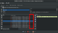
メンバーの順序が正しい
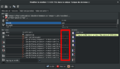
メンバーの順序がばらばら


ステップバイステップガイド
新しいルートの作り方です(既存のルートにウェイを追加する場合とは異なります)。
Potlatch
- ルートが通るところには全てのウェイが存在し、適切にタグ付けされていることを確認してください(例 highway=footway)
- 最初のウェイを選択して右サイドの二番目の、ふたつの区画を鎖でつないだように見えるシンボルをクリックしてください。
- もしこのエリアに既存の正しいリレーションがある場合、ドロップダウンからリレーションを選択してください。選択する既存のリレーションが離れている場合は、検索機能を使ってください。もしくは、新しいリレーションを作成 を選択して追加をクリックします。
- type タグにrouteという値を付けて追加します。
- 必要に応じてタグを追加します。 (+ ボタンを使用)
- OKをクリック。
- リレーションがウェイに追加されます。リレーション詳細の右側に対する、およびXの左に対するグレーのボックスはリレーション内のウェイのロールに対する入力フィールドです、ルートリレーション種別内のロールの詳細は上記Membersセクションを参照。
- 正しいリレーション(今作成したもの)をステップ3で選択しながら、ステップ2-4を繰り返します。
JOSM
- ルートが通るところには全てのウェイが存在し、適切にタグ付けされていることを確認してください(例 highway=footway)。
- リレーションペイン(
Alt+R) が開いていることを確認してください。 - リレーションペインの
Newを選択して新しいリレーションを作成します。 - ポップアップ表示されるダイアログ中に適切なタグを入力してください、少なくとも type=route と、できればname 、そして同様にルート用の名前も。
OKをクリック。- さぁ、ここでリレーションに追加したいウェイを通常の選択 (
S) ツールを使って、一部または全部を選択し、あなたのリレーションがハイライト表示されているリレーションペインで編集をクリックします。リレーション編集ダウアログがポップアップします。 - リレーションダイアログの
Add selectionをクリックして選択したウェイをリレーションに追加します。
relation:route を使ったナビゲーション
既存の relation:route を使ったナビゲーションのできるアプリケーションを追記してください。
- cycle.travel は(type=bicycle および type=road の) route リレーションを、経路選択の重みづけに利用しています。
関連する提案
- Proposed features/via ferrata proposes a relation of type=route, route=ferrata
注釈
タグ付け間違いの可能性
|
The attribute type=route should not be used on node |
支援ツール
- OSM Relation Analyzer (possible to search for relations by name)
- OSM Route Manager
- Hikingbook.pl automatically creates route descriptions and maps, as well as POI directory
- Rel2gpx exporter
| ||||||||||||||||||||||||||||||||||||||||||||||