Ko:Relation:route
| 설명 |
|---|
| 다양한 방법으로 노선을 표현하고자 할 때 사용합니다. |
| 그룹: 노선 |
| 구성원 |
|
|
| 유용한 조합 |
| 같이 보기 |
| 상태:사실상 표준 |
| 이 태그를 위한 도구 |
|
영어 원본의 내용을 이해할 수 있다면 번역 완료에 힘을 모아 주십시오. 번역 방법에 대해서는 위키 번역 방법에 대한 설명을 읽어주시길 바랍니다. 만약 이 문서의 번역이 충분하다고 판단되면 이 틀을 지워주시길 바랍니다.
이 즈음에는 맡아서 번역을 하는 사람이 없기 때문에, 당신이 이 작업을 해 줄 수 있습니다.
노선은 이동이나 여행에 있어서 미리 정해져 있으면서 공개된 일반적이고 규칙적인 경로를 의미합니다. 노선은 사람이나 차량을 이용해서 반복적으로 사용해 운 경로로 구성되어 있습니다. 북대서양 노선의 선박, 도로의 자동차, 버스 노선의 버스, 국도의 자전거 등을 예로 들 수 있습니다.
노선(또는 변형 노선)은 노선 마스터 관계에 속합니다. 노선 마스터는 방향과 변형 노선, 경로에 대한 정보를 포함합니다. 노선 마스터는 OSM이 양 방향으로 이동하는 노선을 구별할 수 있게 해 줍니다.
도로는 번호가 2개 이상 있을 수 있다는 것을 명심하세요. 수많은 주요 European "E" 노선이 국도에서 같은 길을 공유합니다.
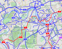
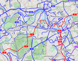 자전거 노선이 렌더링된 모습 |
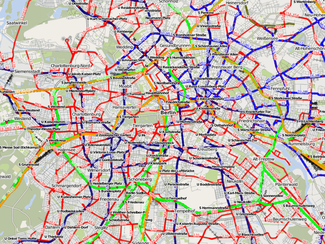 버스 노선이 렌더링된 모습 |
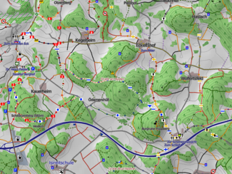 도보 노선이 렌더링된 모습 |
태그
| 키 | 사용 | 값 | 설명 |
|---|---|---|---|
| type | ! 필수 | route | 관계가 노선에 해당한다는 것을 가리킵니다. |
| route | ! 필수 | road(도로) / bicycle(자전거) / foot(도보) / hiking(하이킹) / bus(버스) / trolleybus(트롤리버스 - 전차선을 이용해 운전하는 버스) / ferry(페리) / detour(우회로) / train(열차) / tram(트램) / mtb(산악 자전거) / horse(말) / ski(스키) / snowmobile(스노모빌 - 극지방에서 용이하게 이동하기 위한 차량) / inline_skates(인라인 스케이트) | 도로(예를 들어, 유럽의 A7 고속도로를 구성하는 도로 등), 자전거 노선, 하이킹 노선 등등. (#Route relations in use 참조) |
| name | ‽ 중요 | 이름 | 노선의 이름("부산 3호선", "한강 자전거길" 등). |
| ref | ‽ 중요 | 참조 번호 | 노선의 번호("12", "720", "A1" 등). 상위 관계인 route_master=*가 존재하지 않는 것이 좋습니다. |
| network | ‽ 중요 | ncn / rcn / lcn / nwn / rwn / … | 노선이 속한 네트워크("Seoul Metropolitan Subway System" 등). |
| operator | ? 선택 | 운영자 이름 | 노선을 운영하는 기관이나 회사("Seoul Metro Line 9 Corporation" 등). |
| state | ? 선택 | proposed(제안됨) / alternate(대체) / temporary(임시) / connection(연결) | 때로 노선은 변경될 수 있습니다. 혹은 아직 실물이 있는 노선이 아닌 제안된(proposed) 노선일 수 있습니다. 연결(connection)은 노선 사이를 연결하거나 마을 중앙과 노선을 연결할 때 사용합니다. |
| symbol | ? 선택 | 문양 묘사 | 노선에 표시하는 용도로 사용하는 문양을 묘사합니다. 예를 들어, 독일 Franconia의 Frankenweg에 사용되는 흰색 바탕에 빨간 십자가. |
| colour | ? 선택 | 색 이름 또는 #008080 등 | 웹 색상 코드 포맷을 사용합니다. 대중 교통에 사용하기 편리합니다. |
| description | ? 선택 | 간단한 묘사 | 노선의 특별한 점. |
| distance | ? 선택 | 거리 | 노선의 명목상 거리. 사용자를 위한 정보와 자동 평가를 이용한 완전성를 위해 표시할 수 있습니다. 기본 단위는 km이며, 소수점으로는 쉼표를 사용하지 마십시오. 단위를 명시적으로 작성한 경우에는 공백으로 구분하고 단위 문서에 설명된 값을 사용해야 합니다. |
| ascent | ? 선택 | 오르막 | 노선의 오르막길 고도 차이. 기본적으로 미터(m) 단위이며, 다른 단위를 사용할 경우에는 무조건 표시해야 합니다. 노선에 서로 다른 고도의 시작점·끝점이 있다면, descent도 지정해 주십시오. |
| descent | ? 선택 | 내리막 | 노선의 내리막길 고도 차이. 기본적으로 미터(m) 단위이며, 다른 단위를 사용할 경우에는 무조건 표시해야 합니다. 오르막길과 시작점·끝점의 고도가 서로 다른 경우에만 사용합니다. |
| roundtrip | ? 선택 | yes/no | 노선이 시작한 점에서 끝나는지의 여부. |
구성원
| 선/점 | 기능 | 반복 | 논의 |
|---|---|---|---|
| <empty>/route | ! 1+ | 노선을 구성하는 길. 현재 PTv1에서 사용하는 route 역할 대신 빈 역할로 두어야 합니다. | |
| forward/backward | 노선의 일부 또는 전체가 한 방향으로만 주행해야 한다면, 이 역할은 구성하는 일부 또는 전체의 길을 나타낼 수 있습니다. | ||
| north/south/east/west | 북미에서, 도로 번호 표지판에는 방위( | ||
| link | ? 0+ | 노선에서 나오거나 노선으로 들어가는 연결로(highway=*_link). highway=motorway_link 참고. | |
| stop:<숫자> | ? 0+ | 노선의 버스 정류장이나 철도역 등. 관계에서 구성원들의 순서는 시간표와 일치해야 합니다. 숫자는 정류장의 순서를 유지하는 데 관여하지 않고, 참여자들이 오류를 찾거나 잘못 놓인 정류장을 찾는 용도로 쓰입니다. 원한다면 대신 | |
| stop | ? 0+ | 노선의 버스 정류장이나 철도역 등. 관계에서 구성원들의 순서는 시간표와 일치해야 합니다. | |
| forward:stop:<숫자>, backward:stop:<숫자> |
? 0+ | 특정한 한 방향으로 주행할 때만 사용하는 노선의 버스 정류장이나 철도역 등. 방향은 선의 방향과 관련이 있고, 버스 정류장이나 터미널로 가고 있거나 혹은 떠나고 있거나의 여부를 가리키지 않습니다. 관계에서 구성원들의 순서는 시간표와 일치해야 합니다. 숫자는 정류장의 순서를 유지하는 데 관여하지 않고, 참여자들이 오류를 찾거나 잘못 놓인 정류장을 찾는 용도로 쓰입니다. 원한다면 대신 | |
| forward:stop, backward:stop |
? 0+ | 특정한 한 방향으로 주행할 때만 사용하는 노선의 버스 정류장이나 철도역 등. 방향은 선의 방향과 관련이 있고, 버스 정류장이나 터미널로 가고 있거나 혹은 떠나고 있거나의 여부를 가리키지 않습니다. 관계에서 구성원들의 순서는 시간표와 일치해야 합니다. | |
| platform:<숫자> | ? 0+ | 노선에 속하는 버스·기차 플랫폼. 관계에서 구성원들의 순서는 시간표와 일치해야 합니다. 숫자는 정류장의 순서를 유지하는 데 관여하지 않고, 참여자들이 오류를 찾거나 잘못 놓인 정류장을 찾는 용도로 쓰입니다. 원한다면 대신 | |
| platform | ? 0+ | 노선에 속하는 버스·기차 플랫폼. 관계에서 구성원들의 순서는 시간표와 일치해야 합니다. | |
| guidepost | ? 0+ | 노선을 나타내는 이정표. information=guidepost 참고. | |
| * | Taginfo에서 자주 사용하는 기능을 확인할 수 있습니다. |
노선 종류 (route)
| 키 | 값 | 요소 | 설명 | 렌더링 | 사진 |
|---|---|---|---|---|---|
| route | bicycle | Cycle routes 문서에 어떻게 태그를 붙이는지 설명하고 있습니다. | |||
| route | bus | 노선버스에 사용. Buses 문서 참조. | |||
| route | canoe | 수로를 지나는 카누의 노선. | |||
| route | detour | 항상 사용할 수 있는 우회로. 예를 들면, 독일의 Bedarfsumleitung과 네덜란드의 uitwijkroute 등등. | 
| ||
| route | ferry | 터미널에서 터미널을 잇는 페리. 페리의 항로는 적어도 줌 수준 12(www.openstreetmap.org/#map=<줌 수준>/<위도>/<경도>)에서 점 1개가 보이게 노선을 만들어 주십시오(대략 2~3km마다 점 1개). 그래야지 오프라인 에디터가 bbox 리퀘스트로 노선을 사용할 수 있습니다. | |||
| route | foot | Walking Route - is used for routes which are walkable without any limitations regarding fitness, equipment or weather conditions. | |||
| route | hiking | Hiking 문서에 어떻게 태그를 붙이는지 설명하고 있습니다. | |||
| route | horse | Riding 노선. | |||
| route | inline_skates | 자세한 내용은 Inline 문서를 참조하십시오. | |||
| route | light_rail | 경전철 노선. | |||
| route | mtb | Mountain biking 문서에 어떻게 태그를 붙이는지 설명하고 있습니다. | |||
| route | piste | 겨울 스포츠 시설 내부의 스키 활강용 노선. 예를 들어, snowshoe 또는 XC-Ski trails 등. | |||
| route | railway | 철로의 집합체. 주로 이름이 붙어 있는 경우(경부고속선, 호남선, 채널 터널 등)가 많습니다. | |||
| route | road | 다양한 도로 노선·장거리 노선에 사용합니다. | |||
| route | running | 달리기·조깅 노선. | |||
| route | ski | 스키 트랙. | |||
| route | subway | Route of a metro service | |||
| route | train | 철도 운행 계통. 예를 들어 수도권 전철 1호선, O-Train, 런던-파리 유로스타 등등. | |||
| route | tracks | Railroad track as rail infrastructure. | |||
| route | tram | 트램 노선. Trams 문서에 어떻게 태그를 붙이는지 설명하고 있습니다. | |||
| route | trolleybus | The route of a trolleybus service. | |||
| route | 사용자 정의 | Taginfo 문서에서 자주 사용하는 값을 확인할 수 있습니다. |
This table is a wiki template with a default description in English. Editable here. 한국어 번역은 여기에 있습니다.
대중교통 노선
버스(트롤리버스) 노선
- 주요 문서: Buses
| 키 | 사용 | 값 | 설명 |
|---|---|---|---|
| type | ! 필수 | route | |
| route | ! 필수 | bus trolleybus share_taxi |
|
| ref | ‽ 중요 | 참조 번호 | 노선의 참조 번호. 예를 들어 140, G6000, 서초11, 선운101 등. 부모 관계인 route_master=*가 있는 경우에는 선택 사항입니다. |
| network | ‽ 중요 | 지역/광역 네트워크 | 네트워크의 명칭(약칭). 예를 들어 서울특별시 시내버스, RMV.(Rhein-Main-Verkehrsverbund) 등. 대부분은 참조 번호와 확실히 구별해야 합니다. 부모 관계인 route_master=*가 있는 경우에는 선택 사항입니다. |
| operator | ? 선택 | 운영 회사 | 노선을 운영하는 회사의 상호. 예를 들어 경기고속, 대원고속, 등. |
| name | ? 선택 | 별개의 이름 | 노선이나 경로의 이름. 예를 들어, 부천 시내버스 88 → 여의도 또는 청라-강서 BRT 등. |
| wheelchair | ? 선택 | yes / no / limited | 노선을 운행하는 버스에 휠체어용 경사로나 승강기 등을 갖추고 있는지를 가리킵니다. |
| colour | ? 선택 | red, #FFEEDD | 버스 노선의 공식 색상. 일부 도시에서는 식별자로 사용합니다. |
| public_transport:version | ? 선택 | 1 또는 2 | JOSM으로 추가된 어떤 대중 교통 스키마(schema)가 사용되었는지 나타내는 태그. 1은 이전 스키마를, 2는 새 스키마를 나타내는 태그입니다. |
| duration | ? 선택 | 'mm'(분) 또는 'hh:mm'(시:분) | 노선의 공식적인 주행 시간. |
öpnvkarte.de와 openptmap.org에서 대중교통 노선을 렌더링한 모습을 볼 수 있습니다.
사용 예시:
- 캐나다 퀘벡 시의 버스 노선 82
 캐나다 퀘벡 시의 버스 노선 82 주의: API 0.6 이후로 버스 정류장에 번호를 매길 필요가 없습니다. (이 예시와는 다름) 편집기로 간단히 할 수 있습니다.
철도 노선 (경전철, 지하철, 모노레일 등)
- 주요 문서: Railway
별개의 이름으로 알려진 인프라의 특정 부분(예를 들면 East Coast Main Line)이나 대중에게 식별되는 특정한 식별자 또는 이름을 가진 철도 서비스(예를 들어 Orient Express)를 표현하기 위해 사용합니다. 다양한 목적으로 태그를 사용하는 것을 논의하는 토론이 talk transit에서 진행되고 있습니다. (2009년 8월)
| 키 | 사용 | 값 | 설명 |
|---|---|---|---|
| type | ! 필수 | route | |
| route | ! 필수 | train light_rail subway |
|
| ref | ‽ 중요 | 참조 번호 | 노선의 참조 번호. 예를 들어 1, 분당선 등. 부모 관계인 route_master=*가 있는 경우에는 선택 사항입니다. |
| network | ‽ 중요 | 지역/광역 네트워크 | 네트워크의 명칭(약칭). 예를 들어 수도권 전철, RMV.(Rhein-Main-Verkehrsverbund) 등. 대부분은 참조 번호와 확실히 구별해야 합니다. 부모 관계인 route_master=*가 있는 경우에는 선택 사항입니다. |
| operator | ? 선택 | 운영 회사 | 노선을 운영하는 회사의 상호. 예를 들어 한국철도공사, 신분당선주식회사, 부산교통공사 등. |
| from | ? 선택 | 시점 | |
| to | ? 선택 | 종점 | |
| name | ? 선택 | 별개의 이름 | 노선이나 경로의 이름. 예를 들어 Victoria Line: Brixton → Seven Sisters 등. |
| wheelchair | ? 선택 | yes / no / limited | 노선을 운행하는 열차에 휠체어용 경사로나 승강기 등을 갖추고 있는지를 가리킵니다. |
| colour | ? 선택 | red, #FFEEDD | 열차 노선의 공식 색상. 일부 도시에서는 식별자로 사용합니다. |
| public_transport:version | ? 선택 | 1 또는 2 | JOSM으로 추가된 어떤 대중 교통 스키마(schema)가 사용되었는지 나타내는 태그. 1은 이전 스키마를, 2는 새 스키마를 나타내는 태그입니다. |
| duration | ? 선택 | 37, 2:35 | 노선의 공식적인 주행 시간. |
노선 관계는 하나 이상의 운영 회사가 운영하는 철도 노선을 정의하는 데 사용할 수 있습니다. 예시는 Open Rail Map/NL 참조.
öpnvkarte.de와 openptmap.org에서 대중교통 노선을 렌더링한 모습을 볼 수 있습니다.
사용 예시:
노면전차(트램) 노선
- 주요 문서: Trams
| 키 | 사용 | 값 | 설명 |
|---|---|---|---|
| type | ! 필수 | route | |
| route | ! 필수 | tram | |
| ref | ‽ 중요 | 참조 번호 | 노선의 참조 번호. 예를 들어 1, 분당선 등. 부모 관계인 route_master=*가 있는 경우에는 선택 사항입니다. |
| network | ‽ 중요 | 지역/광역 네트워크 | 네트워크의 명칭(약칭). 예를 들어 수도권 전철, RMV.(Rhein-Main-Verkehrsverbund) 등. 대부분은 참조 번호와 확실히 구별해야 합니다. 부모 관계인 route_master=*가 있는 경우에는 선택 사항입니다. |
| operator | ? 선택 | 운영 회사 | 노선을 운영하는 회사의 상호. 예를 들어 한국철도공사, 신분당선주식회사, 부산교통공사 등. |
| name | ? 선택 | 별개의 이름 | 노선이나 경로의 이름. 예를 들어 Victoria Line: Brixton → Seven Sisters 등. |
| wheelchair | ? 선택 | yes / no / limited | 노선을 운행하는 열차에 휠체어용 경사로나 승강기 등을 갖추고 있는지를 가리킵니다. |
| colour | ? 선택 | red, #FFEEDD | 열차 노선의 공식 색상. 일부 도시에서는 식별자로 사용합니다. |
| public_transport:version | ? 선택 | 1 또는 2 | JSOM으로 추가된 어떤 대중 교통 스키마(schema)가 사용되었는지 나타내는 태그. 1은 이전 스키마를, 2는 새 스키마를 나타내는 태그입니다. |
| duration | ? 선택 | 37, 2:35 | 노선의 공식적인 주행 시간. |
öpnvkarte.de와 openptmap.org에서 대중교통 노선을 렌더링한 모습을 볼 수 있습니다.
사용 예시:
도로 노선
- 주요 문서: Key:network
- 주요 문서: :Category:Tag descriptions for key "network"
| route | network | 설명 |
|---|---|---|
| road | e-road | European E-road network |
| road | US:I | Interstate Highways Relations, USA |
| road | US:US | United States Numbered Highway Relations, USA |
| road | US:xx | State highways in the United States, where xx is the state's postal abbreviation. Many states also have county route networks, and some have several tiers of state-owned roads. |
| road | BAB | German Autobahn |
| road | ca_transcanada | Canadian Trans-Canada highways |
| road | ca_on_primary | Ontario primary highways |
| road | pl:national | Polish Road Network - national roads |
| road | by:national [1] | Belarusian Road Network - national roads |
| road | ro:DN | Romanian Road Network - national roads |
| road | AR:national | Argentine national roads |
| road | AR:provincial | Argentine provincial roads |
| road | ru:national | Автодороги России - national roads |
| road | BR | Brazilian Federal Highways |
| road | BR:xx | Brazilian state highways, where xx is replaced by a state code (RJ = Rio de Janeiro, MG = Minas Gerais, etc.) |
| road | bg:national | Bulgarian Road Network - national roads |
| road | gr:national | Greek national roads |
| road | gr:provincial:nn | Greek provincial roads, where nn is the prefecture's ISO code. |
| road | HK | Hong Kong Strategic Routes |
| road | JP:national | Japanese national roads |
| road | JP:prefectural | Japanese prefectural roads |
| road | ph:nhn | Philippine national highway network |
| road | na | Namibian roads |
| road | ua:national | Ukrainian national roads |
| road | za:national | South African national roads |
| road | za:regional | South African regional roads |
Detours
| route | Description |
|---|---|
| detour | Local detours (used in the Netherlands and Germany). Detours are routes that avoid traffic jams on motorways, usually leading from one exit to the next. |
자전거 노선(산악 자전거 포함)
- 주요 문서: Cycle routes
| 키 | 사용 | 값 | 설명 |
|---|---|---|---|
| route | ! 필수 | bicycle / mtb | "bicycle/mtb" 형태가 아닌 "bicycle" 또는 'mtb"로 사용해야 합니다. |
| network | ! 필수(route=bicycle)
? 선택(route=mtb) |
통상적인 cycle route 태그에 따라서 도로망을 국제 노선, 국유 노선, 지역(regional과 local) 노선으로 명시합니다. | |
| icn | 국제적인 자전거 도로(International cycling network): 대륙 횡단 사이클링에 사용하는 장거리 노선. | ||
| ncn | 국유 자전거 도로(National cycling network): 국가 횡단 사이클링에 사용하는 장거리 노선. | ||
| rcn |
지역 자전거 도로(Regional cycling network): 지역 횡단에 사용. 벨기에와 네덜란드에서는 자전거 교점 네트워크에 사용합니다. | ||
| lcn | 지역 자전거 도로(Local cycling network): 소규모의 지역 자전거 노선에 사용. 도시를 가로지르는 여행자 노선이나 우회로에 사용됩니다. | ||
| ref | ? 선택 | 참조 번호 | 참조 번호는 NCN 4: 4처럼 숫자만 적는 것이 좋습니다. network 태그는 이 타입과 차이를 보이기 때문에, ref로만 사용하고 ncn_ref 등으로 사용하지 마십시오. |
| state | ? 선택 | proposed | 노선 중에는 비공식 노선도 몇몇 있으며, 협의 중이거나 개발 중일 수도 있습니다. 지도가 이 노선을 점선 등으로 다르게 렌더링하게 할 수 있습니다. |
사용 예시:
- Part of UK NCN Route 4
 Part of UK NCN Route 4
 - Part of London Route 5
 Part of London Route 5
Walking routes (also hiking and pilgrimage)
- 주요 문서: Walking Routes
Hiking routes are extensively mapped with route relations, and the Waymarkedtrails map will render route relations following this proposal and the osmc:symbol=*
Hiking routes are rendered for selected areas in Germany in a hiking and trail riding map (German). The tags required for rendering are:
| Key | Presence | Value | Description |
|---|---|---|---|
| type | ! Required | route | |
| route | ! Required | hiking | Typically longer or more strenuous routes, usually on unpaved paths. |
| foot | Typically easier routes, usually on paved surfaces. | ||
| network | ! Required | iwn | International walking network: long distance paths used for walking routes that cross several countries, for example the Camino de Santiago |
| nwn | National walking network: long distance paths used for walking routes that cross countries | ||
| rwn |
Regional walking network: used for walking routes that cross regions. In Belgium and the Netherlands this tag is used for the walking node networks | ||
| lwn | Local walking network: used for small local walking routes. Could be touristic loops or routes crossing a city | ||
| name | ‽ Important | Meaningful route name suitable for identifying this route. | |
| symbol | ? Optional | Verbal description of the route marker symbols. | |
| osmc:symbol | ? Optional | Coded description of the route marker symbols. | |
| pilgrimage | ? Optional | yes / no | Whether the route is used for pilgrimage. This qualifies the use of a hiking/foot route; as opposed to creating a new route type with route=pilgrimage. |
Inline skating routes
- 주요 문서: Inline skating
Inline Skating routes have been mapped mainly in Switzerland EN:Switzerland/InlineNetwork and the Netherlands with route relations. Lonvias Skating map will render such routes.
| Key | Presence | Value | Comment |
|---|---|---|---|
| route | ! Required | inline_skates | |
| network | ! Required | international / national / regional / local | Specify the network as a international route, national route, a regional route, or a local route |
| ref | ? Optional | Reference | References work best on the map if just the number is used, so for national 4: 4. The network tag correctly distinguishes the type, so just use ref. |
| state | ? Optional | Proposed. Routes are sometimes not official routes pending some negotiation or development; the map renders these routes as dotted. |
Some examples in use:
- Part of Swiss National Route 3
 Part of Swiss National Route 3
 - Route 72 around the Greifensee
 Route 72 around the Greifensee
 - Skating network in Midden-Delfland, Netherlands
 Skating network in Midden-Delfland, Netherlands
Others
This is a table with possible route tags being used right now:
| route | Description |
|---|---|
| fitness_trail | For a fitness trail with extra exercise stations |
| horse | See riding |
| inline_skates | Inline skate routes are named or numbered or otherwise signed routes for inline skating. |
| running | Used for marked running routes, usually 2–20km, that are used for exercise |
| snowmobile | For snowmobile routes. Either between two destinations or a collection of routes operated by someone |
| taxi | See also: route=share_taxi |
| trolleybus | See bus |
| cycling | Used for cycling events (like stages of the Tour de France). For (recreational) cyclenetwork use bicycle |
| historic | Historic routes, such as horse-pack trails used for postal routes, ancient roads, etc. Often parts are lost. Please include an appropriate historic=*-value. |
| Please add here |
How to map
Multiple routes sharing the same ways
Especially with bicycle routes, often multiple routes run along the same ways for a far distance. There exist so many different bicycle route networks that are operated by different entities that it is not unusual that some of these networks overlap. The EuroVelo routes, for example, use the existing infrastructure in many countries. There are two practices at the moment, if segments of multiple routes share the same way.
- Add the ways to all relations of the routes that they belong to.
- Split the routes into part relations and make super relations (relations that don’t contain ways but instead other relations). Then add the segment that is shared by the routes to all of them.
Both practices each have advantages and disadvantages.
Adding the ways to multiple route relations
- When many routes share one path, it can be a lot of work to map a new part of the route, because you have to add the ways to all relations.
- People might not see that the path also is used by other routes and might forget to apply their changes to all relations. Thus the data may become inconsistent.
- This is probably the easier way, as it is somewhat hard for beginners to split relations into parts and to find out which part they have to edit.
- Relations might become very big, which makes it hard to work with them (analyzers need more time to process them, drawing them into the map will take a lot of JavaScript CPU time).
- If you don’t use super relations at all, you also have to add alternative routes and excursions to your relation. This makes it hard for analyzers and tools to understand the route. Role=excursion and role=alternative have been suggested, but they still don’t say which way belongs to which excursion (if there are multiple ones).
- It is the purpose of relations to group objects. When two primary roads share the same street at some section, we don’t create two ways that share the same nodes. So we shouldn’t create two relations that share the same ways.
Creating super-relations for routes
- Current renderers (like the CycleMap) don’t support super-relations, so they don’t show the ref and the network tag of a super-relation. Currently, all these tags have to be added to all part relations, which is a lot of work (especially as the parts need to have the different refs of all the routes they belong to).
- It is said to be good mapping practice to keep relations one way. So alternative routes and excursions need to be put into a different relation. So you often need a super-relation even without splitting the route into parts.
- Tools and analyzers (like the OSM Relation Analyzer, especially the GPX export function) don’t support super-relations yet. This makes it hard to analyze a route as a whole (which is important, for example, to calculate how much of a route already has been mapped). (Note: OSM Route Manager supports subrelations)
- There is no documented convention on how to handle super-relations. On first glance it appears simple--just take over all tags to all members--but it is not. There are tags where this makes no sense or which change the context and meaning when handed over to a member relation; e.g., distance or note. The same applies to roles other than in base relation, e.g. forward/backward.
- Super-relations can become very confusing when a relation belongs to multiple super-relations or a way belongs to multiple relations. In that case it is no longer deterministic from which relation a certain relation or way will receive its tags.
- When someone maps a new route, they might have to split other routes that share ways with it. People editing these other routes might get confused when the number of subrelations keeps changing the whole time.
- Current editors miss advanced relation editing features, such as “Split relation” (and also super-relation rendering). Things can get very confusing when one route consists of hundreds of small part relations.
- One motto of OSM is "Don't map for the renderers". If it is considered the more natural way of mapping to create super-relations, then the missing support in the renderers and tools should not stop us from doing so.
- Consider that super-relations are not necessarily included when requesting a set of data from the server. So depending on whether or not super-relations were included, the data is interpreted differently. As you cannot tell from a way or relation whether it is member of another relation, you never are quite sure whether you are seeing all the relevant data.
- It is common sense to create super-relations if one complete route is part of another route (like the German D6 is with EuroVelo EV6). If EV6 now shares only a part of another way in another country, we will have to create segments anyway (else we end up with a relation that contains both sub-relations and ways). We should either use the one method or the other.
- People need to know only the route that they are mapping. When someone maps the German D6 route, he doesn’t even need to know the EuroVelo network (as EV signs might not exist in his area), because, as with a super-relation, his part of the route gets added automatically to all parent relations. This fits the OSM concept better: When everyone maps the places and things he knows, a complete map of the world evolves.
At the moment it seems to be practice to create part-relations, if the shared segment is relatively big compared to the total length of a route. For a national bicycle route, 20 km might be a good limit. For shorter parts the single ways might be added to all relations they belong to. (Of course this is only a rule of thumb. Nothing of this is the official way of mapping.) It also might be important how many different way objects a segment consists of in OSM. It might be not very useful to create segments, if the route consists of motorways (as they only contain of a few, long ways), while bicycle routes often go through cities and residential areas where many ways would have to be added if there were multiple relations.
Another point when deciding which tagging method to use is to find out if the routes use the same ways only by coincidence. Thus, if one route is changed, the other route likely still will be using the old way, so using part-relations would not be appropriate.
Size
Common practice is not to create route relations with more than 250–300 members. If you need to create bigger relations, which could happen easily, make several reasonable-sized relations and unite them in a super-relation as mentioned above. Reasons:
- Keep the relations editable.
- Avoid conflicts. The bigger the relation the more likely it is that two users are working on it at the same time.
- Save the server resources.
There is also a list of Monster Relations.
Bus routes and roundabouts
Bus routes passing through roundabouts are mapped in one of these two ways:
- The whole roundabout is included in the route relation.
- The roundabout is split and the part used by the bus route is included in the route relation.
There is no consensus among the OSM community regarding which method is recommended. The choice of method 1 or 2 has no effect on Garmin devices because split roundabouts are re-joined by mkgmap. It is also possible to re-join split roundabouts in Mapnik although this is not done for the rendering of the main map. Software developers should note that if the precise route is required and method 1 has been used, the details will need to be deduced from the positions of the entry to, and the exit from the roundabout; and also from the position of a stop, if the bus serves a stop on the roundabout. (In some cases a bus may make more than one full circuit of a roundabout.)
Step by step guide
How to create a new route (it is slightly different if you want to add ways to an existing route).
Potlatch
- Ensure all ways that the route runs along exist and are appropriately tagged (e.g., highway=footway)
- Select the first way and click on the second symbol on the right side, which looks like two chain segments.
- Select a relation from the drop-down menu, if there is an existing relation in this area that is appropriate. If the existing relation you want to choose is far away, use the search function. Otherwise, select Create a new relation and click Add.
- Add a type tag with the value route.
- Add additional tags as needed. (Use the + button)
- Click OK.
- The relation has been added to the way. The grey box to the right of the relation details and to the left of the X is the input field for the way's role within the relation. See the Members section above for details of roles within the route relation type.
- Repeat steps 2–4, selecting the appropriate relation (the one just created) in step 3.
JOSM
- Ensure all ways along which the route runs exist and are appropriately tagged (e.g., highway=footway)
- Make sure the relation pane (
Alt+Shift+R) is open - Select
Newin the relation pane to create a new relation - Fill in the appropriate tags in the dialog that pops up, adding at least type=route and preferrably name as well with a name for the route
- Click
OK - Now select some or all of the ways you would like to add to the relation using the normal select (
S) tool, then clickEditin the relation pane with your relation highlighted. The relation editing dialog will pop up - Click
Add selectionin the relation dialog to add the selected ways to the relation.
Please list applications here that are able to navigate on an existing relation:route.
- cycle.travel uses route relations (of type=bicycle and type=road) to influence weighting for route selection.
Notes
Helping tools
- OSM Relation Analyzer (possible to search for relations by name)
- OSM Route Manager
- Hikingbook.pl automatically creates route descriptions and maps, as well as POI directory
- Rel2gpx exporter
| ||||||||||||||||||||||||||||||||||||||||||||||
