JA:サイクリングルート
| 説明 |
|---|
| サイクリングルートまたは自転車ルートは、名前や番号やその他の標識があるルートです。道路や小道や歩道に沿っていたり、専用の自転車道であったりします。 |
| グループ: ルート |
| 適用できる要素 |
| 依存するタグ |
| よく併用されるタグ |
| 状態:事実上の標準 |
| ツール |
英語版の記事の内容が分かる方は、翻訳の完成にご協力ください。このウィキの翻訳方法についての説明をお読みください。
現時点では、誰もこの記事の翻訳に取り組んでいないようですので、あなたが取り組めます。
自転車ルートまたはバイクルートです。
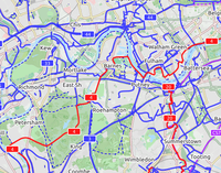
自転車地図の描画
自転車地図やバイク地図はどのように見えるのでしょうか?
An international cycling map created from OSM data is available, provided by Andy Allan. The map rendering is still being improved, the data are updated every few days. It shows National Cycle Network cycle routes, other regional and local routes, and other cycling-specific features, such as:
|
| CyclOSM A free cycle-oriented map with more features than OpenCycleMap. See its wiki page CyclOSM. |
| Waymarked Trails: Cycling by Sarah Hoffman is a layer superimposed over mapnik (Standard Map Layer) which shows marked cycle routes around the world. Updated minutely, it renders actual routes without the state=proposed tag. Therefore no proposed routes (or proposed numbering protocols) are displayed. |
自転車ルートネットワークのタグ付け
現在は、国際、国、広域、地域と4つの階層のレベルが使われています。ルートは以下の表に従って、個々のウェイにタグ付けされている可能性があります。他にもRelations/Routes#Cycle routes (also mountain bike)の通り、リレーションを使用しても自転車地図にレンダリングされます。
普通はリレーションを使用して自転車ルートをタグ付けした方が、この表のタグ付けよりも優れています(後述のリレーションのタグ付け方法を参照)。ただし、リレーションを作成する前に、既に存在しないかを確認してください。
| タグ | 要素 | 説明 |
|---|---|---|
| icn=yes | 道路や小道が国際自転車ネットワークルートの一部であることを示します。 | |
| ncn=yes | 道路や小道が国の自転車ネットワークルートの一部であることを示します。 | |
| ncn=proposed | 道路や小道が計画中の国の自転車ネットワークルートの一部であることを示します。 | |
| rcn=yes / proposed | 上記と同様ですが、広域自転車ルートです。 | |
| lcn=yes / proposed | 上記と同様ですが、地域自転車ルートです。 | |
| icn_ref=番号 | 番号がルート番号である国際的なの自転車ルートです。icn=yesを含みます。 | |
| ncn_ref=番号 | 番号がルート番号である国の自転車ルートです。ncn=yesを含みます。 | |
| rcn_ref=番号 | 番号がルート番号である広域自転車ルートです。rcn=yesを含みます。 | |
| lcn_ref=番号 | 番号がルート番号である地域自転車ルートです。lcn=yesを含みます。 |
以前はroute=ncnが使用されていましたが、現在は他のルートとウェイを共用したときに衝突するため、非推奨になっています。
自転車ノードネットワークのタグ付け
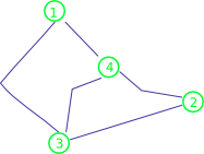
自転車ノードネットワーク(例えばこちら)はオランダやベルギーでは一般的ですが、イギリスにはありません。自転車道に参照記号がついている標準的な自転車ルートネットワークと比較して、自転車ノードネットワークでは交差点に番号が付いています。ウェイに沿った標識は向かっている交差点を示しているので、1つの自転車道の標識が、ある方向が「1」、逆方向が「4」というようになっています。
We use the same tags, but apply the reference numbers to the junction nodes. The same principles could in principle be used for national and local cycle node networks, but currently regional is in main use in both Belgium and The Netherlands.
| タグ | 要素 | 説明 |
|---|---|---|
| rcn=yes | Designates that a road or path is part of a Regional cycle node network | |
| rcn_ref=number | Designates that the node represents a numbered junction in the regional cycle node network |
Please refer to the pages below for country specific details:
An expanded way of tagging cycle node networks, which is currently already being employed in parts of Belgium and The Netherlands, is described at Cycle Node Network Tagging.
リレーション
It is preferred to tag the cycle routes using relations instead of tagging the ways. But please check that a relation doesn't already exist for your chosen route before creating one. Links to country-specific overview pages of cycle networks are below.
The tags on the relation are slightly modified from the standard tags. An example cycle route relation would have the following tags:
| タグ | コメント |
|---|---|
| type=route | |
| route=bicycle/mtb | See JA:マウンテンバイク for details on tagging mountainbike routes. |
| network=icn/ncn/rcn/lcn | Specify the network as an international route, a national route, a regional route, or a local route, as per the normal tagging of cycle routes. For tagging mountainbike routes more specific look here マウンテンバイク |
| cycle_network=* | (optional) In countries that have (for instance) multiple regional route networks, this tag indicates the specific route system, much the way network=* does on road route relations. |
| ref=number | (optional) NCN, RCN, and LCN references work best on the map if just the number is used, so for NCN 4: "4". The network or cycle_network tag correctly distinguishes the type, so just use "ref" and not "ncn_ref" or similar. |
| name=* | (optional) The name of the route e.g. Jubilee Cycle Way |
| state=proposed | (optional) Routes are sometimes not official routes pending some negotiation or development -- the opencyclemap rendering shows these routes dotted. |
| distance=distance in km | (optional) The distance covered by a route in km |
| ascent=ascent in m | (optional) The ascent covered by a route in meters. If a route has start and end point at different altitude use descent too |
| descent=descent in m | (optional) The descent covered by a route in meters. Use it only if it differs from the ascent (different altitude at start/endpoint of a route). |
| roundtrip=yes/no | (optional) Use roundtrip=no to indicate that a route goes from A to B. Use roundtrip=yes to indicate that the start and finish of the route are at the same location (circular route). |
Relation role: Cycle routes sometimes have different paths depending on the direction you are travelling. In this case, ways in the relation should have a role of forward or backward as described in Relation:route#Members. The direction is rendered on the cycle map (example).
マウンテンバイクのルート
- See Mountainbiketours for cycle routes that are primarily for mountainbikes.
- Additionally, have a look at the マウンテンバイク portal for tagging guidelines to ways suitable for mountainbiking.
使い方
Since the tagging is generic, it is up to each country to decide how to map the cycle networks that exist in their country onto the hierarchy of national/regional/local.
Transnational
EuroVelo
The EuroVelo (wikipedia) network consists of 13 routes, with a total distance of 72,978 km, developed by the European Cyclists' Federation. The route references are in the format EVxy, e.g. EV12 for the North Sea Cycle Route.
See the European Wikiproject EuroVelo for further details.
Greenways
The Greenway Project aims to build an international network of bicycle and other non-motorized trails focussed on Eastern European countries. The motivation is to provide local people and visitors with access to natural and cultural heritage areas.
See the European Wikiproject Greenways for further details.
オーストラリア
西オーストラリア
See: Western Australia
オーストリア
See: WikiProject Austria/Radwege
ベルギー
See the Belgian cycle route conventions and their project page for full details.
バルト三国: リトアニア、ラトビア、エストニア
The project BaltiCCycle.eu collects all information on cycling in the Baltic States (BaltiCCycle.eu_Routes)including the International Routes EuroVelo, R1, Iron Curtain Trail, the National Cycling Routes in Estonia (EstoVelo)
カナダ
- Canada#Trans Canada Trail
- Fr:Route verte (Québec)
チェコ共和国
デンマーク
See: Da:Bicycle/Network-Routes
フランス
フィンランド
See: Fi:Valtakunnalliset pyörämatkailureitit
ドイツ
See DE:Bicycle/Fahrradroutensammlungen for overview of German cycle route collections.
ハンガリー
See WikiProject Hungary/Kerékpárút for overview of Hungarian cycle route collections.
アイスランド
See WikiProject Iceland/Cycleways for an overview of Icelandic cycle routes and ways.
イタリア
See WikiProject Italy/Ciclovie for an overview of Italian cycle route collections.
ルクセンブルク
See WikiProject Luxembourg/Cycle Route Network for an overview of Luxembourgish cycle route network (Pistes cyclables).
オランダ
Zie: Fietsroutes.
ノルウェー
See WikiProject Norway/Sykkelruter i Norge.
スロバキア
See Slovak Cycling Routes for full details.
スペイン
See Spanish Cycling Network for full details.
スウェーデン
See Swedish Cycling Network for full details.
スイス
See Swiss Cycle Network and Swiss Mountain Bike Network for full details.
イギリス
Note: CycleStreets is a major user of cycling-related data in the UK area. Information on its interpretation of tags may be of interest (and the developers strongly welcome feedback on this).
CycleStreets has produced a fully-designed and downloadable 'Get mapping' guide, with particular focus on adding data for improving bicycle routing.
| ネットワーク | タグ付け | 例 |
|---|---|---|
| Sustrans' National Cycle Network National routes (red numbers). See WikiProject United Kingdom National Cycle Network for a list and to see if a relation has already been set up. References shouldn't be given a prefix i.e. use 54 and not N54. Remember to map the mileposts too - see WikiProject_United_Kingdom_Sustrans_Mileposts. | Add to an existing relation or create a new relation or use ncn=*, ncn_ref=* | 
|
| Sustrans' National Cycle Network Regional routes (blue numbers). See WikiProject United Kingdom National Cycle Network too for a list and to see if a relation has already been set up. References shouldn't be given a prefix i.e. use 47 and not R47. | Add to an existing relation or create a new relation or use rcn=*, rcn_ref=* |  (Sign showing both national and regional spur). |
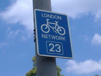
| LCC's London Cycle Network. See WikiProject United Kingdom London Cycle Network. | lcn=*, lcn_ref=* | 
|
| Ipswich, other towns etc. local cycle networks | lcn=*, lcn_ref=* | |
| The National Byway | network=rcn See National Byway. |

|
| The Pennine Bridleway, a 209 km route parallel to the Pennine Way hiking trail | ||
| The Scottish Borders region has several signed long distance routes: the Border Loop (402 km), North Sea Cycle Route, Southern Borders Loop, 4 Abbeys Cycle route, Tweed Cycleway. There is also a signed local network depicted by coloured circles | Border Loop 149461 4 Abbeys 3159944 Tweed cycleway 3160049 |

|
アメリカ合衆国
See United States Bicycle Networks and U.S. Bicycle Route System for full details.
関連ページ
- Bicycle tags on OSM A slippy map that renders cycling related OSM tags
- Cheltenham Standard - a discussion of how to tag the suitability for cycles of all-purpose roads
- Cycle_routes/cyclability
- amenity=bicycle_parking
- amenity=bicycle_rental
- shop=bicycle
- vending=bicycle_tube
- barrier=cycle_barrier
- reference=* - motor vehicle routes
- crossing=*
- WikiProject_U.S._Bicycle_Route_System
- WikiProject Europe/EuroVelo


