Tag:tower:type=observation
Jump to navigation
Jump to search
 |
| Description |
|---|
| Observation tower |
| Rendering in OSM Carto |
| Group: man made |
| Used on these elements |
| Requires |
| Status: de facto |
| Tools for this tag |
|
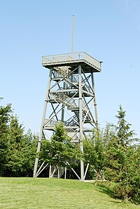
An observation tower is a structure used to observe surroundings and offers a good view.
How to map
Set a node ![]() or draw as an area
or draw as an area ![]() along the outline and tag it with
along the outline and tag it with
Tags which can be used in combination
name=*- Name of the towerdirection=*- can be used for the field of view,direction=0-360for full 360° panoramic viewtourism=viewpoint- Publicly accessible towers are often alsohistoric=yes- If the watchtower is historicalaccess=yes- Public access possibleopening_hours=*- Describes when something is open or closed in a standard formatheight=*- Height in metersstart_date=*- Date when feature opened or the construction of the feature finishedheritage=*- Site/building/object registered by an official heritage organisationele=*- Elevation at the foot of the tower above sea level, in metresdisused=yes- when it is no longer used or is blockedstep_count=*- can be added to indicate the number of steps, useful especially for cases where number of steps is low and sparse. It indicates in such cases that steps are less significant obstacle than indicated just by their length.
One use of an observation tower is a tower that used to watch for and report forest fire (Tour de surveillance des feux de forêt (fr))
This feature is listed as being used in CanVec in the CanVec: Buildings and structures (BS) feature theme.
Similar tags
tower:type=watchtower- Watch Towertower:type=defensive- Fortified defensive towerleisure=bird_hide- objects for watching birds, may offer more limited view and be enclosed