Talk:Camino de Santiago
Relation: "Camino de Santiago"
- ist this still useful? -- braegel 12:48, 7 June 2009 (UTC)
- I suggest to use the relation "Camino de Santiago" for creating a network of all variations of the Camino. I started my Camino at Düren, Germany and currently I am at Esneux, Belgium. This part of the Camino is called Via Mosana. Cheers -- braegel 15:29, 2 June 2009 (UTC)
- Via mossana or Via mosana ? See http://www.radiocamino.net/via-mosana ...
- Wow, good question ... i'll think about that! -- braegel 19:28, 4 June 2009 (UTC)
- Jeay you are right! Thanks a lot.
- I hope we will receive a lot of gpx. Have a good pilgrimage. Ultreia FrViPofm 21:01, 2 June 2009 (UTC)
- Thanks for editing the Main Page. It looks great now. Cool tools! I already marked parts of my journey from Düren, Germany to Thimister-Clermont, Belgium as a relation called "Camino de Santiago". Is there a quick way to change this relation according to the example on the mainpage? --braegel 11:18, 7 June 2009 (UTC)
- This intercept from Düren to Aachen ist not Part of the Via Mosana --braegel 12:44, 7 June 2009 (UTC)
- 35121
 35121
35121
- We have here in France a highway=path called "Camino de Santiago" here : http://www.openstreetmap.org/browse/way/35223943. Could you add this somewhere in your tables ? -- Pieren 09:14, 3 August 2009 (UTC)
- Done, included in the Via Podiensis Via Podiensis FrViPofm 10:18, 31 August 2009 (UTC)
- Done, included in the Via Podiensis
- Don't forget the Swiss and German (Projekt_Jakobsweg) routes. These already are partially mapped and have relations. SK53 10:16, 3 August 2009 (UTC)
- For swiss ways, the Via francigena can be added to the Via Romea Francigena. For swiss part of the Camino, i've found no relation, can you be more explicit or can you include the relation in the table ? FrViPofm 10:18, 31 August 2009 (UTC)
Relation hiking, relation biking
The map : http://sautter.com/map/?lon=-1.80382&lat=42.6765&zoom=14&layers=00B000TFFFFF is an example of conflict between hinking and biking. the highway=path has the tag name=Camino de Santiago and the highway=footway is included in the relation Camino franès. Obviously the footway is from a GPS track (made by bike) included without cnsideration for existing roads.
I think we need two relations for the Camino especialy on the Camino francès, one for hiking pilgrimage, one for people making the pilgrimage by bike. I suggest to tag them route=pilgrimage, foot and route=pilgrimage, foot, bicycle FrViPofm 10:33, 31 August 2009 (UTC)
change the relation-defintion ?
In germany i supported the Projekt Jakobsweg in hope to collect more relation-data. in germany even exists some special hiking maps [2],[3] but they did not show the relations of Jakobsweg.
I startet a posting in the german mailinglist and the openstreet-map-forum in hope to create a consens and the most reaction would like to use following tags for the Jakobsweg-Relations:
what is your opinion and would you like to retag the relations even ???
- [1] http://topo.geofabrik.de/
- [2] http://osm.lonvia.de/hiking.html?zoom=14&lat=47.34297&lon=8.6654&layers=TBT
regards Jan :-)
- *route=hiking/bicycle + pilgrimage=yes FrViPofm 15:24, 10 December 2009 (UTC)
- route=bicycle ... for the different declarations ??? --Jan Tappenbeck 10:02, 11 December 2009 (UTC)
- I have not understood the question... The EV3 is the pligrim road to Santiago by bicycle, The EV5 is the Via Romea Francigena by bike. And the Spanish part of the way to Santiago is very bad, mixing hiking and biking. I have introduced the different relations to distinguish the different ways of pilgrimage and I think they must be re-tagged using he proposed sheme : route=hiking for foot, route=bicycle for bicycle. FrViPofm 10:27, 11 December 2009 (UTC)
- route=bicycle ... for the different declarations ??? --Jan Tappenbeck 10:02, 11 December 2009 (UTC)
Where could you find EV3 signs in Spain? I never saw this, but of course sometimes a different way marked for hiking and bicycle with the typical yellow arrows. An estimated 80% uses the same track. MTBs use up to 99% of the hiking trail (imho not the Cebreiro steep part). Well I think it is a good idea to distinguish hike and bike but I am not able to contribute much detail. Even what we call Camino Frances by foot is not one but several ways and if you have a good guidebook they will also show you some additional unmarked tracks e.g. to enter or cross bigger cities. I tend to integrate such (marked) alternatives into the main relation, but of course not such suggestions like walking on the main road instead of a block away on quieter roads because one guide thought that would be faster and less complicated. --Ottokar55 01:19, 29 January 2010 (UTC)
- Hi Ottokar. Great job on the page, and on the ways !
- The EV3 starts far before Spain ! A part is mapped in France 152746. 152746. Very different from the Via Turonensis and using parts of other EuroVelo's. So it needs to be mapped differently. (and rendered one on lonvia, one on opencyclemap)
- In Spain, they are in fact several places where the bikers and walkers are on different ways. Some examples :
- If with our mapping we can help having people at the right place and being peaceful...
- You are right : the pilgrimage is not walking on the VERY way ! I've read from an English man, a old pilgrim who said that in the past, before the pilgrimage went popular, you took the way you want: the pilgrimage was going from shrine to shrine. Now when you are not on the VERY way, people think you are crazy, you are lost, you are not a real pilgrim because you are not on the real way...
- But on OSM, we cannot add the variants in the main route for we must be able to produce a thin, single, long GPX, kml..., We must be able to use it for statistics, calculation... What if the compute says the Camino is twice its real length? (762,88/703km actually).
- It's why I have started the section variant ways. They can be mapped also with network=iwn/nwn/.... Maybe with a variant=yes... and be rendered with the same style but dotted, for example.
- It's also why I don't forget to include the main church in the relation. The pilgrimage is going from shrine to shrine
- Ultreia !
- --FrViPofm 21:39, 29 January 2010 (UTC)
- The bicycle route should be differently marked, if there is an official option which I am not remembering that often in Spain.
- But I'm sure they never ever called it EV# there. In the future that might be different, since they are developing bicycle
- lanes inside the towns now.
- >example 2 [3] I remember the trail and have respect if some bikers are doing this. Was there a marked alternative for the bike? No idea.
- Most MTBikers will do as always, following the paths they can manage with their skills. If they see the nice track along a busy road imho even
- normal bikers will follow the track, no matter what the map tells them.
- Who told us the "exact" distance for the Camino Frances? It varies from 720 to 800km in most guide books and that's never exact to the km,
- because of so many offical choices on the track.
- > But on OSM, we cannot add the variants in the main route ...
- I totally disagree. We have to map it like it is in real live and how it is shown in normal maps/sketches/guide books etc.
- Marking "wrong" because the tools are not working properly is not the right way. Calculating the length is nice to see the
- process, but that's all. A gpx as well as a relation can have a lot of segments, don't worry about that.
- The goal is a usable map, not a generator for GPX Tracks, but if so the GPX would be as incomplete as the
- marked way ignoring any alternative.
- And I don't want to decide wether trail 1, 2 or 3 is the right and only one which belongs to the relation Camino X. e.g. can you tell which way
- is better (right ...) here [4] in Galicia?
- Both are marked trails, even if I prefer the San Xil route with less termac roads, some people pass Samos and both are 100% Camino frances.
- To make it more complicate San Xil to Montan has 3 variations on that short stretch or even 4 (the road, for some cyclists, who fear the rocky trail).
- Not to mention the 3 trails from Cebreiro. Most people don't follow the signs so they continue on the road (#1), the hardly noticed marks
- indicate the track passing the front door of the Albergue towards a trail that keeps the level (#2) and who is trusting the first arrow that I
- remember walks up a hill on a different track (#3) which meets #2 later on the way down. I am not sure if #3 has more markers in between,
- but last time more folk came down that way than on #2.
- So which rule we want to apply (e.g. used by most people, best marked ...)? Whatever we do, it makes the process of marking a long distance route
- more complicated and less understandable to users.
--Ottokar55 23:54, 29 January 2010 (UTC)
- Maybe you forgot that OSM is not first a map but a database. I'm not skilful in GIS, nor in topology, but I think a route must have a single continuous path for being a valuable geographic object. It is why models are being developed for route=bus, public transport, and other complicated netwoks. Maybe we must change the model for the Via Francès and make it a super-relation with a type=network, including, by places, variants as sub-relations.
- I never said there were a true and a wrong way. But we must keep single pathes into the routes. When I spoke about the use of variants it was because the actual model for the Via Francès is a simple relation route. And making variant routes was an elegant way to map. We can adopt an other model...
- In the same way, even if sometimes I would see bikes and hikers on different ways, on the ground, for making the walking more comfortable for both of them. The mapping of them in different relation (having common parts, sharing roads) is also a question of logic : route=bicycle and route=hiking are different objects in OSM, whatever is the reality on the ground.
- What is the exact distance of the way ? It doesn't matter. But OSM must be able to give the length mapped because OSM is, firsts, a kind of GIS database. And at the end, one should compute his way according to the variant chosen.
- --FrViPofm 23:45, 5 February 2010 (UTC)
For the length I have no doubt that the counting actually works even with segmented relations. The math has to count from GPS knot to another knot inside the relation and actually segmented routes are very common, while a complete hiking route is very rare. Anyway the counting and manipulating of data from the database shouldn't be part of the database itself but of some frontend, like the relation analyzer.
Sometimes it would be handy to have a "hiking+biking" route, but in general it will be a different route in reality and therefore the different tagging explains by itself. At least I have no complaints about it.
I am also no expert for GIS, but the only use of a hiking route that I see is to put the small segments (streets, trails, footpaths ...) together to put a name tag on it. Some routing service may consider it as well to prefer such hiking relations to untagged paths. Can you imagine another use for hiking routes?
In case of bus routes I remember Tenerife with the Anaga territory. In short the buses are leaving La Laguna to follow the mountain top road and sometimes they leave the road to pick up people in a village down there. The road to the village often is a dead-end street, so the buses are coming back the same way to continue to another village. To build up such routes in a database hopefully nobody just thought in straight lines and circles as only valid geometric forms for a relation. Live is much more complex. Still I think the actual tagging scheme for the Camino Frances is ok, but it shows the limits of the relation construct. Maybe it is just because I don't see the benefit for a map using a lot of small parts as you have it in Germany right now. --Ottokar55 14:40, 7 February 2010 (UTC)
I did some Caminos in Spain, but nobody ever talked about a camino navarro. I think that's just an artifical construction. The encounter of the 3 main french ways is in France (St.Jean at the latest). After that it is one camino frances which meets the Via Tolosana (Camino Aragones) a 100m before the village of Puente de la Reina. The Camino frances already covers the area from Roncesvalles to Puente de la Reina. --Ottokar55 01:19, 29 January 2010 (UTC)
Camino Francés : Pangea
Anyone else got a mail from "Pangea" telling the contributors to the Camino Francés, he deleted some parts of the way because he works on an offical project from the Xunta of Galicia and he thinks with his own Geoinformation (tracks, Waypoints) and (unspecified) orthofotos his changes will be the best?
I am not sure if the fotos will match our Creative Common licence, but at least its not a good introduction of someone new to delete first and then speak about it.
--Ottokar55 20:12, 6 June 2010 (UTC)
- I've two. Let us hope they will do a good job.
- Have your writen to them about the licence of the photographs ?
- --FrViPofm 20:58, 6 June 2010 (UTC)
- most of the middle part of Camino Francés is covered by orthofotos from ITACyL (Instituto Tecnológico Agrario de Castilla y León). we (OSM) do have clearence to use them. check spain data sources for the WMS service. as for orthofotos from SITGA (Galicia Autonomous Community) wich covers last part of the Camino Francés we got a mail with the ok to use it as it has "no licence", but we thougth at spanish talk list this was not enough, it might mean "we dont know about the licence", so the OSMF-es is trying to get a written permision. About if Pangea has a specific permision for their photos i have no clue, but if they have to do with Xunta of Galicia they probably do.--Sergionaranja 11:41, 8 June 2010 (UTC)
Here they still speak about possible licence issues: http://wiki.openstreetmap.org/wiki/WikiProject_Spain#Objetivos_.2F_Goals
I received some more information from them (Pangea is a group account!). They changed the misleading "deleted" to "modified" which would be the normal way of doing such things in OSM. I have no prove that they deleted anything, but I found double lines, tagged with the unknown tag "Track", so I really doubt their experience. We have to be attend! Ottokar55 13:10, 14 June 2010
- The relation from Ribadiso to Arca/Pedrouso is gone and some parts near Santiago have lost quality (there was a path near the airport not only a road, was it?) --Ottokar55 16:40, 17 June 2010 (UTC)
- The relation for Camino Frances has not become any better in the meantime. Most parts which ones were already fitted to the local roads now are again glued to an parallel track. It's a pity that they are really trying their best to destroy long days work :-(. --Ottokar55 15:17, 28 June 2010 (UTC)
- Update: The relation Camino Francés has now only 393km, compared with over 750km some month ago or ~533km by the end of June 2010. All numbers told by http://betaplace.emaitie.de. The displayed relation doesn't look that short.
- the displayed relation at 66261 66261 is up to date, maybe emaitie.de is not. im working/fixing last 100km.--Sergionaranja 16:33, 5 July 2010 (UTC)
- The relation looks good at first glance but it still need big work to be cleaned. Some examples of problems found :
- http://www.openstreetmap.org/?lat=42.461&lon=-5.88083&zoom=16&layers=B000FTFT&relation=66261
- http://www.openstreetmap.org/?lat=42.365883&lon=-4.973174&zoom=18&layers=B000FTFT&way=33101388
- http://www.openstreetmap.org/?lat=42.44971&lon=-5.99916&zoom=17&layers=B000FTFT&relation=66261
- http://www.openstreetmap.org/?lat=42.453815&lon=-6.050267&zoom=18&layers=B000FTFT&relation=66261
- http://www.openstreetmap.org/?lat=42.454824&lon=-6.135652&zoom=18&layers=B000FTFT&relation=66261
- http://www.openstreetmap.org/?lat=42.48973&lon=-6.38607&zoom=16&layers=B000FTFT&relation=66261
- http://www.openstreetmap.org/?lat=42.707788&lon=-7.043441&zoom=18&layers=B000FTFT&relation=66261
- http://www.openstreetmap.org/?lat=42.75559&lon=-7.23975&zoom=16&layers=B000FTFT&relation=66261
- http://www.openstreetmap.org/?lat=42.7259&lon=-7.3635&zoom=12&layers=B000FTFT&relation=66261
- http://www.openstreetmap.org/?lat=42.805946&lon=-7.620486&zoom=18&layers=B000FTFT&relation=66261
- http://www.openstreetmap.org/?lat=42.90629&lon=-7.99562&zoom=16&layers=B000FTFT&relation=66261
- http://www.openstreetmap.org/?lat=42.912404&lon=-8.022463&zoom=18&layers=B000FTFT&relation=66261
- Surely ematie has made a bad comput. And surely ematie computed duplicated tracks and bad stuf. The Camino seems getting better, day after day. But there is still big job on it.--FrViPofm 09:56, 6 July 2010 (UTC)
- The relation looks good at first glance but it still need big work to be cleaned. Some examples of problems found :
- the displayed relation at 66261
- Update: The relation Camino Francés has now only 393km, compared with over 750km some month ago or ~533km by the end of June 2010. All numbers told by http://betaplace.emaitie.de. The displayed relation doesn't look that short.
- The relation for Camino Frances has not become any better in the meantime. Most parts which ones were already fitted to the local roads now are again glued to an parallel track. It's a pity that they are really trying their best to destroy long days work :-(. --Ottokar55 15:17, 28 June 2010 (UTC)
- I don't like to blame the relation analyzer, at least as long as there is no alternative. It may only count highways or can't compute roundabouts, who knows. One of the strange tagged ways (no highway tag, but in the relation) you can find here. With only 400km I don't see the point. While counting double lines and so on, that sum would become bigger, not much lower. And it's at least >600km, even if you don't trust the guide books. --Ottokar55 16:48, 6 July 2010 (UTC)
- I have open your link in JOSM and I have not seen the ways was in the relation. Well. I'll try today to work on the relation, to tidy and to order it a little. Maybe we could find what is wrong. Perhaps we could split it in shorter parts (4-5) between the main cities. Have you suggestions.--FrViPofm 08:27, 7 July 2010 (UTC)
- I don't like to blame the relation analyzer, at least as long as there is no alternative. It may only count highways or can't compute roundabouts, who knows. One of the strange tagged ways (no highway tag, but in the relation) you can find here. With only 400km I don't see the point. While counting double lines and so on, that sum would become bigger, not much lower. And it's at least >600km, even if you don't trust the guide books. --Ottokar55 16:48, 6 July 2010 (UTC)
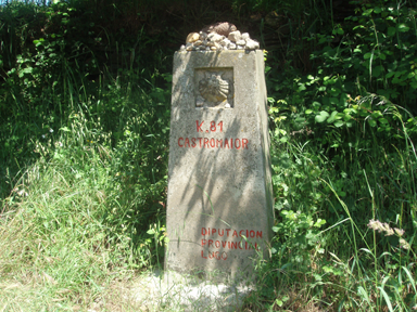
kilometric cairn - milestone (mojón kilométrico)
is there any way to tag them?. at the Camino many times is hard to know were you are, but in Galicia there are kilometric cairns every 500 mt., they are not too precise but there are very good reference points. eg "im at 35,5 km. please pick me up".--Sergionaranja 09:09, 27 June 2010 (UTC)
- Something like man_made=cairn (see Proposed features/Cairn) --FrViPofm 13:50, 27 June 2010 (UTC)
- I have found milestone as a better translation. i will add them as single nodes outside the way, but into the main relation (they are not way member milestones but relation milestones). and tag them as next eg.:
- highway=milestone
- name=K. 81 Castromaior
- if a better tagging system is approved. then, they can be modified--Sergionaranja 22:12, 27 June 2010 (UTC)
- Nice !
- Maybe with a ref=K. 81 if it makes sense. --FrViPofm 12:47, 28 June 2010 (UTC)
- well, ref tag makes sense, but for me just to name the way reference. in our case it can be ref=E3. but that is already named at the relation. the kilometer was said to be pk=81 but that was the main problem for the agreement in proposed features, some people did not understand pk as kilometer point. and some milestones talk about what is left or distance to next crossing (im talking milestones in general)... in the Camino Francés milestones mark distance to Santiago but Camino de Fisterra they mark distance to Fisterra from Santiago. so i think name=whateveriswritten is more neutral for now. if some render coder is so kind to make this show up, great. then they will be useful --Sergionaranja 14:57, 28 June 2010 (UTC)
- This is probably a new subset of information http://wiki.openstreetmap.org/wiki/Proposed_features/information guidepost and milestone are not that far away, at least in the meaning of a (historic) land marker and not the regular plastic signs you can see along the roads. There are more that style: http://wiki.openstreetmap.org/wiki/Tag:pipeline%3Dmarker even if it's along the road. several other variants e.g. Distance marker and milestone have been abandoned (http://wiki.openstreetmap.org/wiki/Abandoned_features), I am sorry. --Ottokar55 15:10, 28 June 2010 (UTC)
- i dont mind the tags. i have the info and it should not be lost. information=guidepost sounds fine enough, plus it will be rendered, i think it should go into the relation anyway. what do you think? --Sergionaranja 16:04, 28 June 2010 (UTC)
- With your precisions it seems that tourism=information + information=milestone + remaining_dist=NN would effectively be better as those milestones are specifics to the Camino. I'm not shure they must be in the relation but if you include them, think to add a role like "milestone". They are note guideposts as they are not on crosses and you are free to create a new tag. --FrViPofm 20:49, 28 June 2010 (UTC)
- ill vote on favor of your proposal when is made. ill tag them information=guidepost until then. --Sergionaranja 15:19, 6 July 2010 (UTC)
- With your precisions it seems that tourism=information + information=milestone + remaining_dist=NN would effectively be better as those milestones are specifics to the Camino. I'm not shure they must be in the relation but if you include them, think to add a role like "milestone". They are note guideposts as they are not on crosses and you are free to create a new tag. --FrViPofm 20:49, 28 June 2010 (UTC)
- i dont mind the tags. i have the info and it should not be lost. information=guidepost sounds fine enough, plus it will be rendered, i think it should go into the relation anyway. what do you think? --Sergionaranja 16:04, 28 June 2010 (UTC)

Path+Unclassified tags?
[[Image:CS_portom_palasde_sign.png|200px]] (removed for copyright reasons)
highway=unclassified + path:right=lane ? as in Bicycle --Sergionaranja 11:45, 7 July 2010 (UTC)
It's a separated track (camino), not a lane (carril)! A lane wouldn't be separated by a kerb, only by paint (white lines) on the same road. --Ottokar55 13:05, 21 July 2010 (UTC)
- This really looks more line a pavement. I would use tags for pavements for this. --Jakubt (talk) 19:07, 9 March 2019 (UTC)
Adding other parts of way in Europe
As this is very old page I am intend to boldly continue with adding other European parts of "Camino de Santiago" to the relation. After all the relation should contain all these ways. Please let me know if this is not desirable. --Gorn (talk) 01:53, 10 March 2019 (UTC)
Primary, secondary, tertiary???
I am confused about the roles for main relation. If anyone can write anything about this it can be helpful. I can imagine that the primary ways are the most known ways in Spain, but what rank are for example German or French ways. Always tertiary? For now I will leave them without role in the relation. --Gorn (talk) 02:13, 10 March 2019 (UTC)