WikiProject Haiti/Street names
- WikiProject revisions: Revisions to front page of WikiProject completed = everything consolidated into a single table or moved to different pages. --Ceyockey 16:34, 30 October 2011 (UTC)
- WikiProject revisions: Revisions are underway (slowly) to revise the WikiProject from crisis-response to mapping-as-usual mode. --Ceyockey 16:34, 30 October 2011 (UTC)
- On-the-ground: Fourth deploy write-up - 2010-09-08
- On-the-ground: HOT Mission 3 complete [1] - 2010-06-28
- Hot website launched with blog category 'Haiti' - 2010-05-??
Naming Port-au-Prince streets with US Defence topo maps
Currently one of the weaker points of OSM's Port-au-Prince coverage is street names. These can be derived from a public domain US military topo map from 1994. Potlatch now has this available as a background layer.
Setting up
- Open Potlatch for an area in Port-au-Prince, and start editing
- Open the Options window (bottom left), and choose ‘Haiti: street names’
- Then check ‘Highlight unnamed roads’, and close the Options window
- Hold Space and drag the imagery to align it with the roads
Naming roads
- Unnamed roads will have a bright red border
- Select a road and press ‘N’ to edit its name (or use tag controls as usual)
- When you’re not editing a name, press Caps Lock to dim the nodes/ways so you can read the background map
Resources
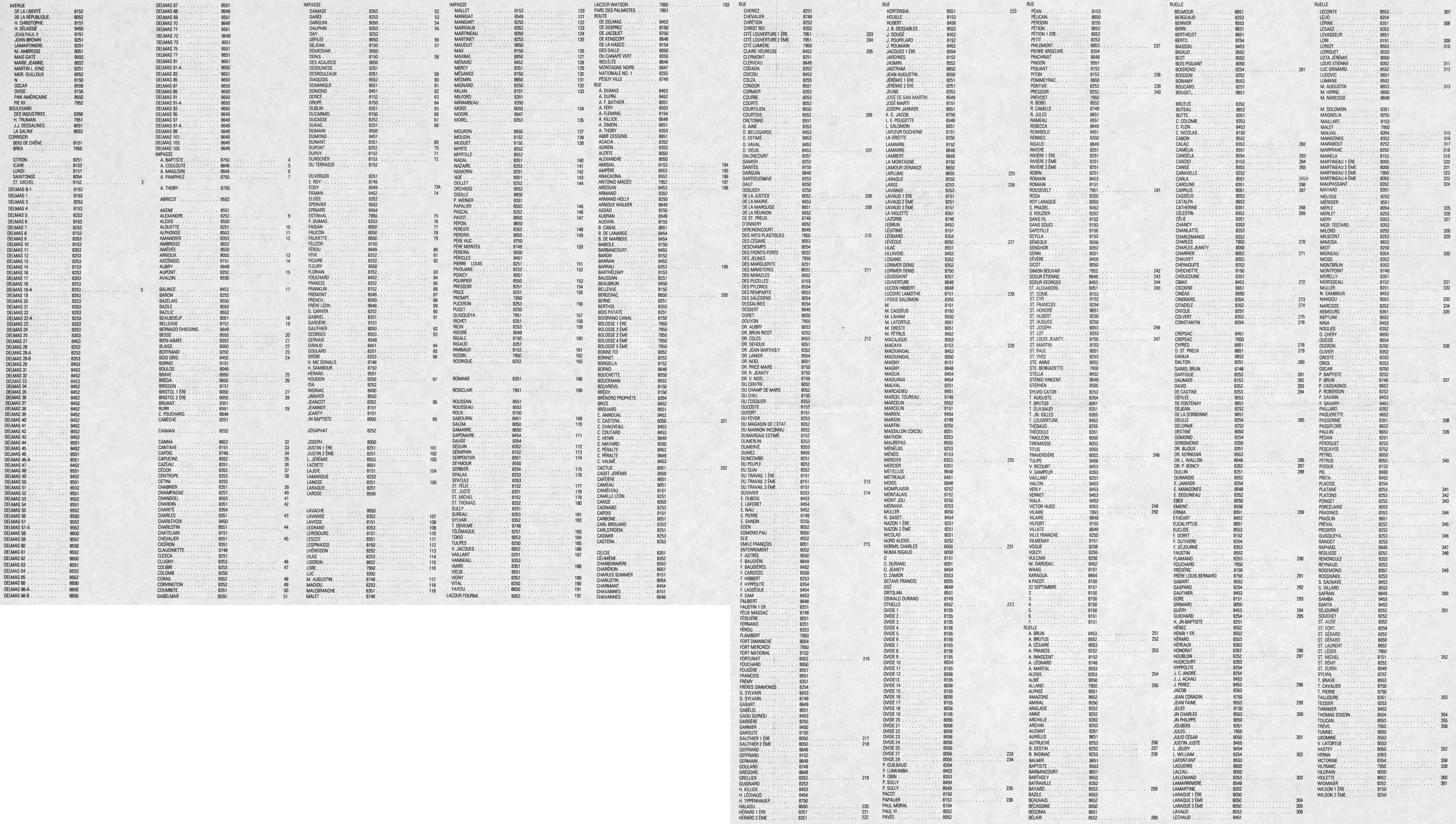
The legend from the US military map is particularly useful for numbered streets, which are labelled as (for example) 228 on the map itself when there wasn't enough space to write the full name. The name can be found by referring to the street index.
- Street index: https://richard.dev.openstreetmap.org/haiti/gazetteer_bw.jpg (900k) digitised below
- List of features: https://richard.dev.openstreetmap.org/haiti/features.jpg
- Key: https://richard.dev.openstreetmap.org/haiti/key.jpg
- Translations: https://richard.dev.openstreetmap.org/haiti/abbreviations.jpg
Street index digitised
Kam managed by running the above street index image through automated OCR to yield a complete sortbale digitised list which you can search (ctrl+F). A complete copy of the full list is available here : WikiProject_Haiti/Street_names/All Streets. The list below is of those street names which either do not exist on OSM, or have not had their existence checked.
As the numbers of missing streets fall, they become harder to find. It is easiest to scan a given MGRS grid square, using the imagery at haiticrisismap.org. In many cases streets not found using the Nominatim queries in the table may already be named, but may lack the first element of the name, or have minor differences in spelling, or the name may have been expanded. Also some missing names have occurred because of the difficulty of reading the numbers on the DMA maps, so a name has been entered in two places. Always check the grid square where you are making the change. If you try and resolve a name but are unable to find the street, please make a note in the table: it will save others from doing the same. Then a simple 'NO' in the table means not found with Nominatim, whereas a 'NO' with a note indicates an attempt has been made to find the name by a person.
Ensure you add source:name=Haiti DMA Topo, preferably including the year (1994), too. The MINUSTAH GIS 2007 map is also being used for street names, and in some cases there is conflict. It makes life difficult for other mappers if they cannot verify your data against your sources, and requires time-consuming email exchanges to establish sources.
Many names lack accents and could be improved, the link to the diff report quickly identifies likely candidates.
| Date | No. Unchecked/unmapped |
|---|---|
| 2010-01-24 | 569 |
| 2010-01-25 | 387 |
| 2010-01-26 | 266 |
| 2010-01-27 | 224 |
| 2010-01-28 | 121 |
| 2010-01-29 | 80 |
| 2010-01-30 | 72 |
| 2010-01-31 | 35 |
| 2010-02-01 | 57 |
| 2010-02-02 | 38 |
| 2010-02-03 | 22 |
A quite simple diff report: http://yellowcabcar.de/osm_haiti/str_diff_pap.htm
Note that the name=* tag should be input in Lower Case But With Capitalised First Letters into our map data. You may also want to check the accents were OCR'd correctly (â = Accent circonflex, á = Accent aigu, à = Accent grave)
Map features digitised
Following Richard's lead, I am adding the map features. People are asking for hospitals and other POI's, so I thought this might be useful. I have started with the medical section since that is a priority. Keep in mind this data comes from that military topographic map from 1994, so the validity of the data is questionable. More to come . . .
| Type | Name | x | y | GridSq | GridCentre | No. | On OSM |
|---|---|---|---|---|---|---|---|
| Asylum | Asile Communal | 80 | 53 | 8053 | 81 | ||
| Asylum | Asile Francais | 80 | 51 | 8051 | 82 | ||
| Medical Center | Centre de Santé de la Cathédral | 80 | 52 | 8052 | 83 | ||
| Medical Center | Centre de Santé du Portail Léogane | 79 | 51 | 7951 | 84 | ||
| Medical Center | Centre de Santé Eliazer Germain (P-V) | 86 | 49 | 8649 | 85 | ||
| Medical Center | Centre d'Hygiene de la Saline | 80 | 54 | 8054 | 86 | ||
| Medical Center | Centre Médico Social Céleste Casimir | 80 | 51 | 8051 | 87 | ||
| Haitian Red Cross | Croix Rouge Hatienne | 79 | 52 | 7952 | 88 | ||
| Hospital | Grâce Children's Hospital | 84 | 54 | 8454 | 89 | ||
| Hospital | Hôpital Adventist | 75 | 50 | 7550 | 90 | ||
| Hospital | Hôpital de l'Université d'Etat d'Haiti | 80 | 51 | 8051 | 91 | ||
| Hospital | Hôpital du Canapé Vert | 83 | 51 | 8351 | 92 | ||
| Hospital | Hôpital IDASH | 82 | 54 | 8254 | 93 | ||
| Military Hospital | Hôpital Militaire | 80 | 51 | 8051 | 94 | ||
| Military Hospital | Hôpital François de Sales | 80 | 51 | 8051 | 95 | ||
| Radiological Lab | Laboratoire Radiologique | 80 | 51 | 8051 | 96 | ||
| Maternity Ward | Maternité Isaie Jeanty | 81 | 54 | 8154 | 97 | ||
| Tuberculosis Sanatorium | Sanatorium Antituberculeux | 80 | 50 | 8050 | 98 |
Naming streets in other cities using MINUSTA city maps
Maps of other cities, produced by the United Nations Stabilization Mission in Haiti (MINUSTAH GIS), are available to add street names for other areas. ftp://haiti:Rkjpb7uef@157.150.195.135/Maps/City%20maps/
(Names from these maps for Jacmel and Gonaives are done. File U4KCITI0610STM00R_50x36.pdf doesn't have street- or featurenames. --Colin Marquardt 20:35, 20 January 2010 (UTC))
(Names from these maps for Petit-Goave are done. --AndyGates)
(Names from these maps for Grand-Goâve are done. Xapitoun 14:39, 14 February 2010 (UTC)
"MINUSTAH GIS and UN Cartographic Section" must be cited as the data source. Example: source=MINUSTAH GIS and UN Cartographic Section
USGS map areas with street names
A series of maps was produced by Delta State University in coordination with the USGS and others.[1] As the notes on the maps say, the streets data on these maps is from OpenStreetMap. There is no need to compare the streets data on these maps with that in OSM!
Another proposal for a street gazeteer
[2]The project aims at developing a web application to generate a Gazetteer of street names based on OSM data overlaid by Search and Rescue (SAR) sectors and some grid reference used by the Mississipi States University in its MGRS Atlases series of Haiti using OSM as road layer (see [2]). It would produce both web-based and stand alone table from which street name can be sorted and retrieved by SAR sectors or MGRS griding elements.
Based on field knowledge rough geographic extent would be: "From Cabaret in the north, to Jacmel in the south and Conguave in the west, to Dominican Republic in the east"".Such a tool has been deemed a top priority by GIS responders on the Ground and is meant for all field responders.
Notes
- ↑ Original link is no longer active. Casual inspection of new link (inline) suggests that the new link contains the information described. Original: link
- ↑ Originally appeared on page WikiProject Haiti/StreetName Gazeteer, which now redirects to this section. See the history of the redirect for more information.