2023 Morocco Earthquake
| General Information | |||||||||||||||||||
MOROCCO EARTHQUAKE RESPONSE SEPTEMBER 2023 The 2023 Moroccan earthquake struck several Moroccan cities on the night of September 08 to 09, 2023 at 23:11 (local time). With a magnitude of 6.8 and a deep focus of 18.5 kilometers, according to the USGS, the quake was followed by an aftershock of 4.9 magnitude 19 minutes later. The epicenter of the initial quake is located in the High Atlas Mountains, 71 km southwest of Marrakech. The death toll from the earthquake that shook several towns in the Kingdom of Morocco has risen to 2012, according to a new provisional report released by the Moroccan authorities on Saturday evening. The Moroccan Ministry of the Interior said in a statement that "in an updated toll, the number of dead has reached 2497 victims, while 2476 people were injured, including 1404 in serious condition.". To get to the latest mapping projects for the Morocco earthquake response, please use this URL: https://tasks.hotosm.org/explore?campaign=Morocco%20Earthquake%202023 (it will always take you to the current and live projects on the tasking manager). To see the combined extents of the Tasking Manager projects, view this web map. | |||||||||||||||||||
For Aid Organizations
Map and Data Services
Exporting OpenStreetMap data
Via OpenStreetMap: See Downloading data for instructions on getting large scale map data, or see the focused exports below:
Via HDX: Regularly updated OpenStreetMap exports are available on Humanitarian Data eXchange (HDX): OSM layers for Morocco are updated every six hours
Via overpass: This query provides data representing destroyed or inaccessible roads https://overpass-turbo.eu/s/1AwV
Using OSM data on mobile
The team behind OSMAnd has also made maps of Morocco and Libya freely downloadable to support teams in the field.
Mapping with Post Earthquake Imagery
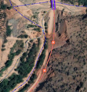
On 14 September a special Tasking Manager project was published which focuses on updating OSM roads using post earthquake imagery from Maxar (captured 10 and 11 September 2023). Where there is obvious damage to roads contributors are asked to add the following tags (being selective where relevant) to a node on a road where there is evident damage or blockage:
barrier=debris
access=no
damage:type=earthquake
damage:date=2023-09-08
damage:event=2023 Morocco earthquake
fixme=resurvey after recovery
See:
Contributors are asked to check all roads (highways) that are passable by four-wheeled-vehicle (primary, secondary, tertiary, unclassified, residential) looking for visible damage or blockages in the post-quake imagery.
Contributors are also asked to map any new bypass routes being used, if there are clearly new access routes being used to bypass road blockages.
Due to its complexity this project type is restricted to only the most experienced contributors on Tasking Manager (specifically these Tasking Manager teams: HOT Global Validators, MSF Validators, Data Quality Interns). The imagery can be seen by loading a task in the project or by visting OpenAerialMap.
See this Overpass query to vizualise the mapped 'access=no' points (and select 'Export' to download): https://overpass-turbo.eu/s/1AwZ
About This Disaster Activation
About HOT

To learn more about the Humanitarian OpenStreetMap Team (HOT), explore more of our wiki-pages (root: HOT) or our website hotosm.org. HOT is a global community, mostly of volunteers, and it is a US registered nonprofit able to contract with organizations (email info at hotosm.org to contact our staff), we are also a 501(c)(3) charitable organization.
History of this Activation
Reactivity of the OSM Community
09 Sept, 2023 - Following the event, staff from HOT's West and Northern Africa Open Mapping Hub and OSM Morocco agreed to launch an activation to support response efforts.
Coordination
- Lead(s):
- Marie Makuate (HOT Activation Lead)
- Fatima Eddaoudi (Tasking Manager project Manager)
Data Quality
All contributions through HOT's Tasking Manager are tracked with a unique changeset comment tag: #moroccoearthquake2023.
Validation
Validation permissions for Tasking Manager projects are restricted to particular Tasking Manager Teams / users to ensure high quality validation:
OSMCha - A specific OSMCha filter can be used to detect data quality issues across a wider area.
For Mappers
- HOT Coordinator(s) requesting remote mapping assistance
How You Can Contribute
Go to the latest mapping projects
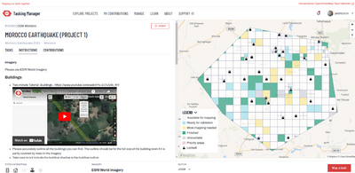
You can find the latest mapping projects on the HOT Tasking Manager at https://tasks.hotosm.org/explore?campaign=Morocco%20Earthquake%202023
Learn to Map
- Most of our volunteer needs are for remote OSM contributors, visit LearnOSM.org to get started.*
Mapping Tips and Advice for this Activation
Read the Instructions!
- Every project includes instructions on the left-hand side of the page for selecting tasks to maps. Take the time to read these instructions. The time you spend reading them will be saved in more efficient validation down the line.
Task Selection
- The last few tasks in a project are often the most difficult. If they seem above your level, consider moving to a new project.
- Alternatively, if you are an advanced mapper, consider tackling the last few tasks to help complete the project.
- The area is quite mountainous and may be easy to miss smaller settlements when mapping. Please take extra care to thoroughly review the area in the task before marking as complete.
Building and Road Basics
- Martien van de Griendt has two tutorials that are useful refreshers in mapping roads and buildings.
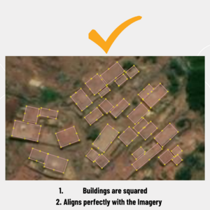
- Missing Maps also offers a number of tutorials and trainings for improving your mapping.
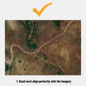
- When mapping, ensure that roads align with the Imagery specified in the project, in this case ESRI Imagery.
Tagging Roads
- If you are unsure of what tag to use for roads in an area, you can ask in the #disaster-mapping channel on the HOTOSM Slack (also accessible via Matrix as #openmapping-humanitarian-activation-wg:matrix.org) or in the Questions and Comments section of the project.
- The simplest way to tag roads is as residential if they are in a town and unclassified if they are outside of a town.
- Check out this Wiki Page on tagging roads in Morocco.
Carrying Roads Over into Adjacent Tasks
- When you are mapping, please connect your roads to where they are mapped in the adjacent task. When you are validating a task please check the the roads are carrying through to the next task and also that the status is continued into the adjoining tasks.
Tall Buildings
- Many of the dense areas in this activation include tall buildings. Please watch this tutorial by Blake Girardot on mapping tall buildings in urban areas.
Keeping Adjacent Buildings Separate
- Freestanding buildings shouldn't share nodes with their neighbours. When it has happened accidentally, you can use the disconnect option ("D") to 'unglue' the nodes from each other (nodes that are shared are grey instead of white). To avoid it happening, hold down the ALT key while you are placing a node near another building - it will prevent nodes from snapping together.
Building Materials
- DO NOT USE - building:walls=brick. Consider using the more common key building:material=
- DO NOT USE - building:roof=tin. This key has been labeled as deprecated. The recommended replacement is: roof:material=*
Use of the Issues Tool, Finding Unsquared Corners
- Using the Issues tool on the right-hand side of the screen helps you to check your own and other mappers’ work before exiting the task. In the iD Editor, click the issues icon or type ‘i’ to open the menu. To find all unsquared buildings, change the value of "Unsquare Corners" to “up to 20°”.
Other Mapping tips useful for this activation (Feedback from Validators)
- Do not connect nodes of buildings to each other and avoid mapping clustered building. Each building should be mapped individual.
- Please avoid mapping several buildings as one building. Every building must be traced separately. Zoom in as close as possible to see the outline of the buildings, hit each corner of the building carefully. Look for shadows, open ground, changes in roof color.
- Please don't cluster buildings. Also do not include the courtyards in your mappings.
- The tag 'road' is too general, Use unclassified when roads connect settlements.
- In the province of El Haouz, in rural areas, houses are built of earth, next to each other, which sometimes makes it difficult to separate buildings from their surroundings, especially if there are trees nearby. I propose to map the building according to its external contour, independently of its internal shape.
Please see this page for additional tips
Mapping Tasks & Priority
Please use Humanitarian OpenStreetMap Team's Tasking Manager to look for and map projects. Please choose from highest priority first.
| Project number | Project name | Priority | Location | What to map | Imagery Source | Project Mapping Status | Project Validation Status |
|---|---|---|---|---|---|---|---|
| 15468 | MOROCCO EARTHQUAKE (PROJECT 1) | Archived | Morocco | Roads, Buildings | ESRI World | 100% Complete | 100% Complete |
| 15475 | EARTHQUAKE IN MOROCCO (PROJECT 2) | Archived | Morocco | Roads, Buildings | ESRI World | 100% Complete | 100% Complete |
| 15476 | EARTHQUAKE IN MOROCCO (PROJECT 3) | Archived | Morocco | Roads, Buildings | ESRI World | 94% | 79% |
| 15477 | EARTHQUAKE IN MOROCCO (PROJECT 4) | Archived | Morocco | Roads, Buildings | ESRI World | 100% Complete | 100% Complete |
| 15478 | EARTHQUAKE IN MOROCCO (PROJECT 5) | Archived | Morocco | Roads, Buildings | ESRI World | 100% Complete | 100% Complete |
| 15504 | Morocco: Mapping Damaged Roads using Post Earthquake Imagery | Archived | Morocco | Road blockages | Maxar from OpenAerialMap | 100% Complete | 100% Complete |
Available Imagery
Shortly after the earthquake Maxar released pre and post earthquake imagery through its Open Data Program.
This imagery was uploaded to OpenAerialMap for public access and ease for linking to Tasking Manager.
Community Mapathons
| Date | Time | Lead Community | Country | Location/ Meeting Link/ Registration Link | Type | Status | Notes | Social Media Post |
|---|---|---|---|---|---|---|---|---|
| 2023-09-09 | ? | OSM Rwanda | Rwanda | In-person | DONE | |||
| 2023-09-12 | 17:00 PST | UP Resilience Institute YouthMappers | Philippines | https://twitter.com/UPRIYouth/status/1701150898402341148?s=20 | In-person | DONE | https://twitter.com/UPRIYouth/status/1701150898402341148?s=20https://x.com/UPRIYouth/status/1701593522749776336?s=20 | |
| 2023-09-26 | 17:00 CEST | IHE Delft | Netherlands | https://www.un-ihe.org/iheurgentaction-mapathon-morocco-and-libya | In-person and remote | DONE | https://twitter.com/hansakwast/status/1706771136279711820 | |
| 2023-09-20 | 13:00 WAT | OSM Niger | Niger | https://x.com/OSMNiger/status/1704114528470929572?s=20 | In-person and remote | Done | https://x.com/OSMNiger/status/1704114528470929572?s=20 |
See also
- 2023 Marrakesh-Safi earthquake (English)
