File:DOP Lauf Kreuzung.jpg
Jump to navigation
Jump to search


Size of this preview: 750 × 600 pixels. Other resolutions: 300 × 240 pixels | 600 × 480 pixels | 960 × 768 pixels | 1,280 × 1,024 pixels.
Original file (1,280 × 1,024 pixels, file size: 848 KB, MIME type: image/jpeg)
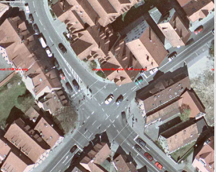
Luftbild mit 15 cm Auflösung, Screenshot aus JOSM
Die Luftbilder dürfen zum Abdigitalisieren für Openstreetmap verwendet werden. Eine weitergehende Verwendung ist nicht erlaubt.
This is a Featured image, which means that it has been identified as one of the best examples of OpenStreetMap mapping, or that it provides a useful illustration of the OpenStreetMap project. If you know another image of similar quality, you can nominate it on Featured image proposals.
Front-page image for week 1 of 2010 (4–10 Jan.).
- Image descriptions
- čeština : Ortofotomapa Laufu v Německu (mapa) s rozlišením 15 cm a přesností pozice 0,5 metru. Tato mapa byla darována místní městskou samosprávou. Vizte DE:Luftbilder aus Lauf.
- Deutsch : Luftbilder in 15 cm Auflösung, 0,5 m Positionsgenauigkeit, gespendet von der Stadt Lauf, Deutschland. Siehe das Projekt und Karte
- English : 15 cm high res aerial imagery with 0.5 m positional accuracy, of Lauf in Germany (map) donated by the local municipality. See DE:Luftbilder aus Lauf.
- español : Imágenes aéreas con 15 cm de alta resolución y 0.5 m de precisión posicional de Lauf en Alemania (map) donadas por el gobierno local. Vea DE:Luftbilder aus Lauf (en alemán).
- français : Une orthophoto numérique, avec une résolution de 15 cm et une précision de position de 0,5 m, donnée par la commune de Lauf en Allemagne pour améliorer OSM.
- italiano : Foto aeree con diluizione di precisione (DOP) in alta risoluzione di 15 cm, accuratezza della posizione pari a 0.5 m, donate dal comune di Lauf, in |Germania, per migliorare le mappe di OSM. Vedi il progetto e la mappa.
- latviešu : Vācijas pilsētas Lauf pašvaldības dāvināti 15 cm izšķirtspējas aerofoto ar 0,5 m pozicionālu precizitāti (karte). Skat. DE:Luftbilder aus Lauf.
- magyar : A németországi Lauf (térkép) 15 cm-es nagy felbontású légifotóját 0,5 m-es pozicionálási pontossággal adományozta a helyi önkormányzat. Lásd de:Luftbilder aus Lauf.
- polski : Rozdzielczość 15 centymetrów na piksel, dokładność do pół metra, takie zdjęcia udostępniły władze miasta Lauf an der Pegnitz w celu lepszego pokrycia miasta w OSM. Więcej informacji na stronie projektu (niem.), mapa.
- português : Ortofoto com 15 cm de resolução et com uma posição de 0.5 m de precisão, oferecida pela municipalidade de Lauf na Alemanha para melhorar o projecto OSM. Veja o projecto e o mapa.
- suomi : Lauf (kartta), kunta Saksassa, on antanut OSM:in käyttöön alueensa tarkat ilmakuvat 15cm erottelukyvyllä. Lisätietoa saksaksi.
- русский : Снимки высокого разрешения (15 см DOP) с точностью позиционирования 0,5 м, спонсируемые муниципалитетом для повышения качества OSM. Подробности: проект (Германия) и карта.
File history
Click on a date/time to view the file as it appeared at that time.
| Date/Time | Thumbnail | Dimensions | User | Comment | |
|---|---|---|---|---|---|
| current | 08:11, 30 November 2009 | | 1,280 × 1,024 (848 KB) | Markus B (talk | contribs) | Luftbild mit 15 cm Auflösung, Screenshot aus JOSM |
You cannot overwrite this file.
File usage
The following 13 pages use this file:
- Community Updates/2010-10-04
- Featured images/Jan-Mar 2010
- List of featured images/2010
- Pl:Cyfrowa ortofotomapa
- Project of the week/2010/Oct 06
- Template:Iotw image/2010-1
- DE:Digitale Orthophoto
- DE:Featured images/Jan-Mar 2010
- DE:Luftbilder aus Lauf
- DE:Mapping techniques
- DE:Project of the week/2010/Oct 06
- FR:Featured images/Jan-Mar 2010
- IT:Featured images/Jan-Mar 2010