File:Josm spain geodesy network.png
Jump to navigation
Jump to search


Size of this preview: 766 × 600 pixels. Other resolutions: 307 × 240 pixels | 613 × 480 pixels | 981 × 768 pixels | 1,252 × 980 pixels.
Original file (1,252 × 980 pixels, file size: 149 KB, MIME type: image/png)
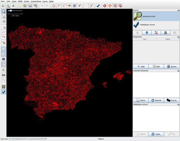
Spanish OSMers got permission to import government data into OSM.
The first task has been importing the "ROI" geodesy network; supposedly this is the first time that data from a National Mapping Agency is imported directly into OSM. "ROI" stands for "Red de Orden Inferior", or "Lesser Order Network".
Map of Spain
This map and others like it, were created by OpenStreetmap contributors, and are licensed as Creative Commons CC-BY-SA 2.0 (https://creativecommons.org/licenses/by-sa/2.0/) (see OpenStreetMap licence).
Use {{mapof|PlaceName}} to add this template to your images.
This map and others like it, were created by OpenStreetmap contributors, and are licensed as Creative Commons CC-BY-SA 2.0 (https://creativecommons.org/licenses/by-sa/2.0/) (see OpenStreetMap licence).
Use {{mapof|PlaceName}} to add this template to your images.
This is a Featured image, which means that it has been identified as one of the best examples of OpenStreetMap mapping, or that it provides a useful illustration of the OpenStreetMap project. If you know another image of similar quality, you can nominate it on Featured image proposals.
Front-page image on 14 Jul 2007
![]()
This file is a JOSM screenshot, without imagery in a background.
![]()
"JOSM" (Java OpenStreetMap Editor – josm.openstreetmap.de) is free software released under the terms of the GNU General Public License as published by the Free Software Foundation; either version 2 of the license, or any later version.
It may include old OpenStreetMap data (before September 12, 2012), in such case CC-BY-SA-2.0 also applies:
![]()
Contains map data © OpenStreetMap contributors, made available under the terms of the Creative Commons Attribution-ShareAlike 2.0 (CC-BY-SA-2.0).
File history
Click on a date/time to view the file as it appeared at that time.
| Date/Time | Thumbnail | Dimensions | User | Comment | |
|---|---|---|---|---|---|
| current | 15:09, 12 July 2007 | | 1,252 × 980 (149 KB) | Ivansanchez (talk | contribs) |
You cannot overwrite this file.
File usage
The following 4 pages use this file: