File:Marburg blind mapping.jpg
Jump to navigation
Jump to search


No higher resolution available.
Marburg_blind_mapping.jpg (640 × 427 pixels, file size: 96 KB, MIME type: image/jpeg)
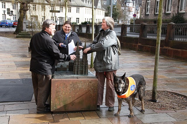
Mapping Party Marburg, Germany, 28.2.2010. Blind and seeing mappers discover a tactile model of the Elisabethkirche.
This is a Featured image, which means that it has been identified as one of the best examples of OpenStreetMap mapping, or that it provides a useful illustration of the OpenStreetMap project. If you know another image of similar quality, you can nominate it on Featured image proposals.
Front-page image for week 40 of 2010 (4–10 Oct.).
- Image descriptions
- Deutsch : Mapping Party in Marburg: Blinde und sehende Mapper entdecken ein haptisches Modell der Elisabethkirche mit barrierefreien GPS-Geräten.
- English : Mapping Party in Marburg, Germany: Blind and seeing mappers discover a tactile model of Elisabethkirche with accessible GPS devices.
- français : Mapping Party à Marbourg, Allemagne : cartographes non-voyants et voyants découvrent un modèle tactile de l'Elisabethkirche avec un système de GPS accessible.
- italiano : Mapping Party a Marburgo, Germania: i mappatori non vedenti e vedenti hanno scoperto un modello tattile della chiesa di Santa Elisabetta con dei dispositivi GPS accessibili.
- lietuvių : Mapping susitikimas mieste Marburg, Vokietijoje: Akli ir matantys atranda apčiuopimą Šv. Elizabietos bažnyčios modelį, naudojant specialius GPS prietaisus.
- polski : Mapping Party w Marburgu w Niemczech: Niewidomi i widzący mapowicze odnajdują dotykowy model Kościoła świętej Elżbiety za pomocą specjalnie dostosowanego odbiornika GPS.
- português : Depois de muitos anos de trabalho pesado, o Wiki do OSM ainda renderiza, de forma brilhante, os links inexistentes em cor vermelha. Aqui vemos um, apontando para uma entrada atrasada de Propostas de Imagem.
- русский : Картовстреча в Марбурге, Германия: слепые и зрячие картографы нашли тактильную модель церкви Святой Елизаветы с помощью специальных GPS-навигаторов.
- 中文(繁體) : 在德國馬堡舉行的Mapping party: 視障和眼明人一起利用GPS裝置發現Elisabethkirche的模型。
File history
Click on a date/time to view the file as it appeared at that time.
| Date/Time | Thumbnail | Dimensions | User | Comment | |
|---|---|---|---|---|---|
| current | 13:37, 8 March 2010 | | 640 × 427 (96 KB) | Lulu-Ann (talk | contribs) | Mapping Party Marburg, Germany, 28.2.2010. Blind and seeing mappers discover a tactile model of the Elisabethkirche. |
You cannot overwrite this file.
File usage
The following 8 pages use this file: