File:Railway-station-tagging simple.svg
Jump to navigation
Jump to search


Size of this PNG preview of this SVG file: 512 × 200 pixels. Other resolutions: 320 × 125 pixels | 640 × 250 pixels | 1,024 × 400 pixels | 1,280 × 500 pixels.
Original file (SVG file, nominally 512 × 200 pixels, file size: 391 KB)
Summary
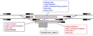
| Description | Simple tagging of a railway station. Red: public_transport=*; pink: railway=*; blue: route=train scheme. |
|---|---|
| Author | Nakaner, Dieterdreist, Gymate |
| Source | Railway-station-tagging.svg with some objects hidden. If you wish to make edits, please edit and update that file first, then hide the necessary objects, export the illustration and update this file! |
| Date | 2024-01-14 |
| Other versions | Railway-station-tagging.svg |
Licensing
![]()
![]()
![]()
This work is licensed under the Creative Commons Attribution-ShareAlike 4.0 License.
Attribution: Nakaner, Dieterdreist, Gymate
Attribution: Nakaner, Dieterdreist, Gymate
File history
Click on a date/time to view the file as it appeared at that time.
| Date/Time | Thumbnail | Dimensions | User | Comment | |
|---|---|---|---|---|---|
| current | 13:21, 26 March 2024 | 512 × 200 (391 KB) | Gymate (talk | contribs) | Converted texts to outlines due to librsvg rendering them incorrectly (?) – use the previous version if you want to make edits | |
| 13:21, 26 March 2024 | 512 × 200 (27 KB) | Gymate (talk | contribs) | Added missing train=yes tags | ||
| 21:51, 14 January 2024 | 512 × 191 (457 KB) | Gymate (talk | contribs) | Converted text to outlines due to librsvg rendering them incorrectly (?) – use the previous version if you want to make edits {{CC-BY-SA-4.0-self}} | ||
| 21:40, 14 January 2024 | 512 × 191 (31 KB) | Gymate (talk | contribs) | {{Information | description=Simple tagging of a railway station. Red: {{Key|public_transport}}; pink: {{Key|railway}}; blue: {{Tag|route|train}} scheme. | source= | date=2024-01-14 | author=Gymate | other_versions=File:Railway-station-tagging.svg }} |
You cannot overwrite this file.
File usage
The following page uses this file: