File:Row houses Salaspils.png
Jump to navigation
Jump to search


Size of this preview: 800 × 411 pixels. Other resolutions: 320 × 164 pixels | 640 × 329 pixels | 1,040 × 534 pixels.
Original file (1,040 × 534 pixels, file size: 52 KB, MIME type: image/png)
Summary
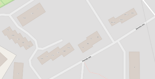
| Description | Row houses in Salaspils, Latvia digitized as one building instead of multiple ones. |
|---|---|
| Author | Dāvis Kļaviņš |
| Source | OSM |
| Date | 11.12.2022 |
Licensing
![]()
![]()
This screenshot contains OpenStreetMap Carto rendering.
The OpenStreetMap Carto map style is made available under the Creative Commons CC-0 1.0 Universal Public Domain Dedication.
- Attribution to the map data:
| Contains map data © OpenStreetMap contributors, made available under the terms of the Open Database License (ODbL).
The ODbL does not require any particular license for maps produced from ODbL data, produced maps may be subject also to other licences. |
File history
Click on a date/time to view the file as it appeared at that time.
| Date/Time | Thumbnail | Dimensions | User | Comment | |
|---|---|---|---|---|---|
| current | 14:23, 11 December 2022 | | 1,040 × 534 (52 KB) | Latvia-bot (talk | contribs) | {{Information | description=Row houses in Salaspils, Latvia digitized as one building instead of multiple ones. | source=OSM | date=11.12.2022 | author=Dāvis Kļaviņš }} |
You cannot overwrite this file.
File usage
The following page uses this file: