File:Torii-Tower 7810.jpg
Jump to navigation
Jump to search


Size of this preview: 399 × 599 pixels. Other resolutions: 160 × 240 pixels | 320 × 480 pixels | 512 × 768 pixels | 682 × 1,024 pixels | 1,365 × 2,048 pixels.
Original file (1,365 × 2,048 pixels, file size: 1.72 MB, MIME type: image/jpeg)
This file and its description are from Wikimedia Commons.
Summary
| Description |
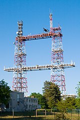
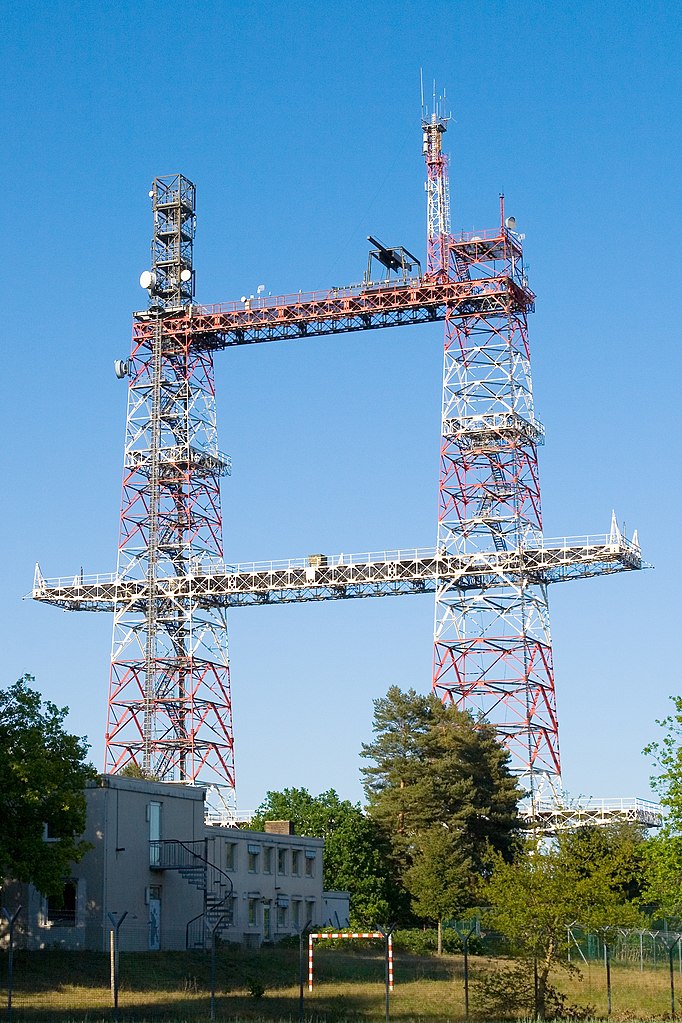
Deutsch: Torii-Tower bei Gusborn im Landkreis Lüchow-Dannenberg, Niedersachsen. Der Torii-Tower ist ein 1972 errichteter 97 Meter hoher als Doppelturm ausgeführter Stahlfachwerkturm. Die Bauweise erinnert an ein Torii genanntes Tor in japanischen Tempeln.
English: Torii-Tower near Gusborn in the district Luechow-Dannenberg in Lower Saxony, Germany. The Torii Tower is a 1972 built 97 metres high lattice mast. The mast reminds of a Torii, a traditional Japanese gate commonly found at the entry to a Shinto shrine. |
||||||||
| Date | |||||||||
| Source | Self-photographed | ||||||||
| Author | Torsten Bätge | ||||||||
| Permission (Reusing this file) |
Deutsch: Die Nutzung außerhalb der Bedingungen der GNU-Lizenz für freie Dokumentation in der Originalfassung oder der deutschen Übersetzung von Hugo Giese jr. ist honorarpflichtig gemäß derzeit gültiger Broschüre Bildhonorare der Mittelstandsgemeinschaft Foto-Marketing (MFM-Liste). Wenn Sie das Bild unter anderen Bedingungen nutzen möchten oder es in einer anderen Auflösung benötigen, kontaktieren Sie mich bitte per E-Mail. |

| Camera location | | View this and other nearby images on: OpenStreetMap |
|---|
File history
Click on a date/time to view the file as it appeared at that time.
| Date/Time | Thumbnail | Dimensions | User | Comment | |
|---|---|---|---|---|---|
| current | 12:29, 6 May 2007 | | 1,365 × 2,048 (1.72 MB) | wikimediacommons>Torsten Bätge | == Beschreibung == Coordinates: {{coor dms|53|5|20|N|11|13|34|E|type:landmark_region:DE-NI}} {{Information |Description= {{de|'''Torii-Tower''' bei Gusborn im Landkreis Lüchow-Dannenberg, Niedersachsen. Der Torii-Tower ist ein 1972 errichteter 97 Meter |
File usage
The following 14 pages use this file:
- Key:tower:type
- Pl:Key:tower:type
- Talk:Key:tower:type
- Template:DE:Map Features:Tower:type
- Template:FR:Map Features:Tower:type
- Template:IT:Map Features:Tower:type
- Template:JA:Map Features:Tower:type
- Template:Map Features:Tower:type
- Template:Pl:Map Features:Tower:type
- DE:Key:tower:type
- FR:Key:tower:type
- IT:Key:tower:type
- RU:Key:tower:type
- JA:Key:tower:type