iLOE
| iLOE | ||||||||||||||||||||||||||||||||||||||||||||||||||||||||||||||||||||||||||||||||||||||||||||||||||||||||||||||||||||||||||||||||
|---|---|---|---|---|---|---|---|---|---|---|---|---|---|---|---|---|---|---|---|---|---|---|---|---|---|---|---|---|---|---|---|---|---|---|---|---|---|---|---|---|---|---|---|---|---|---|---|---|---|---|---|---|---|---|---|---|---|---|---|---|---|---|---|---|---|---|---|---|---|---|---|---|---|---|---|---|---|---|---|---|---|---|---|---|---|---|---|---|---|---|---|---|---|---|---|---|---|---|---|---|---|---|---|---|---|---|---|---|---|---|---|---|---|---|---|---|---|---|---|---|---|---|---|---|---|---|---|---|
| Author: | Johannes Eiseler | |||||||||||||||||||||||||||||||||||||||||||||||||||||||||||||||||||||||||||||||||||||||||||||||||||||||||||||||||||||||||||||||
| License: | Proprietary (0.99$) | |||||||||||||||||||||||||||||||||||||||||||||||||||||||||||||||||||||||||||||||||||||||||||||||||||||||||||||||||||||||||||||||
| Platform: | iPhone | |||||||||||||||||||||||||||||||||||||||||||||||||||||||||||||||||||||||||||||||||||||||||||||||||||||||||||||||||||||||||||||||
| Status: | Broken | |||||||||||||||||||||||||||||||||||||||||||||||||||||||||||||||||||||||||||||||||||||||||||||||||||||||||||||||||||||||||||||||
| Version: | 1.9.4 (2011-06-30) | |||||||||||||||||||||||||||||||||||||||||||||||||||||||||||||||||||||||||||||||||||||||||||||||||||||||||||||||||||||||||||||||
| Language: | English
| |||||||||||||||||||||||||||||||||||||||||||||||||||||||||||||||||||||||||||||||||||||||||||||||||||||||||||||||||||||||||||||||
| Website: | http://itunes.apple.com/app/iloe-openstreetmap-editor/id333224774?mt=8 | |||||||||||||||||||||||||||||||||||||||||||||||||||||||||||||||||||||||||||||||||||||||||||||||||||||||||||||||||||||||||||||||
|
iPhone editor for the advanced user | ||||||||||||||||||||||||||||||||||||||||||||||||||||||||||||||||||||||||||||||||||||||||||||||||||||||||||||||||||||||||||||||||
| ||||||||||||||||||||||||||||||||||||||||||||||||||||||||||||||||||||||||||||||||||||||||||||||||||||||||||||||||||||||||||||||||
| Unmaintained. Last update in mid-2011. |
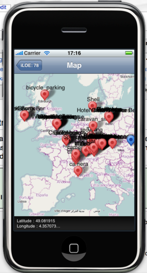
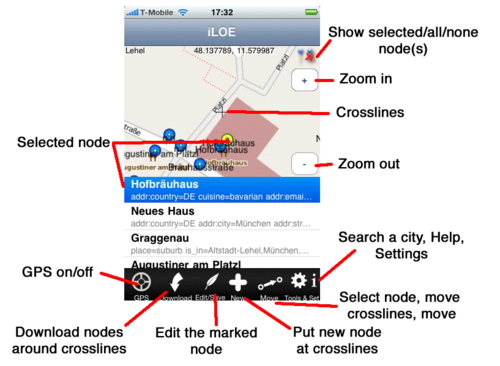
iPhone Little OpenStreetMap Editor (iLOE) is the first editor for iPhone and iPod Touch that launched on the 22nd October 2009 in the Apple App Store.
iLOE can add, update or move nodes and edit tags from ways. The application offers following functions: Localize your position. Search for any city (worldwide). Move the search target on the map. Download the nodes and ways around your or any position. Edit, delete and insert tags in a node or a way. Create or move a node. Upload the node and tags to OpenStreetMap.
Current version 1.9.4 was released June, 2011.
Instructions
If you want to upload nodes, you need a OSM user/password. In the app choose button "i", choose settings: User/password -> save.
The buttons from left to right:
- Localize: When on (red ring inside) your gps is on, searching for your position and moves the map to your position. It automatically turns off when gps found the best localization. Turn it manually off (without red ring), when you start editing. You can alwas turn on and off.
- Download Nodes: Use this button to download the existing nodes and ways around your crosspoints. Use it also after finishing uploading to see the changes you did (Why doesn't the application load the nodes automatically? A: That would be too much data).
Now, when nodes around the crosspoint, they'll be shown in the map and in the list beneath. Use the list to scroll and pick a certain node or tap a node.
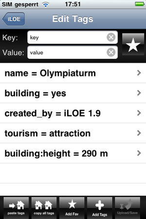
- Edit a node: Scroll the list and pick a node or tap a node on the map. Use the "Edit Node" button r the popup window. A new screen with the tags of the node will be shown. If you got the wrong node, just go back. If you don't save a node it will never be changed.
- Delete a tag: Swipe
- Alter a tag: Select it, overwrite the value, go back and save node.
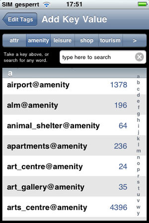
- You have 3 more choices "copy/paste tags" is for a whole set of tags (mapping every house in a street for example. With Favs you save your personal favorite tags. With the database you can search in about 2000 predefined tags.
- Upload your node/tags when finished.
- New node: Move crosslines to the position. Choose button "New". Then same procedure as "edit node".
- To move a node: Select it from list. The map will center to the node. Move till crosslines point to the new position. Button "Move". Then upload.
- Tools: Search City: (You don't need this if you just start). With gps off, you can use this to move to every city world-wide. Usefull to add information on a node you visited. "opening_hours" for example.
- Tools: New Target on Map: (You don't need this if you just start). Same as "search city", only you move/zoom the new position manually on the bigger map.
- i : Help, (c) and Settings
New
New in Version 1.5/1.6: There 2 new Buttons: "copy tags" and "paste tags". "copy tags" copies all the tags from the node. "paste tags" add the copied tags to a node. the copied tags are remembered even if you leave the application. Very usefull to tag addr:* for a whole street for example.
Features in the 1.8 version: Remembers the last position. Switch to change size of map vs. list copy/paste with 5 slots Ways: Edit tags
Features with 1.9: New searchable database with about predefined 2000 tags Personal Favorites list Retina display support
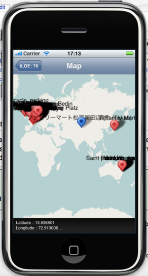
iLOE nodes (shows the nodes created with iLOE): Show in map
other iPhone OSM Editors
iLOE was/is made for the advanced OSM mapper, maybe you'll find Mapzen POI Collector easier to start if you are a beginner.
Have a look at iLOS, it is the counterpart for iLOE. Searching POIs (Tags) on OSM. Very fast and worldwide since we use our own server. For iPhone, iPod Touch and iPad.
External Links
- http://eiseler.de/iphone/Johannes_iPhone_Site/iLOE.html
- http://www.dankarran.com/blog/2009/10/edit-openstreetmap-data-from-your-iphone
- OpenStreetMap-Karten vom iPhone aus verbessern (German)
- iLOE, iTunes Store
- Map with nodes made with iLOE
- iLOE Blog

