IT:Magellan
Questa pagina contiene informazioni su come usare dati OSM su unità GPS Magellan.
Mappe che usano dati OSM
- Mappe OSM Topografiche a questo indirizzo maps4me.net (in Inglese)
Realizzare mappe raster da OSM tiles usando RMP Creator

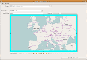
Chi utilizza dei gps Magellan Triton può realizzare facilmente mappe OSM di qualsiasi parte del mondo con pochi click. Basta utilizzare l'applicazione online RMP Creator, sviluppata da Picco.
RMP Creator: http://www.picosaan.de/app/tritonrmp.jnlp (serve Java runtime installato)
- Clickando sul link qui sopra, parte l'applicazione RMP Creator
- Vi verrà chiesto se volete eseguire una applicazione non verificata. Cliccate su Esegui.
- Selezionate il plugin "OSM online tile service" e il tipo di render OSM desiderato (OSM Cycle Map, Mapnik oppure Osmarenderer)
- Zoommate fino ad ottenere l'area desiderata per la vostra mappa
- Selezionate i Levels che desiderate avere nella vostra raster map
- Clickate su "Execute conversion"... Dopo qualche secondo/minuto (dipende dalla dimensione) avrete la mappa sul vostro PC.
- Copiatela sulla SD card del Triton ed è fatta! (Chi usa i modelli Triton 200 e 300, può trasferire la mappa al gps con Vantage Point)
Create maps via imi format
Here is a link with information on how to create your own maps:
The summary is: "Custom maps are generated by loading shape (shp) files into MobileMapperOffice, generating an imi file and converting this imi file to Explorist format using MMOconvertor. The imi file is loaded into the GPSr (and Mapsend Lite) as a Detailed map."
You may be able to skip step 1 if you download (OpenStreetMap) Shapefiles 'unconfirmed
If you speak german you may prefer these guides:
- http://magellanboard.alpentourer-alpenpaesse.de/viewtopic.php?t=65
- http://magellanboard.alpentourer-alpenpaesse.de/viewtopic.php?t=1448
Unit Reviews
Magellan 320
An old-ish model, a big player in its day. You can find these cheaply second hand, or maybe as gifts. Large black & white display plots your tracks and POI. Its big, gets a decent signal lock.
Memory is small, something like 500 POI or 1K of track points. Battery life is short, you definitely want to get some rechargeable AA. Data transfer is via a serial cable interface, so I had to buy a Serial-USB cable as well. gpsbabel understands the Magellan format, but not completely — timestamps are often missing from transfers, so I need to postprocess.
My more enthusiastic review from last year
In summary, if you find this in an old drawer, go for it. Otherwise buy something else.
Rummy notes:
I have a similar timestamp problem with gpsbabel and my old Magellan 315 — the problem turned out
for the most part to be enabling debug output while downloading. Even without debug on the the
dates are wrong (on my 315) typically somewhere in 1999, though the time seems OK.

Another item to watch when downloading is the Datum. The trackpoints downloaded from the Magellan
unit are in the datum used when recording, and are not converted to WGS84 (the OSM standard). For
this reason I have my unit set to use WGS84 as the primary datum and OSGB as the secondary datum.
Magellan eXplorist 100
No Interface. No Chance to get Data in and out.
Display: grey
Magellan eXplorist 210
Interface: USB
Display: grey
Memory: 22 MByte internal, not extensible.
Recording : 150 tracks, each containing up to 2 000 points, minumum distance 10 m 2 AA batteries, 18 hours. Retail Price ~ 275 Euros,
- Pros:
- mine was a real bargin
- came with USB Cable (important, beacause it looks quite exotic)
- Cons:
- Loading time when manipulating tracklogs
- Options for tracklogs are well hidden and not wholly satisfying
- Hints:
- When using GPSBabel to convert tracklogs, don't bother to convert to Mapsend first.
Magellan eXplorist 400
Interface: USB
Display: grey
Memory: 6 MByte internal + SD-Card
Magellan eXplorist 500
Interface: USB
Display: color
Memory: 6 MByte internal + SD-Card
Magellan eXplorist 500 LE
Interface: USB
Display: color
Memory: 6 MByte internal + SD-Card
Magellan eXplorist 600
Interface: USB
Display: color
Memory: 6 MByte internal + SD-Card
Magellan eXplorist XL
Interface: USB
Display: color
Memory: 30 MByte internal + SD-Card
Magellan SporTrak Pro
Interface: serial cable
Display: monochrome
Memory: 3000 Trackpoints
Disadvantages: The Memory, 3000 Points means 30km in 10 Meter distance, which i use for mapping with bicycle. It starts to delete from the beginning without notification, so you have to watch the driven distance by yourself. Setting it to 50 meters gives you about 200 Kilometers which is ok for mapping with the car. What I'm missing is the ability to set points every second or so. Be careful if the device shows "Empty Batteries": 2 minutes later, when the device switches off, you will loose your track. So switch off, change batteries and switch back again.
Advantages: It can show maps, probably at some point in time OSM maps. But for now you can see the track you have driven on the map of the device and find streets that you want to map. It finds its position very fast, and does not use it while driving. Batteries (2×AA) hold for about 20 Hours.
Magellan Triton Range
The new triton range looks like it has the potential to be good... Details seem to be lacking a bit at the moment, but, as an example, the Triton 2000 is supposed to have the following features... 2.7" colour touch screen, 2 megapixel camera with location tagging of photos, voice recorder allowing audio to be attached to waypoints, SD card, 3 axis electronic compass, whatever that means, barometer, and SiRFstarIII... That seems to be a pretty good mix of features, if it has some decent tracking options to go with them and generally good performance, this could be the new Garmin GPSMAP 60Csx...