JOSM/Plugins/ElevationProfile


The JOSM Plugin ElevationProfile displays the profile of a GPS trace's elevation measurements. It also shows the minimum and maximum elevation in a separate layer.
| Icon | JOSM Version | Plugin Version | Maintained By | Date | Maturity |
|---|---|---|---|---|---|
| 6162 | 29979 | OliverW | September, 27th, 2013 | Beta |
Revision History
| Version | Changes |
|---|---|
| 29979 | Fix: Cursor showed zero elevation, if no SRTM data is found |
| 29977 | Fixes plot repaint problem / experimental elevation grid (see image 4) |
| 29952 | Fixes Ticket #8080 |
| 29879 | Option to read elevation data from SRTM files |
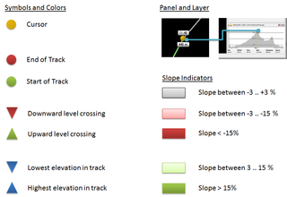
| 29875 | Distinguish between high/low elevation gain/loss (elevation changes < 3% are displayed in gray), new icon |
| 28150 | Fixes Ticket #7549 |
| 27286 | Removed en_GB from list of imperial countries |
| 26946 | Fixes Ticket #6991 |
| 24034 | Fixes Ticket #5598 |
| 23977 | Fixes Ticket #5558 |
Installation
- Open JOSM and select from menu Edit > Preferences, then choose the tab Plugins.
- Check ElevationProfile in the list (see figure 1), then press Update. JOSM should then download and install the plugin.
- Finally restart JOSM, that's it.
Usage
Quite simple, really. The elevation mode is (de)activated via the (![]() ) button, you should find it on the left toolbar. This mode is enabled by default after installation. If you do not need it, simply press the button and the elevation profile window disappears.
) button, you should find it on the left toolbar. This mode is enabled by default after installation. If you do not need it, simply press the button and the elevation profile window disappears.
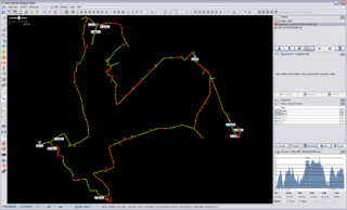
Besides the panel on the right side you see also an additional layer named Elevation profile. This layer shows you the
- Minimum elevation (a blue triangle directing to the bottom) and the elevation in meters
- Maximum elevation (a blue triangle directing to the top) and the elevation in meters
- Start and end of the track (large green/red sphere).
- The other way points are shown in 'green' for elevation gain or 'red' for elevation losses.
- Labels with green triangle indicate a crossing of an elevation level in upward direction, red in downward.
- Cursor: Move the mouse over the profile and see the corresponding point in the map view as a large yellow sphere, labeled with the corresponding time and elevation.
See figure (3) for an example.
Use SRTM data
Since V29879 the plugin is able to read elevation data from external SRTM files
The (unzipped) HGT files must be deployed in one of the following directories
- <Windows User Home>\AppData\Roaming\JOSM\elevation
- C:\ProgramData\Roaming\JOSM\elevation
- \usr\local\share\josm\elevation
- \usr\local\lib\josm\elevation
- \usr\share\josm\elevation
- \usr\lib\josm\elevation
Notes:
- Currently the plugin can only process a resolution of 3 arc seconds (SRTM3)
- This feature is experimental. If you encounter problems, please remove the HGT files from the directories.
- The Elevation Grid requires also HGT files (background gets currently blue, if files are missing)
Hints
- The elevation panel shows only a subset of the waypoints, depending on the panel size.
- An elevation label is hidden, if it overlaps with another label. Thus, the range of elevation labels may look inconsistent (e. g. an "400m downhill" is followed by a "300m uphill". Zoom in to see missing labels.
If you have further suggestions or questions - feel free to drop me a line.
GPS Elevation Data
Many GPS devices log the elevation. Please refer to the manual or check your GPX file for tags named "ele".
Known Bugs and Workarounds
- The elevation profile does not update when selecting another GPX layer. This is because JOSM does not notify listeners when the layer selection changes.
 Workaround: Select the desired layer and change its visibility.
 - The current version is only able to show a downsampled overview. Further levels of detail are considered in the model, but are not accessible via the UI yet. Please be patient.
Feedback
Please report bugs or annoyances to me by either
- send me a mail OR
- create a new TRAC ticket