Karangligar Village Flood Response (Simulation)
| General Information | |
|
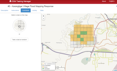
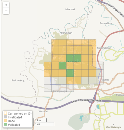
The flooding impacts on three provinces: DKI Jakarta, West Java and Banten. A total of 15 Cities/Districts, 136 Sub-districts and 482 Villages are affected. Karangligar Village in Karawang Regency, West Java was one of many areas which hit badly by flood around Jakarta, West Java and Banten Province in early November 2015. By Saturday, 7 November 2015 morning the death toll is 48 persons with more than 90,000 houses inundated and almost 1.4 million people affected (see Flooding Impact Data for specific details). IDPs have made emergency camps on road sides (in higher locations), others have sought shelter at Police stations, schools, mosques, train stations, and relatives’ houses. Humanitarian OpenStreetMap Team (HOT) volunteers assisted to boost the map coverage of Karangligar village for aid agencies to use OpenStreetMap for their response. Specific Impact on Karangligar Village
Nowadays, anyone can consult free OpenStreetMap Online maps, Routing services or even bring the Map on their Smartphone. For crisis like this Pam Cyclone, contributors from around the world digitize rapidly the data from Satellite imagery to support the humanitarian organizations that deploy in the affected countries. Our goal is to contribute to humanitarian relief by providing rapidly a detailed and accurate map (i.e., road network, villages, buildings, etc.) to support the humanitarian organizations. These services help locate people at risk rapidly, and facilitate the delivery of goods and services to remote areas. The OSM servers, Editing tools and Map and Export products let us offer a variety of free Map and Export services to the humanitarian community. The OSM community support to these Activations is also impressive. The Humanitarian OpenStreetMap Team assures the bridge between the OSM community and the humanitarians. We partner with various international organizations and take the responsability to map quickly various areas while the international organizations deploy in the field to respond to this epdidemy and support the local communities.  [http://tasks.openstreetmap.id/project/3# Task Manager - Crowdsourcing digitalization of buildings
| |
Map and Data Services
About OpenStreetMap
OpenStreetMap offers an online map and spatial database that is updated by the minute. Various online maps are based on OpenStreetMap, including Navigation tools such as OSRM. Tools and services allow data extracts for GIS specialists, routable data for Garmin GPS, GPS navigation with smartphones and other device-compatible downloads. With an Internet connection, regular syncing is possible, because there is open access to the community-contributed data as it comes in. Also bulk with downloads of OpenStreetMap data are ideal for use offline. In addition, maps can be printed to paper, if needed.
Browse the Map to get a feel for the data that is currently available. Different map styles, including a special Humanitarian style, can be selected on the right side of the screen. Though some data may not render (appear) on the online map, it can be exported from the underlying database for other uses requiring more detail(See export section below).
Paper Maps
Large poster-size maps and letter-size paper atlases of custom areas can be printed:
- FieldPapers Paper Maps with grid for field survey or general navigation purposes,
- MapOSMatic Large Paper Maps with grid, street index and POI, good for command centers, hospitals, etc.
Exporting OpenStreetMap and Population data
Daily updates
| OpenStreetMap data by area |
OSM Format |
ShapeFiles for GIS softwares |
Population Data | |
|---|---|---|---|---|
| ● West Java Province (inc. Karangligar Village) | JawaBarat.pbf | Karawang Shapefile(Esri) | Jawabarat.obf (OSMAnd) Jawa Barat Garmin IMG file |
Karawang Population Data |
All files last updated with OSM data 2015-11-07 10:21:02 GMT
Daily OSM updates in various formats and shapefiles are provided by GeoFabrik and the Humanitarian OpenSteetMap Team volunteers. Karawang population data provided by Database of National Disaster Management Agency (BNPB).
Information about the various OSM export formats
- OSM.pbf : These compressed OSM files are recognized by various GIS softwares.
- Shapefile : This data can be imported to GIS software, such as QGIS or ESRI ArcGIS for Desktop.
- OSMAnd.OBF : OSMAnd / Android Offline map and navigation
- » Android File manager: Move the obf file from the download to the OSMAnd directory
- LearnOSM Tutorial Configure OSMAnd, and Offline map navigation
- How to use Voice Navigation
- GPS.IMG : Garmin GPS format
- » Rename the IMG file to gmapsupp.img and move it to the Garmin directory of the GPS card
- Other Mobile devices : See other Mobile device products.
Custom Exports (to be rerun at any time)
OSM extracts, as feature layers (Overpass service)The Overpass queries below let users extract specific layer features. The output is in, OSM format. The links below query the Online Overpass Service, and the file is downloaded automatically. Rename the filename called "interpreter" for better documentation of the Query content.
|
Custom Android/OSMAnd offline file
Install by copying to OsmAnd directory on your Android device. |
With the availability of small communication devices, Offline data for navigation proves to be very useful for humanitarians deployed in foreign countries. We support the humanitarian NGOs using navigation data and invite them to give us feedback on the use of these devices in the context of field deployment. Daily updates assure that the most up-to-date data is available for downloads. With limited communication in a disaster region, it is recommended that users download data in bulk before traveling to these regions for offline use.
- This OSMAnd Tutorial shows how easy it is to navigate with OSMAnd.
- Copy OSMAnd files : Files downloaded are placed in the download directory. Move these files to the osmand directory. After you rerun OSMAnd, these files will be available.
- Copy Garmin GPS files : In general, you should rename the img file to gmapsupp.img and move it to the directory called Garmin. After restarting your GPS, you should see this new map.
Reporting map errors while traveling with OSMAnd
With OSMAnd, you can notify the OSM mappers of problems with the map.
- First enable the "Edit OpenStreetMap" plug-in in OSMAnd by going to "Settings" -> "Plugin-manager" and check the "OSM editing" plug-in.
- Go to the map view in OSMAnd, and long-press near the error you found
- Click on the balloon that pops up and select "Report an error in OpenStreetMap." (if this option doesn't show up, double-check that you enabled the right plug-in)
- Write a human-readable, preferably English message, explaining how to fix the error or what is wrong.
- When you get back to a location with Internet, you can upload the bugs to notify us. Go to "Settings" -> "OSM editing" -> "Locally saved OSM POIs/Bugs" and use the bottom-left button to upload all your bugs.
The bugs will appear on the map, and will be handled when a mapper sees them. The mapper will try to correct the error using your message and the aerial pictures available. Please don't ask questions, as we will probably not be able to answer them. But please describe what's wrong and how it should be.
A message like "This hamlet is called Petifu instead of Wari" will result in a correct map, while a message like "How is this hamlet named?" is unsolvable for us.
After a mapper handles (and hopefully solves) the bug, the correction will be available the next time you download the maps.
About This Humanitarian Activation
About HOT
- To learn more about the Humanitarian OpenStreetMap Team (HOT), explore our wiki pages (root: HOT) or our web site hotosm.org. We are a global community of mostly volunteers. We are also a U.S. nonprofit able to contract with organizations (email info at hotosm.org to contact our staff). And we are a U.S. 501-c-3 charitable organization organization, and donations are tax deductible in the United States.
History of this Activation
Reactivity of the OSM Community
- HOT Volunteers began coordinating mapping 5 November 2015
- Mapping Projects mostly complete by 7 November 2015
Tools, Adaptation and Services
OSM developers communicate over the Internet through various communication channels. In 2013 they implemented the new Humanitarian Map Style, a map more adapted to humanitarian actions. This map, hosted by OpenStreetMap of France, is integrated into various online map tools.
Two OpenStreetMap tools, the Tasking Manager and the JOSM editor, are essential parts of this activation. As new imagery is available, new jobs are added to the Tasking Manager. This tool has allowed HOT to coordinate efforts of mappers around the world. Some days there were more then 200 simultaneous mappers registered on the Task Manager and editing, mainly with the JOSM editor. Other online editors, such as OSM's ID and Potlatch 2 editors, also are used for less-intensive mapping. LearnOSM.org offers material to instruct beginners and more advanced mappers in these editors.
How You Can Contribute
Edit the Map
- You can contribute from the Internet by tracing buildings, roads, waterways, etc. To react rapidly to support humanitarians deploying, we need a lot of contributors for remote editing. Visit LearnOSM.org to get started.
- More experienced OSM contributors are invited to read the guidelines on Highway Tag and to revise the classification of roads. You also can assure the quality of the mapping by validating the Task manager tasks or using the various OSM Quality control tools.
- Humanitarian field teams and knowledgeable local people also are essential. You can complete the map by adding the names of roads or various infrastructure items. You even can edit the map using small mobile devices. In addition, applications are available for online or offline mapping.
- Add a Note or report an Error using the Notes feature on the Online Map. OSM contributors will edit the map from your comments.
Mapping Priority
- Please choose from highest priority first
- For experienced mappers, information on validating the tasks can be found here.
| Job No. | Priority | Location | What to map | Imagery Source | Task Mapping Status | Task Validation Status | Date Job Added |
|---|---|---|---|---|---|---|---|
| Job number 3 | Karangligar Village | buildings, roads, residential areas, communications towers | Bing | On going |
Beyond these, we need experienced mappers to make assessments of missing data on a wider scale. Fix up of place names is needed. There are several old topographic maps of this area with lots of place names listed on them and possibly alternate spellings as well.
Tutorials
General (Using OpenStreetMap)
After finish download the OBF file(s), you need to copy the file(s) to OsmAnd's app directory on your phone. You can change the location of the app directory in OsmAnd settings at section General. /mnt/sdcard/osmand is a good location. (ATTENTION! The mount point of the SD card may be different to /mnt/sdcard.) If you want to store the OBF files at /mnt/sdcard/osmand, you have to set /mnt/sdcard (without osmand) as Storage directory. Please attend that Android is based on Linux and case-sensitive! /mnt/extSdCard and /mnt/extsdcard are two different directories!
Available Imagery
Bing has greatly extended his imagery coverage over the last two years.
How to add to JOSM
It's easy to add special imagery to JOSM from the task manager jobs, where an imagery URL is provided within the task manager. Clicking the URL should trigger JOSM remote control to add the new imagery as a layer. For more details see OSM Tasking Manager/Setting up JOSM
Bing
Bing is the 'default' Imagery available for OSM (default option in most editors). The Bing imagery coverage is complete for the Affected area.
Media coverage
English
- 2015-11-05 Flood in Jakarta and its surrounding area, Jakarta Globe News

