Key:glideslope
Jump to navigation
Jump to search
 |
| Description |
|---|
| Glideslope antenna of an ILS system |
| Group: aeroways |
| Used on these elements |
| Requires |
| Useful combination |
| Status: in use |
| Tools for this tag |
Glideslope antenna of an ILS system
How to map
Set a node ![]() where the antenna is and add
where the antenna is and add
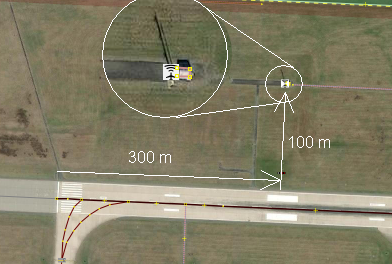
The antenna can be found about 300 m from the beginning of the runway to the left or to the right 100 m to the side
The shadow of the antenna can be seen on accurate satellite images. Just behind it is the transmitter's container. In front of the antenna, an area of 8 x 80 m is kept free of vegetation.
See also
- Instrument landing system glide path on Wikipedia
