Tag:beacon:type=ILS
Jump to navigation
Jump to search
 |
| Description |
|---|
| Instrument Landing System, used for Glide slope as well as for Localizer transmitters |
| Group: aeroways |
| Used on these elements |
| Requires |
| Useful combination |
|
or |
| Status: de facto |
| Tools for this tag |
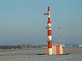
An Instrument Landing System (ILS) is a system that works by sending radio waves downrange from the runway end, with aircraft that intercept it using the radio waves to guide them onto the runway.
The system has the two transmitters Localizer and Glide slope.
They are marked with localizer=yes or glideslope=yes.
How to map
Set a node ![]() where the transmitter is and add
where the transmitter is and add
or
Tags used in combination
beacon:code=*beacon:frequency=*beacon:channel=*operator=*ele=*

-
 Localizer station
 -
 Glide slope station

