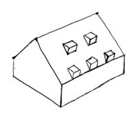
Key:roof:levels

From OpenStreetMap Wiki
Jump to navigation Jump to search
Public-images-osm logo.svg roof:levels
Roof sample 6.png
Description
For stating the number of levels in the roof of a building. Show/edit corresponding data item.
Group: buildings
Used on these elements
may be used on nodesshould not be used on waysmay be used on areas (and multipolygon relations)should not be used on relations (except multipolygon relations)
Requires
Useful combination
Status: de facto

This tag is used for marking the number of roof levels of a building (building=*) or of a building part (building:part=*).

Value should be a positive or zero integer: 0, 1, 2, etc. A level is the space between a floor and a ceiling or, for the highest level, from the floor to the highest edge of the roof. Default height of a level is 3 meters (height used for 3D rendering when height tags are not used). If a level has a different height (for example 2 meters), do not use fractional values but height tags. For example, roof:levels=1 and roof:height=2 (you can stand up in a 2 meters high roof). Or roof:levels=0 and roof:height=1 (you can't stand up in a 1 meter high roof so levels value is zero).

For more information, see building:levels=* and Usage of heights and levels

Examples

Picture Tags
2014-05 Gasthof Obercarsdorf.jpg
roof:levels=2[1]
building=*
building:levels=2
roof:shape=half-hipped
height=11
roof:height=5
Unclear level count - how many levels in roof.jpg
roof:levels=2[2]
building=house
building:levels=1
roof:shape=gabled
height=7
roof:height=4

See also

  • building:levels=* – Number of levels in the facade of a building
  • height=* – Physical attribute of an object (building, tree, tower...). Height is the measurement of vertical distance. It indicates how "tall" something is
  • roof:height=* – Height of the roof
  • Simple 3D Buildings

Possible tagging mistakes

  • roof:levels=0.5 ‒ Value should be an integer, use height tags to express height information
If you know places with this tag, verify if it could be tagged with another tag.
Automated edits are strongly discouraged unless you really know what you are doing!
If you know places with this tag, verify if it could be tagged with another tag.
Automated edits are strongly discouraged unless you really know what you are doing!
If you know places with this tag, verify if it could be tagged with another tag.
Automated edits are strongly discouraged unless you really know what you are doing!
If you know places with this tag, verify if it could be tagged with another tag.
Automated edits are strongly discouraged unless you really know what you are doing!

References

  1. This building will not have a good 3D rendering because it is very difficult to show a roof with 2 different height for the 2 levels because of the half-hipped shape: the first floor is 3 meters high but the last floor is 2 meter high. Rendering will show 2 levels of 2.5 meters high for each.
  2. discussed in https://lists.openstreetmap.org/pipermail/tagging/2022-July/065027.html thread