MappingMyVotingCenter
My Voting Center in OpenStreetMap is a project initiated by MapBuds in 2022 in collaboration with GESAN (Geomatics Engineering Students' Association of Nepal), GES (Geomatics Engineering Society) and GEC (Geomatics Engineering Club) which aims to map out all the 10,888 voting centers or polling stations designated by Election Commission Nepal for federal, provincial and local level elections. This project has been started 2 weeks before the federal and provincial elections, 2022. This project focuses to involve all the OpenStreetMap across Nepal to map their voting center.
Instructions for mapping Voting Centers
List of Voting Center
There are 10,888 voting centers designated by the Election Commission Nepal. The list of these voting centers can be found here.
Tagging scheme for Voting Center
In Nepal, generally some rooms or blocks of schools and community buildings are used as the voting centers or polling stations for the purpose of voting in the election. While mapping a polling station in OpenStreetMap, we will add a node for a voting center and tag it.
| Description | Tags used |
|---|---|
| A voting center or polling station is a place where people vote, i.e. where ballots are cast. It can be a room in a building where voter registrations are checked, ballot papers are provided, and ballot box are available to put the ballot papers. | Required Tags
Naming Tags
|
Mapping via ID editor
One of the easiest ways of adding Voting Centers (amenity=polling_station) is using the in-browser editor at openstreetmap.org, which is called iD.
Steps:
- First, click Login in the righthand upper corner and either register yourself or log in if you’re registered already. You have to have an account in order to edit the map.
- Navigate the place where your voting center is located center the map image on that place. Alternatively, you can use the Search box on the left-hand side to find your area, or use the zoom button to zoom out then slide the map to your desired location, and zoom back in. Since most of the voting centers in Nepal are located within the government schools or public buildings, searching the name of schools can assist in finding out the voting center.

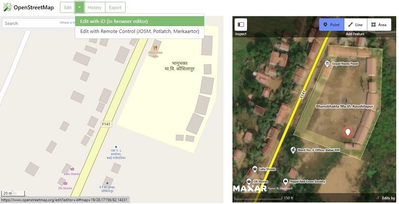
- Click the small arrow to the right of the word Edit above the map. There will be a drop-down menu. Select “edit with iD”. Once all the mapped features on top of a nice satellite image provided by Maxar Premium Imagery or Bing (whatever is the latest), you can see a hand replace the arrow of the mouse pointer. Then you can grab and slide the map around to make sure it’s in the right place. fter knowing the correct position of the voting center and centering, we will click on the point on the edit toolbar of the iD Editor interface and then add a node for voting center.

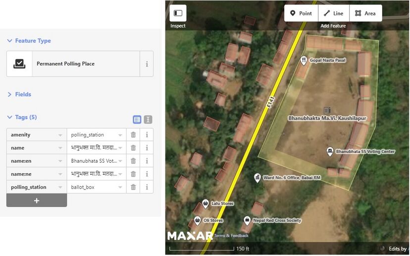
- Then the node is provided with correct tags. These tags are add:
amenity=polling_stationpolling_station=ballot_boxname=*name:ne=*name:en=*
- An example of tagging is:
- Adding a polling_station of Ward No. 6 of Babai Rural Municipality, Dang located at Bhanubhakta Secondary School:
- An example of tagging is:
 amenity=        polling_station
 polling_station=ballot_box
 name=           भानुभक्त मा.वि. मतदान केन्द्र
 name:ne=        भानुभक्त मा.वि. मतदान केन्द्र
 name:en=        Bhanubhakta SS Voting Center

- Now Click on Save and then provide proper changeset comment with hashtags and your voting center is added in the map.

Hashtags
#mapbuds #digitalnepal #nepalelection2022 #gesan #ges #gec