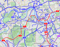
An international cycling map created from OSM data is available, provided by Andy Allan. The map rendering is still being improved, the data are updated every few days. It shows National Cycle Network cycle routes, other regional and local routes, and other cycling-specific features, such as:
- dedicated cycle tracks and lanes
- contours and hill colouring
- bicycle parking
- bike shops, toilets, drinking fountains, even pubs!
- proposed bike routes (or numbering protocols), contrasted with the Lonvia map, below, which does not show proposed routes, but actual routes only
http://www.opencyclemap.org/
|
| CyclOSM A free cycle-oriented map with more features than OpenCycleMap. See its wiki page CyclOSM.
|
| Waymarked Trails: Cycling by Sarah Hoffman is a layer superimposed over mapnik (Standard Map Layer) which shows marked cycle routes around the world. Updated minutely, it renders actual routes without the state=proposed tag. Therefore no proposed routes (or proposed numbering protocols) are displayed.
|
Mark all member relations as network=ncn + cycle_network=US:US + ref=number + only if actually proposed, state=proposed. Please keep this list synchronized with United States Bicycle Route System.
| USBR Number |
Relation |
Status and notes
|
| 21 |
3087492 3087492 3087492 |
AASHTO-approved, fully entered into OSM.
|
| 25 |
12922795 12922795 12922795 |
AASHTO-approved, fully entered into OSM.
|
| 30 |
12924895 12924895 12924895 |
AASHTO-approved, fully entered into OSM.
|
| 40 |
No relation yet |
Believed to partially follow the Great Ohio Lake-to-River Greenway in eastern Ohio but otherwise follows State Bike Route K, which has not been mapped. Is there a published Route K map available? (in which case K should be entered into OSM as an rcn)
|
| 44 |
12925038 12925038 12925038 |
AASHTO-approved, fully entered into OSM.
|
| 50 |
2532494 2532494 2532494 |
AASHTO-approved, fully entered into OSM.
|
| 50A |
2532436 2532436 OH:FRA, OH:DEL, OH:LIC segment 2532436 OH:FRA, OH:DEL, OH:LIC segment |
Northeast of Columbus area. AASHTO-approved, fully entered into OSM.
|
| 225 |
12922779 12922779 12922779 |
AASHTO-approved, fully entered into OSM.
|
| 230 |
12925019 12925019 12925019 |
AASHTO-approved, fully entered into OSM.
|
State bike routes
Mark all member relations as network=rcn + cycle_network=US:OH + ref=number. The lettered routes below are designated by ODOT; tag them as operator=Ohio Department of Transportation. (Most other routes are maintained by county park districts. For such routes that cross county lines, place the operator=* tag on the individual ways, not the relation.)
| Ohio Bicycle Route Number |
Name |
Relation |
Status and notes
|
| 1 |
Ohio-to-Erie Trail |
118953 118953 118953 |
From current southern terminus in Newtown north and east to Big Darby Creek in Georgesville, over the Little Miami Scenic Trail Little Miami Scenic Trail and Prairie Grass Trail Little Miami Scenic Trail and Prairie Grass Trail Prairie Grass Trail. From Cleveland south to Massillon over the Ohio & Erie Canal Towpath Trail Prairie Grass Trail. From Cleveland south to Massillon over the Ohio & Erie Canal Towpath Trail Ohio & Erie Canal Towpath Trail. Little Miami Scenic Trail State Park mapped from southern terminus to Loveland with 80297 Ohio & Erie Canal Towpath Trail. Little Miami Scenic Trail State Park mapped from southern terminus to Loveland with 80297 80297. 80297.
|
| 1A |
Ohio-to-Erie Trail Alternate |
N/A |
Ohio-to-Erie Trail website describes likely routing of Alternate Bike Route 1. [1]
|
| 2 |
Creekside Trail |
66188 66188 66188 |
Complete.
|
| 2A |
Beavercreek Trail Connector |
1742141 1742141 1742141 |
Complete.
|
| 3 |
|
1738747 1738747 1738747 |
From Newtown to north of Urbana over the Little Miami Scenic Trail Little Miami Scenic Trail and Simon Kenton Trail Little Miami Scenic Trail and Simon Kenton Trail Simon Kenton Trail. Concurrency with Bike Route 1 is marked as Bike Route 1/3, thus rcn_ref=1/3. Simon Kenton Trail. Concurrency with Bike Route 1 is marked as Bike Route 1/3, thus rcn_ref=1/3.
|
| 3E |
Ellis Spur Bikeway |
1735294 1735294 1735294 |
Complete.
|
| 4 |
Jamestown Connector |
186187 186187 186187 |
Current western terminus to Jamestown.
|
| 5 |
Wright Brothers Bikeway |
1782994 1782994 1782994 |
Complete.
|
| 7 |
Stillwater River Recreation Trail |
1783224 1783224 1783224 |
Complete.
|
| 8 |
Mad River Recreation Trail |
68434 68434 68434 |
From Harries to I-75.
|
| 9 |
Iron Horse Trail |
125716 125716 125716 |
Complete.
|
| 25 |
Great Miami River Recreation Trail |
337481 337481 337481 |
Various finished segments from Fairfield to Piqua.
|
| 36 |
Ohio-to-Indiana Trail |
1156541 1156541 1156541 |
Complete.
|
| 38 |
Wolf Creek Recreation Trail |
207938 207938 207938 |
In Trotwood and Dayton.
|
| 40 |
Buck Creek Scenic Trail |
1740804 1740804 1740804 |
Complete.
|
| 47 |
Olentangy Greenway Trail |
1873482 1873482 1873482 |
Unclear whether the statewide numbering scheme was aligned with Columbus' or the other way around.
|
| 66 |
Canal Run |
1795498 1795498 1795498 |
Complete.
|
| A
|
| B |
|
122939 122939 122939 |
In Cincinnati, from Broadway St. to Dana Ave.
|
| C |
|
1738643 1738643 1738643 |
From southern terminus at the Kentucky state line north to Newtown.
|
| E
|
| F
|
| J
|
| K
|
| N
|
| CT |
Cardinal Trail
|
County bike routes
In counties that maintain a distinct county route system, mark relations as network=lcn + cycle_network=US:OH:XYZ + ref=number (optional), where XYZ is the three-letter county code found at Ohio#County abbreviations. Here are some known county bicycle route networks:
cycle_network |
County |
Shield |
Notes
|
| US:OH:LIC |
Licking |
|
|
| US:OH:SUM |
Summit |
|
|
