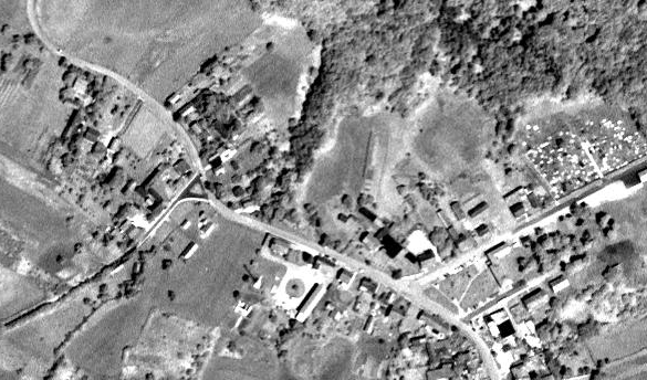
OrbView-3
GeoEye's OrbView-3 satellite high-resolution imagery in USGS possesion is public domain.
Articles form usgs newroom and vector1media.com give some information.
Example
Public domain
The USGS have clearly declared this imagery to be public domain, and we can therefore use this for deriving our vector maps trouble-free!
- "Yes, it is public domain. There is no legal requirement for users to acknowledge or credit USGS as the source for public domain information, but they may wish to do so as a courtesy." (full email)
We give credit on the Contributors wiki page.
We should also use a source=* tag (not required for legal attribution, but we do this anyway to provide good meta-data) TODO document what the source tag is
Available in editors
Some OrbView3 imagery has been tiled-up ready for editing.
- One image of Syria was manually rectified: WikiProject Syria#Available imagery
- TMS service for Croatia and neighbors: WikiProject_Croatia/Podloge#OrbView3
Coverage of Croatia TMS, new imagery sets added recently: http://osm-hr.org/orbview.htm There will be more with time.
- 1464 images of Mali, with less than 10% cloud cover, processed at level L1Gst: 2012 Mali Crisis#Orbview 3.
- About a thousand images of Niger, with less than 10% cloud cover, processed at level L1Gst.
- 144 images of Bangladesh, with less than 10% cloud cover, processed at level L1Gst.
Use with Potlatch :
For Potlatch 2, in menu "Background / Edit / Add", give a name (for example "Country - OrbView-3"), and copy the URL given in the following table.
(You can also uncheck "Dim").
For Potlatch 1, open "Options (choose background map)" dialog window, and copy-paste the URL given in the following table for Potlatch2 in "Custom", replacing "$z/$x/$y" with "!/!/!". (You can also uncheck "Dim background").
Use with JOSM :
To make the image available in the Imagery menu in JOSM, go to Modify / Preferences / WMS - TMS tab / +, give a name (for example "Country - OrbView-3"), and copy-paste the URL given in the following table in "Web address" (bottom).
| Country (with link to coverage map) | URL for Potlatch2 | URL for JOSM |
|---|---|---|
| Bangladesh | http://osm.arkemie.org/cgi-bin/tiles/1.0.0/bangladesh/$z/$x/$y | tms[19]:http://osm.arkemie.org/cgi-bin/tiles/1.0.0/bangladesh/{zoom}/{x}/{y} |
| Colombia | http://osm.arkemie.org/cgi-bin/tiles/1.0.0/colombia/$z/$x/$y | tms[19]:http://osm.arkemie.org/cgi-bin/tiles/1.0.0/colombia/{zoom}/{x}/{y} |
| Croatia, Slovenia, Bosnia, Hungary, Serbia, Monte Negro | tms[18]:http://tms.osm-hr.org/orbview/$z/$x/$-y.png | tms[18]:http://tms.osm-hr.org/orbview/{zoom}/{x}/{-y} |
| Mali | http://osm.arkemie.org/cgi-bin/tiles/1.0.0/mali/$z/$x/$y | tms[19]:http://osm.arkemie.org/cgi-bin/tiles/1.0.0/mali/{zoom}/{x}/{y} |
| Niger | http://osm.arkemie.org/cgi-bin/tiles/1.0.0/niger/$z/$x/$y | tms[19]:http://osm.arkemie.org/cgi-bin/tiles/1.0.0/niger/{zoom}/{x}/{y} |
| Philippines | http://osm.arkemie.org/cgi-bin/tiles/1.0.0/philippines/$z/$x/$y | tms[19]:http://osm.arkemie.org/cgi-bin/tiles/1.0.0/philippines/{zoom}/{x}/{y} |
| South Sudan | http://osm.arkemie.org/cgi-bin/tiles/1.0.0/southsudan/$z/$x/$y | tms[19]:http://osm.arkemie.org/cgi-bin/tiles/1.0.0/southsudan/{zoom}/{x}/{y} |
| Slovakia | tms:http://93.184.70.94:21880/tilecache/tilecache.fcgi/1.0.0/OrbView-3_1GST/{zoom}/{x}/{y}.jpg | |
| Russia & ex-USSR countries | unavailable | wms:http://osm.sbin.ru/ov3/?SERVICE=WMS&VERSION=1.1.1&REQUEST=GetMap&LAYERS=orbview3rec,orbview3pv&SRS={proj(EPSG:4326)}&WIDTH={width}&height={height}&BBOX={bbox}&format=image/jpeg |
Use source=OrbView-3, USGS, 2003-2007.
Images are terrain corrected (L1Gst). As with Bing imagery, it is recommended to use GPS tracks, when available, to check alignment and adjust offset. In several places, it has been found that an offset of some 20 m can be expected.
Getting OrbView-3 imagery into editors
It's a fairly awkward process to get bits of this imagery ready for OSMers to use as a background within editors.
Finding images in earthexploror
You can find patches of OrbView-3 imagery using the USGS earthexplorer map interface. Before you spend ages wrestling with this interface you should know that you cannot download the scenes without going through quite an onerous registration process. But here's how to find patches of coverage:
- In the left hand panel go to to the 'search criteria' tab
- Down in the 'coordinates' section. click 'use map'
- position zoom out a bit then drag your four red markers to enclose the part of the world you're interested in
- Click 'Data sets'
- Select expand and then tick the 'OrbView 3' option
- Click 'Results>>' at the bottom
Hopefully you'll get some matches. If not go back to search criteria, and maybe try a larger area. Matches are shown as very tiny thumbnails of the orbview imagery, but even here you can see that some images are uselessly covered in cloud. Select the footprint icon to see on the map the area where each match covers. You can go down and click the footprint for all the matches to get a feel for what's available. Then use the little download icon next to a match to download a massive image (registration required)
Coordinating downloading images
We could also re-host images we've downloaded. They are public domain after all. This could save everybody having to register on the USGS site.
The folks behind osm-hr.org were making a start with this (WikiProject Croatia and User:Hbogner)
Edited 1GST imagery is available for download:
http://data.osm-hr.org/orbview-3/
Rectifying and tiling
Having downloaded a massive image, the next step is to rectify it and chop it up into tiles. This is a technical process, usually achieved with GDAL tools. Probably already explained elsewhere on the wiki. TODO:Link
