Pakistan Flood 2022
| General Information | ||||||||||||||||||||
For Size-up, updates and more information visit this . | ||||||||||||||||||||
About This Disaster Mapping Project(or Activation)
History of this Activation
Reactivity of the OSM Community
- 29 August 2022 - HOT Disaster Manager for the Asia-Pacific hub, and local, Harry Mahardhika notified the HOT Disaster Services of the flooding and began contacting local mappers and staff from the local community there
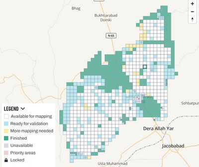
- 31 August 2022 - First mapping project launched on the Nashirabad District
- 15 January 2023 - Mapping Project Complete
For Mappers
- Thank you, this response is now complete!
How You Can Contribute

Learn to Map
- Most of our volunteer needs are for remote OSM contributors, visit LearnOSM.org to get started.
Mapping Priority
- Please choose from highest priority first
- Experienced mappers are also asked to participate in validating completed tasks. Information on validating can be found here
| Project | Priority | Location | What to map | Imagery Source | Overall Progress | |
|---|---|---|---|---|---|---|
| COMPLETE/ARCHIVED | ||||||
| Pakistan Flood - Nasirabad District | Complete | Nasirabad District | Buildings and Roads | Maxar Premium | Stats | |
For Aid Organizations
Map and Data Services

Download the data
See Downloading data for instructions on getting large scale map data, or see the focused exports below:
- A custom export is available on the HOT Export Tool
- Regularly updated OpenStreetMap exports are available on the Humanitarian Data eXchange (HDX)
| Country | Status | HDX | HOT Export Tool | Partners/Other | |
|---|---|---|---|---|---|
| Pakistan | In Progress | [1] | N/A | N/A |
About OpenStreetMap
OpenStreetMap offers an online map (and spatial database) that is updated by the minute. Various tools and services allow data extracts for GIS specialists, Routable Garmin GPS data, Smartphone GPS navigation, and other device-compatible downloads. With an internet connection, regular syncing is possible with open access to the community contributed data as it comes in, with OpenStreetMap's bulk data downloads ideal for use offline. In addition, maps can also be printed on paper.
Browse the (example) Activation Area to get a feel for the data that is currently available. Different map styles including a Humanitarian style can be selected on the right side, and some data may not render (appear) on the map but could be exported from the underlying database (See export section below).
Paper Maps
Poster size Maps and normal sized paper atlases of custom areas can be printed:
- For print, the World Food Programme has built the Humanitarian Topographic Atlas.
- We suggest FieldPapers Paper Maps with grid for field survey or general navigation purposes.
- See OSM_on_Paper for an overview and list of other platforms and services for printing maps.
With the availibility of Small communication devices, Navigation Offline data proves to be very useful to the humanitarians deployed in foreign countries. We support the humanitarian NGO's using navigation data and invite them to give us feedback on the utilization of these devices in the context of field deployment.
- See Software/Mobile for more information on using OSM in portable devices.
- See also Mobile Mapping on LearnOSM.org for information on mapping in the field.
Usage of OSM data for Humanitarian Missions
- Example CartONG Map
- Please post links/reports here...
Available Imagery
OSM Default Imagery Sources
Bing
Bing provides a global imagery data source that is the 'default' Imagery available for OSM (default option in most editors).
Mapbox
Mapbox provides a global imagery source and should be compared to Bing (typically use Bing for alignment if available and not instructed otherwise).
Alternative Imagery Sources
How to add/use Alternative Imagery
In many cases better imagery is available than the default; when possible we set up a remote link directly via the Tasking Manager, so there is nothing to do, the iD editor and (as long as enabled) JOSM will automatically add the imagery.
Additionally, with JOSM, it's relatively easy to add special imagery if the license is appropriate for tracing into OSM. For more details see JOSM Imagery Help
