Place name party
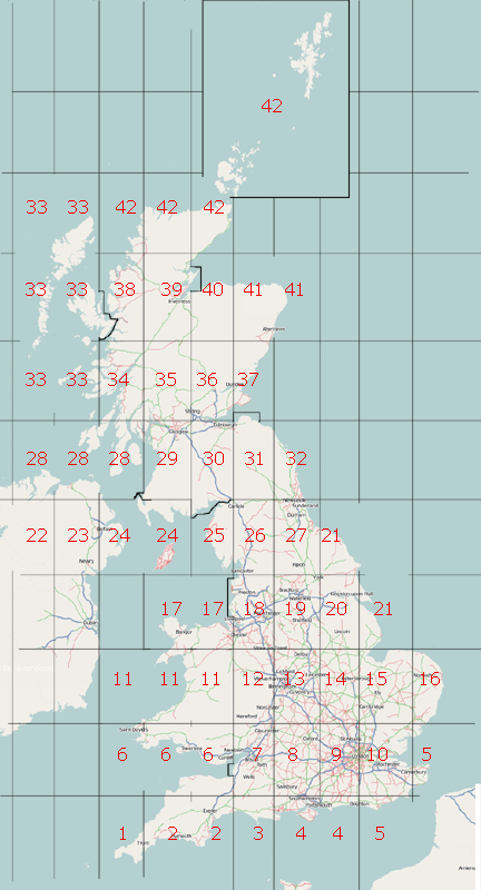
The idea is for each person to select an area (use the table below) and use NPE map background and Landsat images to comprehensively populate the map with places, so that we end up with every place name in the UK represented.
Primarily we are interested in putting place markers on all the towns and villages. In addition please consider adding mountain peaks and generally reviewing the area for problems, for example with coastline. If it can be done with sufficient accuracy, rivers would be good to add as well.
David.earl has been spearheading this idea. See original mailing list post
Software
There is an online POI editor which allows you to easily scroll around the NPE map adding points of interest.
Alternatively, use JOSM with the WMS plugin.
Party?
This is not a real party gathering. It's an online "virtual" party.
The original idea was to make this a "party" in that we get stuck all at once, and do it as a concerted push. To make this happen we probably need to chose a date (and start time/end time)
- Start date : May 16
- End time : ideally May 31, but can be revisited
Alternatively we could just call it a mapping "project", if we are just going to chip away at the task whenever we feel like it.
Areas
Most of the areas are one or more whole degree squares. Where there's a little chunk of land in an otherwise disjoint area, I've included it with the obvious square.
By all means do more than one, but just take a square at a time please.
I've suggested excluding certain metroplitan areas because they have changed so much since NPE maps were published that what we add might well be inaccurate.
Area list - choose your squares here
| Area | Centred on | Rough description | Notes | Editor (your name) |
|---|---|---|---|---|
| 1 | 50.5N,5.5W | Land's End | includes Lizard Point which is south of 50° | Keiththomson |
| 2 | 50.5N,4.5W 50.5N,3.5W |
south Devon | silverfish | |
| 3 | 50.5N,2.5W | Portland Bill | ||
| 4 | 50.5N,1.5W 50.5N,0.5W |
Isle of Wight to Brighton | nickw | |
| 5 | 50.5N,0.5E 51.5N,1.5E |
Eastbourne, Hastings, Canterbury and Kent coast | pray4mojo | |
| 6 | 51.5N,5.5W 51.5N,4.5W 51.5N,3.5W |
South-west Wales | beware NPE mis-spellings of Welsh placenames | Welshie |
| 7 | 51.5N,2.5W | Bristol Channel | Started on the West, moving East. Progress stalled at present. --Gwall 13:43, 8 June 2007 (BST) | GrahamW |
| 8 | 51.5N,1.5W | Swindon and Oxford | ||
| 9 | 51.5N,0.5W | West of London | suggest places only outside M25 | |
| 10 | 51.5N,0.5E | Thames Estuary | suggest places only outside M25 | DrMark |
| 11 | 52.5N,5.5W 52.5N,4.5W 52.5N,3.5W |
mid Wales | David.earl | |
| 12 | 52.5N,2.5W | Hereford to Shrewsbury | Richard | |
| 13 | 52.5N,1.5W | West Midlands | suggest outside Birmingham M6/M5/M42 ring | Blackadder |
| 14 | 52.5N,0.5W | Northamptonshire | ||
| 15 | 52.5N,0.5E | Cambridge to The Wash | dotbaz | |
| 16 | 52.5N,1.5E | eastern East Anglia | ||
| 17 | 53.5N,4.5W 53.5N,3.5W |
Anglesey and north Wales | includes western part of the Wirral but not the Lancashire coast | Comsomol |
| 18 | 53.5N,2.5W | Manchester and Liverpool | suggest outside the M60 ring | Peter James |
| 19 | 53.5N,1.5W | Sheffield and Leeds | The very top of this square, central Leeds and north, has been done east to west | Jon |
| 20 | 53.5N,0.5W | Lincoln and Hull | ||
| 21 | 53.5N,0.5E 54.5N,0.5W |
Lincolnshire and Yorkshire coasts | JClark2906 | |
| 22 | 54.5N,7.5W | Fermanagh and Tyrone | includes a small section of NI west of 8°W | |
| 23 | 54.5N,6.5W | Lough Neagh | ||
| 24 | 54.5N,5.5W 54.5N,4.5W |
Belfast, IOM and Stranraer | includes all of Stranraer peninsula but not Cairnryan | |
| 25 | 54.5N,3.5W | Western Lakes | excludes any of Galloway. All places done, + all lakes/tarns. Going back for significant rural roads and mountain peaks. [1] | steve8 (also sq26 as far E as M6) |
| 26 | 54.5N,2.5W | Eden Valley | ^^ | |
| 27 | 54.5N,1.5W | Harrogate up to Newcastle | Michael Collinson | |
| 28 | 55.5N,7.5W 55.5N,6.5W 55.5N,5.5W |
north NI coast, Islay, Kintyre and Arran | excluding little bits of Galloway and Stranraer | |
| 29 | 55.5N,4.5W | Ayrshire | suggest not including urban Glasgow | |
| 30 | 55.5N,3.5W | Southern Uplands of Scotland | includes southern tip of Galloway | Marscot |
| 31 | 55.5N,2.5W | Borders | watch out for the Kielder Water which won't be on NPE | Marscot Scottish side |
| 32 | 55.5N,1.5W | Northumberland coast | twohats | |
| 33 | 56.5N,7.5W 56.5N,6.5W 57.5N,7.5W 57.5N,6.5W 58.5N,7.5W 58.5N,6.5W |
Western Isles | includes all of Skye | |
| 34 | 56.5N,5.5W | Oban, Fort William and eastern Mull | ||
| 35 | 56.5N,4.5W | Rannoch Moor | ||
| 36 | 56.5N,3.5W | Perth | Rightway | |
| 37 | 56.5N,2.5W | Dundee, Arbroath and Montrose | excludes south of Firth of Forth | |
| 38 | 57.5N,5.5W | Wester Ross | excluding Skye | |
| 39 | 57.5N,4.5W | The Great Glen | including Black Isle | |
| 40 | 57.5N,3.5W | Nairn and the Cairngorms | ||
| 41 | 57.5N,2.5W 57.5N,1.5W |
Aberdeen and Fraserburgh | ||
| 42 | 58.5N,5.5W 58.5N,4.5W 58.5N,3.5W |
Sutherland, Caithness, Orkney and Shetland |
Tags
Just as a reminder:
- Places are represented with the following tags
