Proposal:Extended traffic signs tagging/Tools
| Extended traffic signs tagging | |
|---|---|
| Proposal status: | Draft (under way) |
| Proposed by: | yopaseopor |
| Tagging: | traffic_sign=*
|
| Applies to: | |
| Definition: | An extended and advanced scheme to tag all kind of traffic signs |
| Statistics: |
|
| Draft started: | 2017-02-05 |
Tools
Traffic signs presets for JOSM
Traffic_signs_XX preset is a set of 43 presets for JOSM which contains all the combination of tags for more than 12000 different traffic signs. There are presets for traffic signs of Andorra, Argentina, Austria, Australia, Belarus, Belgium, Brazil, Canada, Chile, China, Colombia, Czech Republic, Denmark, Estonia, Finland, France, Germany, Greece, Hungary, Indonesia, Israel, Ireland, Iceland, Italy, Japan, The Nederlands, Norway, Peru, Poland, Portugal, Russia, Serbia, South Africa, South Korea, Spain, Sweden, Switzerland, Slovakia, Turkey, Ukraine, United Kingdom and United States.
In some countries preset is so complete as Spain. Well-Developed countries are Nederlands, Finland and Belgium, and the others has all the basic tagging you can find in their countries traffic laws. You can install it from Edit > Preferences > tagging presets (3rd tab).

Zones
Other tools are divided in zones:
- Traffic_signs_AFR (Africa): South Africa.
- Traffic_signs_AME (America): Canada, United States, Mexico, Brazil, Argentina, Chile, Colombia and Peru.
- Traffic_signs_DE (Germany): Germany from 2017 law. In SVG.
- Traffic_signs_EUR_OC (West Europe):Austria, Andorra, Belgium, Switzerland, Czech Republic, Denmark, Spain, France, United Kingdom, Ireland, Italy, The Nederlands and Portugal.
- Traffic_signs_EUR_OR (East Europe):Belarus, Greece, Estonia, Finland, Hungary, Iceland, Norway, Poland, Russia, Serbia, Sweden, Slovakia, Turkey, and Ukraine.
- Traffic_signs_PAC (Pacific Zone): Australia, China, Indonesia, Israel, Japan and South Korea
Traffic signs presets for Vespucci
As you know newest version of Android app Vespucci cap accept JOSM presets so you can use Traffic_signs_XX presets with your favourite app to edit osm on the ground with the most complete options with a simple touch of your fingers. To execute this specify it to Vespucci in Configuration > Advanced > Presets and then touch Add preset to set the name and the URL of the preset.
Deriviste
Origins of Deriviste
In October 2018, a new OpenStreetMap tool called Deriviste was introduced by Richard Fairhurst. This tool presented the user with a way to directly create OSM data from user images on Mapillary, including by clicking directly on the image. Thanks to an experimental feature in the open-source MapillaryJS library, Deriviste meant that a click in the Mapillary image was translated to a point on the map. Richard borrowed some code from the OpenStreetMap iD editor in order to allow searching for OSM tag presets, then used simple user authentication to allow submission of the newly created data as an OSM changeset.

How it works this fork
With a fork of this tool called Deriviste_traffic_signs you have a simple interface to add nodes to OpenStreetMap based on what you see in Mapillary street-level imagery.
- Click a place on the map with a green highlight.
- Double-click a traffic_sign object on the street imagery to place a node there.

- Use the search box to find the code for this country in the preset.

- Complete the tags using the right-hand tag table (don't forget key side).Delete the code for what direction is not.
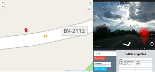
- Repeat until you're done.
- Enter your OSM username and password, then click 'Upload'.
- Make an overpass-turbo query to detect the new nodes (you can try to find traffic_sign:forward or traffic_sign backward)
- Export it to other editor like JOSM, Vespucci, iD or Potlatch. Now you can attach to the road the traffic sign if you want to. Also you can remove any duplicates and generally clean up. The Mapillary API sometimes fails to find co-ordinates for a click.

The currently selected node is shown in red, others in blue. You can drag the nodes around to fine-tune their position. (You can also place nodes by double-clicking on the map.)
Taginfo project
Traffic signs taginfo project (divided by zones) contains almost the majority of the keys and values it can be used with traffic signs. It works well as a stats tool.
You can find:
- Traffic_signs_AFR (Africa)
- Traffic_signs_AME (America)
- Traffic_signs_EUR_OC (West Europe)
- Traffic_signs_EUR_OR (East Europe)
- Traffic_signs_PAC (Pacific Zone)
Renders
OSM Traffic signs test maps
Leaflet
With Leaflet and Overpass you can see some examples how can be rendered traffic signs well-located. There is a repository in Github for these maps. Done by jmrobles from Digitalillusion

OpenLayers
Based on Bicycle Tags Map you can see some examples of the distribution of all king of traffic signs. There is also a repository in Github for this map. Done by Ramiro Balado

Traffic signs JOSM style
Style Traffic signs show more than 12000 traffic signs of the 42 countries mentioned above in JOSM (divided by zones). It places traffic sign on the chosen side and it shows also subkey :2 traffic signs if each traffic sign is in a different node.

Kendzi3D plug-in for JOSM
Kendzi3D JOSM plug-in has a set up and configuration files showing generic +14000 traffic signs of the 42 countries mentioned above. Depends of the country will show you more or less information. Also we split the models into files to assure the content is shown in a good way.
Considerations to do your files
- It is recommended to use SVG models and use programs to do the PNG files like Inkscape
- In the name file inside the code it is important to avoid in the name any non-English character as " " or "'" or any accent.Use normal letters without accents and change " " or "'" with "_"
- In the query inside the code it is important to avoid the use of "'" in the name of the town. You can only change it with "'" (not ") . But this is in the Kendzi3D xml file, don't change any name in OSM to make it suitable to Kendzi3D.
To make it work install Kendzi3D plug-in in JOSM. Then go to 3D > Models library and add these URL files choosing the zone or the country. To see it you have to add these models to your Kendzi3D library:
All concrete references or destinations have to be done, but it can be batch done. Example of all positions you can have in a roundabout traffic sign with JOSM Kendzi3D plugin:


Africa
South Africa
https://raw.githubusercontent.com/yopaseopor/traffic_signs_kendzi3D/master/ZA_traffic_signs.xml
https://raw.githubusercontent.com/yopaseopor/traffic_signs_kendzi3D/master/ZA_2_traffic_signs.xml
https://raw.githubusercontent.com/yopaseopor/traffic_signs_kendzi3D/master/ZA_UP_traffic_signs.xml
https://raw.githubusercontent.com/yopaseopor/traffic_signs_kendzi3D/master/ZA_2_UP_traffic_signs.xml
America
https://raw.githubusercontent.com/yopaseopor/traffic_signs_kendzi3D/master/AME_traffic_signs.xml
https://raw.githubusercontent.com/yopaseopor/traffic_signs_kendzi3D/master/AME_2_traffic_signs.xml
https://raw.githubusercontent.com/yopaseopor/traffic_signs_kendzi3D/master/AME_UP_traffic_signs.xml
Europe
https://raw.githubusercontent.com/yopaseopor/traffic_signs_kendzi3D/master/EUR_traffic_signs.xml
https://raw.githubusercontent.com/yopaseopor/traffic_signs_kendzi3D/master/EUR_2_traffic_signs.xml
https://raw.githubusercontent.com/yopaseopor/traffic_signs_kendzi3D/master/EUR_UP_traffic_signs.xml
Germany
https://raw.githubusercontent.com/yopaseopor/traffic_signs_kendzi3D/master/DE_traffic_signs.xml
Serbia
https://raw.githubusercontent.com/yopaseopor/traffic_signs_kendzi3D/master/RS_traffic_signs.xml
https://raw.githubusercontent.com/yopaseopor/traffic_signs_kendzi3D/master/RS_2_traffic_signs.xml
https://raw.githubusercontent.com/yopaseopor/traffic_signs_kendzi3D/master/RS_UP_traffic_signs.xml
https://raw.githubusercontent.com/yopaseopor/traffic_signs_kendzi3D/master/RS_2_UP_traffic_signs.xml
Spain
For Spain it shows you the generic traffic signs and also it shows specific destination traffic signs. It has the possibility to adapt Spanish panels positions to other destination signs' countries.
To see it you have to add these models to your Kendzi3D library:
For roads:
https://raw.githubusercontent.com/yopaseopor/traffic_signs_kendzi3D/master/ES_words_library.xml
https://raw.githubusercontent.com/yopaseopor/traffic_signs_kendzi3D/master/ES_distances.xml
https://raw.githubusercontent.com/yopaseopor/traffic_signs_kendzi3D/master/ES_milestones.xml
https://raw.githubusercontent.com/yopaseopor/traffic_signs_kendzi3D/master/ES_numbers.xml
https://raw.githubusercontent.com/yopaseopor/traffic_signs_kendzi3D/master/ES_references.xml
https://raw.githubusercontent.com/yopaseopor/traffic_signs_kendzi3D/master/ES_signs_symbols.xml
https://raw.githubusercontent.com/yopaseopor/traffic_signs_kendzi3D/master/ES_roundabouts.xml
https://raw.githubusercontent.com/yopaseopor/traffic_signs_kendzi3D/master/ES_others.xml
https://raw.githubusercontent.com/yopaseopor/traffic_signs_kendzi3D/master/ES_traffic_signs.xml
https://raw.githubusercontent.com/yopaseopor/traffic_signs_kendzi3D/master/ES_2_traffic_signs.xml
https://raw.githubusercontent.com/yopaseopor/traffic_signs_kendzi3D/master/ES_3_traffic_signs.xml
https://raw.githubusercontent.com/yopaseopor/traffic_signs_kendzi3D/master/ES_cities_cat.xml
For motorways:
https://raw.githubusercontent.com/yopaseopor/traffic_signs_kendzi3D/master/ES_mw_motorway.xml
https://raw.githubusercontent.com/yopaseopor/traffic_signs_kendzi3D/master/ES_mw.xml
https://raw.githubusercontent.com/yopaseopor/traffic_signs_kendzi3D/master/ES_mw_numbers.xml
https://raw.githubusercontent.com/yopaseopor/traffic_signs_kendzi3D/master/ES_mw_words_library.xml
Asia–Pacific
https://raw.githubusercontent.com/yopaseopor/traffic_signs_kendzi3D/master/PAC_traffic_signs.xml
https://raw.githubusercontent.com/yopaseopor/traffic_signs_kendzi3D/master/PAC_2_traffic_signs.xml
https://raw.githubusercontent.com/yopaseopor/traffic_signs_kendzi3D/master/PAC_UP_traffic_signs.xml
Levant
Israel
https://raw.githubusercontent.com/yopaseopor/traffic_signs_kendzi3D/master/IL_traffic_signs.xml
https://raw.githubusercontent.com/yopaseopor/traffic_signs_kendzi3D/master/IL_2_traffic_signs.xml
https://raw.githubusercontent.com/yopaseopor/traffic_signs_kendzi3D/master/IL_UP_traffic_signs.xml
https://raw.githubusercontent.com/yopaseopor/traffic_signs_kendzi3D/master/IL_2_UP_traffic_signs.xml
Developers
To contribute to any of these parts of this project there are some Github repositories like this:
https://github.com/yopaseopor/beta_preset_josm
https://github.com/yopaseopor/deriviste
https://github.com/yopaseopor/beta_style_josm
https://github.com/yopaseopor/traffic_signs_kendzi3D
https://github.com/yopaseopor/traffic_signs_map
Please comment on the discussion page of the proposal.
References
http://www.dgt.es/revista/archivo/pdf/num175-2005-Seniales.pdf